
|
|
Mountain/Rock |
|---|---|
|
|
47.09537°N / 12.28683°E |
|
|
Hiking, Mountaineering, Ice Climbing, Big Wall, Mixed, Scrambling, Skiing |
|
|
Spring, Summer, Fall, Winter |
|
|
10869 ft / 3313 m |
|
|
Overview
Mauerekeeskopf, 3313 is a mountain with four main peaks. It is located on the main ridge of Venediger group that comes from Grossvenediger, 3667m. Exactly is located between Grosser Geiger, 3360m on the NE side of the ridge and Simonyspitze, 3488m on the SW side of the ridge. As I said there are four main summits. The most southern is Vorderer Maurerkeeskopf, 3225m, then Mittlerer Maurerkeeskopf, 3281m, the highest one Hinterer Maurerkeeskopf, 3313m and the last one Kleiner Maurerkeeskopf, 3205m.Three large glaciers surround Maurerkeeskopfs. On the north side is a huge glacier Obersulzbachkees that is located below the north faces of Hinterer Maurerkeeskopf, Kleiner Maurerkeeskopf and then more to the east below Grosser Geiger and Grossvenediger. Below the SE side is another huge glacier Maurerkees that is located above the valley MaurerTal. It comes to the top of three summits. On the NW side of Maurerkeeskopf is the glacier Krimmlerkees.
 Panorama from the Grosser Geiger, 3360m. Click on the image for the names.
 Descending through the valley Mauretal.
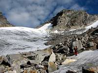 Below the Kleiner Maurerkeeskopf, 3205m.
The summits are hardly approachable. Not because of extreme difficulties of climbing but because of wild glaciers with full of ice falls, seracs and crevasses. The easiest is the approach on Kleiner Maurerkeeskopf from the notch Maurertörl, 3108m and on the Hinterer Maurerkeeskopf also from this notch. It is a climbing of UIAA II-III.. It is harder to Hinterer. For more information check the Routes overview section. Both other summits are typical hard glacier climb over many crevasses and seracs. Down from the valley MaurerTal that is on the SE side of the mountain are not well visible the slopes of glaciers. So we see the difficulty of the glacier when we come on the glacier.
These four summits are very rarely visited because of many more important peaks around. If we want to be alone on a big tour in the montains this is the best goal for climbing.
Getting There
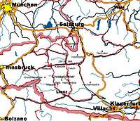 Location map.
Getting there depends on in which valley you want to start your trip.
South approach
For the south approach you have to follow the road until Matrei, then the Virgental to the end of the valley to the village Streden, 1403m where there is a parking place. You have to pay 3 euros for one day or 9 euros for one week.
North approach
For the north approach you have to go to the Salzach valley until Neukirchen (941 m)otherwise follwing the Felbertauern-Road through the tunnel. You can hire a taxi to the Postalm, 1699m. You must park you car in the Hopffeldboden, 1080 m.
 Overview map of Venediger group.
Maps
Alpenvereinskarte (Map of the german/austrian alpine club) 1:25.000 Nr. 36 Venedigergruppe.
Routes Overview
 Below the east face of Hinterer Maurerkeeskopf, 3313m.
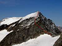 The scheme of route over the east face.
 On the start of the nasty moraine of Maurerkees.
 Hinterer Maurerkeeskopf, 3313m. From the pass Maurertörl, 3108m to the summit over the east face. The pass is approachable from the north ( the hut Kuersinger Huette) and south side (the hut Essener-Rostocker Huette). From the pass you see shelf that goes from the pass and crosses the steepest part of the east face. Later up some easy climbing to the top. Kleiner Maurerkeeskopf, 3205m. From the pass Maurertörl, 3108m to the summit over the east face. The pass is approachable from the north ( the hut Kuersinger Huette) and south side (the hut Essener-Rostocker Huette). From the pass over the west ridge to the top. Some easy climbing and scrambling. Mittlerer Maurerkeeskopf, 3281m. From the valley MaurerTal over the best passages crossing the wild glacier Maurerkees. One of the possibility is from the start of the SE ridge of Simonyspitze, 3488m. This is hard glacier climb with many crevasses. Vorderer Maurerkeeskopf, 3225m. Like on Mittlerer. From the valley MaurerTal over the best passages crossing the wild glacier Maurerkees. One of the possibility is from the start of the SE ridge of Simonyspitze, 3488m. This is hard glacier climb with many crevasses. You cannot reach the tru summit because is the wild tower in the summit ridge. The best passage to the summit is from the south.
If anyone has more information about routes to the summit of Maurerkeeskopf please letme know and I will add it.
Red Tape
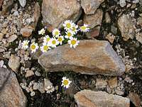 The beautiful flowers on the moraine of glacier Maurerkees.
No restrictions of climbing or fees although the whole area is part of the Nationalpark Hohe Tauern.
Camping is not allowed in the National Park, but alpine bivouacs are allowed.
Fee for crossing the Felbertauern-Tunnel € 10,00 in each direction. In the parking place in Streden you have to pay parking fee. For one day 3 euros, for whole week 9 euros.
Official site of Hohe Tauern national parc
When To Climb
January to May with Ski, July to September by foot. In summer time the huts are opened and you can get food almost as in a restaurant. The hut on the south side, Essener-Rostocker Huette, 2208m is opened the whole year.Camping and Huts
 A hut Essener - Rostocker, 2208m.
There are some camping places in the villages (Matrei,...).
The huts in the nearness are:
Essener-Rostocker Huette, 2208m.
Kuersinger Huettee, 2548m.