As all the mountains in the region South Tyrol/Bolzano Alto Adige, located near the boundaries between Italy and Austria, this peak has two names: Picco dei Tre Signori, the italian name, and Hoher Weisszint, the original tyrolese place-name. Picco dei Tre Signori (Dreiherren-spitze) 3499 m is one of the most famous and climbed peaks of the Hohe Tauern - Venediger Group, including Grossvenediger and Symonis-spitze. It is located on the boundary between Italy and Austria and it represents the highest mountain of the italian Valle Aurina (Ahrntal). The origin of the name is clear: when the name was formed, the peak was the meeting point of the borders of the earldoms of Goerz, Tyrol and the bishop of Salzburg. Since the First World War the name is true again for the Austrian states of Salzburg and (eastern) Tyrol and the Italian province Alto Adige / Suedtirol.
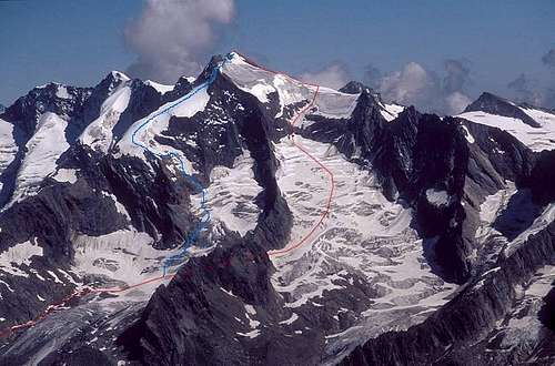
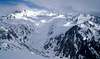
From the left: Dreiherrenspitze 3499m, Roetspitze 3495m and both Simony-Spitzen 3488m and 3440m
From the Italian side (West) it appears as an elegant pyramid of ice and rock, with a glacier smaller than the Austrian one (Umbalkees). The view is not so majestic from Austria, appearing as a snow ridge-line over the glacier. Crampons, ice axes and ropes are required and the levels of difficulty depend on the choosen route (ranging between PD and D). There is a third side of the mountain. To the Northern Krimmler valley the mountain has its almost upright 390 m high NE face with some routes up to UIAA V+ that are not repeated often because of their remoteness.
First ascent was done by Balthasar Ploner, M. Feldner and I. Feldner on November (!!) 2nd 1866. They were mountain guides and did the exploration for their client Dr. Wagl from Graz, who climbed the mountain with Ploner the following summer. Some writers report the first ascent throught the Austrian Umbalkees done in 1866 by Ploner (father and son) togheter with the guide M. Dorer from Pragarten. The first ascent from Italian side was in 1875 by T. Harpprecht and the guide S. Kirchler.
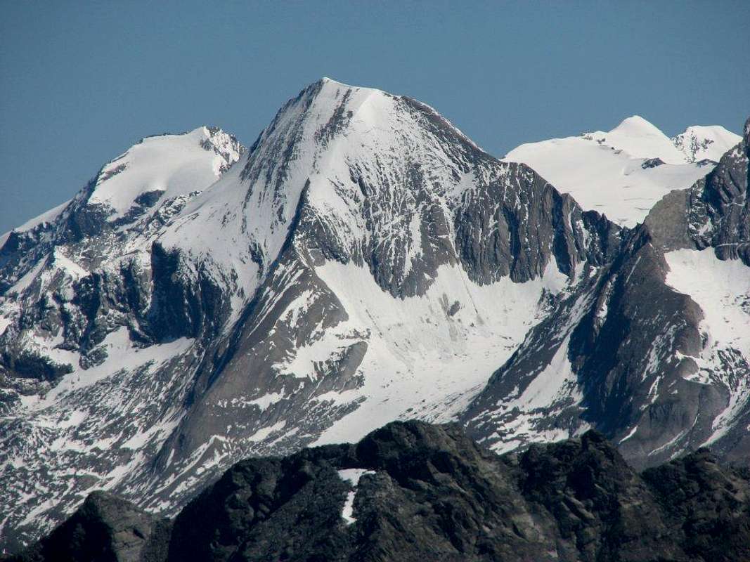
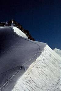
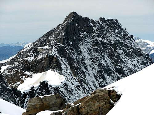
The mighty Picco dei Tre Signori / Dreiherrenspitze, 3499m from the west side.
Getting There
By car from Brunico/Bruneck (Val Pusteria/Pustertal) proceeds up to Casere/Kasern (1595 meters), the Northernmost village of Italy. A good alternative is an efficient public transportation service available from Brunico/Bruneck . If you have the car you are obliged to stop it at parking area in Casere from where the trails start.
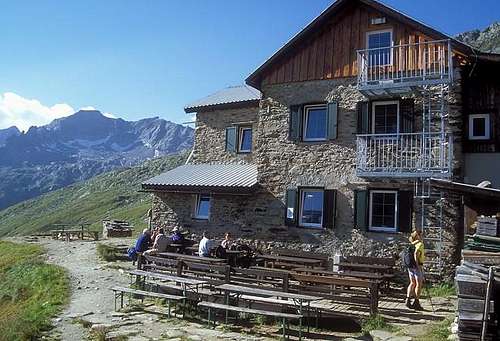
Two refuges are the starting points for Picco dei Tre Signori: A) Rifugio Tridentina (Birnluckenhuette), 2441 meters, 50 beds; B) Rifugio Giogo Lungo (Lenkjockelhuette), 2590 meters, 55 beds.
Route overview
Routes: Italian side
Routes: Austrian side
Scaling the west flank
There is a great variety of routes that have been climbed yet. But most of them esp. in the flanks are "old fashioned" – too difficult for normal climbers, too less difficult for sport climbers with loose rocks. Because of melting ice conditions may have significantly changed
Some routes that can probably recommended nowerdays are:
- SW ridge, normal route from Essener-Rostocker hut; PD; 5:30. hours
- SW ridge, normal route from Lenkjoechl hut; PD; 4:30 hours
- W-flank to SW-ridge, normal route from Birnluecken / Tridentina hut, via Prettaukees glacier – Lahnerschartl pass – Lahnerkees glacier; AD; snow/ice up to 48°; 4:30-5:30 hours
- NW ridge; AD; UIAA III; with traverse of the snow ridge called "Grasleitenschneid",
- E ridge, AD; UIAA III-; Maischberger, Gelmo, August 1902 - NE pillar; D; UIAA IV+, Peterka, Proksch, June 29th 1931; very difficult approach via the Krimmlerkees glacier
Here is briefly described how you can normally reach the summit of Picco dei Tre Signori from the Italian side (I never climbed it starting from Austria).
A1) FROM CASERE/KASERN TO BIRNLUECKEN HUT/RIFUGIO TRIDENTINA
Continuing along the Valle Aurina and following the stream Aurino (Ahrnbach). Easy but very beautiful walk in front of the Picco dei Tre Signori. 2:15-3:00. hours.
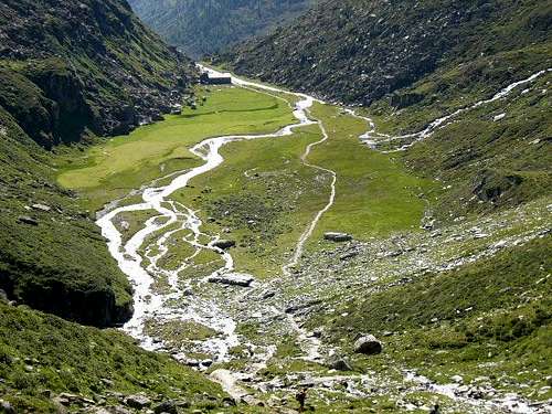
Lahner Alm pasture
A2) FROM BIRNLUECKEN HUT/RIFUGIO TRIDENTINA TO THE SUMMIT
Two main ascending routes. The most frequented (normal route) is classified as AD level (lecterature reports, in same cases, D level). Mainly on ice with a crux characterised by a steep slope of snow up to about 45° (or ice in advanced summer season). Generally the glacier is well marked as many climbers follows this route. Caution is required because of a grid of crevasses to be overcome before the slope (about 4:30-5:30 hours). The second one is harder with some rock slabs to be climbed with care and a very steep ice slope.
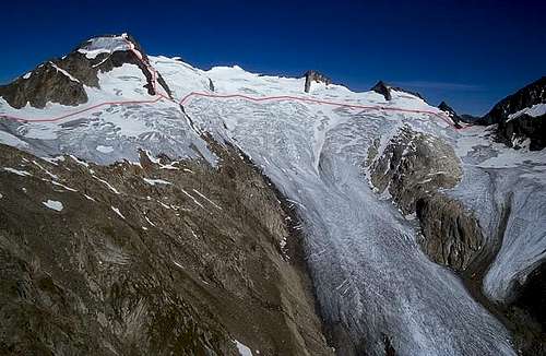
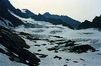
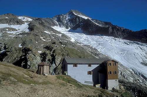
A2 route: Prettaukees glacier
B1) FROM CASERE/KASERN TO LENKJOECHL HUT/RIFUGIO GIOGO LUNGO
- By Valle del Vento/Windtal (most frequented as ascending route to the refuge; more confortable than the opposite Valle Rossa/Rottal) about 3:00-3:30 hours,
- By Valle Rossa/Rottal (very interesting route passing through an old copper mine; today it is possible to visit the galleries), 3:15-3:45 hours. I prefer this route descending from the refuge.
B2) FROM LENKJOECHL HUT/RIFUGIO GIOGO LUNGO TO THE SUMMIT
The normal route can be classified as PD level ((ecterature reports in same cases D level, maybe less when I climbed following this route). It is longer way than from Rifugio Tridentina (5:00-6:00 hours) with a long part on ice/snow ascending the Austrian glacier Umbalkees. Generally the glacier is well marked. Caution is needed when you have to overcome about 140 meters of a very steep slope of snow with possible snow cornices (it depends on the season). The difficulty of the normal route depends on the condition of the steep slope to gain the summit ridge. As long as there is still snow - that should be the case until August in normal summers - the tour can only be rated with PD.The final part of the route is the same as the normal route from Rifugio Tridentina.
Red Tape
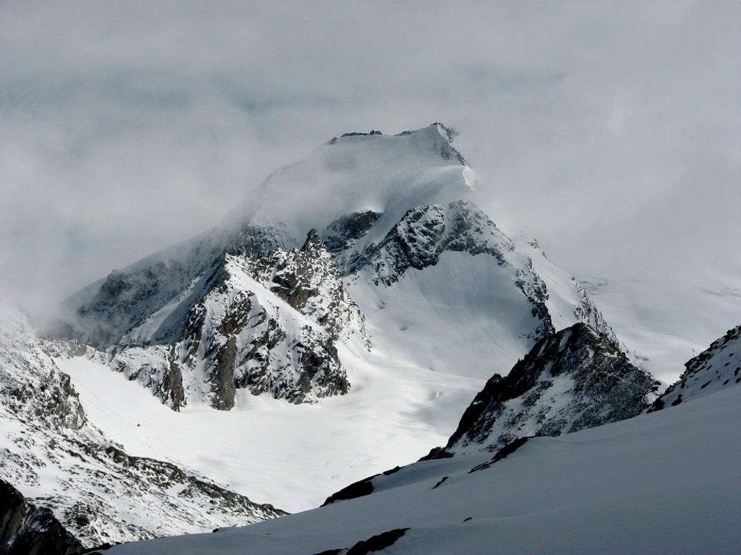
Picco dei Tre Signori / Dreiherrenspitze from the top of Simonyspitze
The huts are open from June-July to September in the summer season when most of climbers try to reach the summit.
Picco dei Tre Signori/Dreiherrenspitze is very often done as a ski tour. It is at least from the Austrian side very frequented. But the tour is quite long and passes also the upper plateau of Umbalkees, which is rich with crevasses. The tour starts from Essener-Rostocker Huette, 2208m. On the south the important hut is Clara Huette, 2038m.
Climbing the glaciers can be more difficult in later summer (from August) cause of the presence of hard ice instead of snow and, is some cases, the higher risk of stonefalls. In August 2007, from the Italian side (from Rifugio Tridentina) the ascent of the steep ice slope up to 3335 meters requested 1-2 ice-screws.
Situation: Forcella del Picco/Birnlückenhütte Open: from middle June to early October Size: 45 persons Guardian: Fam. Untergassmair Refuge's phone: +39 0474 654140 (private 0474 552217)
Along the route from Casere/Kasern to Rifugio Tridentina/Birnluecken are two other huts where you can rest and eat something: Kehrer Alm (1842 m) and Lahner Alm (1966 m). The last one is placed at the beginning of a wonderful pasture with the view of the Picco dei Tre Signori
Children refers to the set of objects that logically fall under a given object. For example, the
Aconcagua mountain page is a child of the 'Aconcagua Group' and the 'Seven Summits.' The
Aconcagua mountain itself has many routes, photos, and trip reports as children.
Parents refers to a larger category under which an object falls. For example, theAconcagua mountain page has the 'Aconcagua Group' and the 'Seven Summits' asparents and is a parent itself to many routes, photos, and Trip Reports.

 25596 Hits
 88.12% Score
 26 Votes