-
 11542 Hits
-
 80.39% Score
-
 12 Votes
|
|
Route |
|---|---|
|
|
36.56170°N / 118.224°W |
|
|
Trad Climbing |
|
|
Spring |
|
|
5.10c (YDS) |
|
|
6 |
|
|
III |
|
|
Overview
The Michael Strassman Memorial Route climbs the South Face of Lone Pine Peak following an impressive right leaning dike, dubbed the "Super Dike". This prominent feature rips across the otherwise blank wall for nearly 500 feet, offering up some incredible climbing along the way. The first ascent was accomplished on September 30, 2008 by Scotty Nelson, Charles Ince and Nate Ricklin.A video of Doug Robinson, SP Parker and Andrew Soloman climbing the Michael Strassman Memorial Route and releasing Mike's ashes into beautiful Sierra backcountry. Awesome tribute!
RIGHT HERE
Getting There
Approach Duration: 2-3 hoursThe following beta has been accumulated as a result of many years of bad
decision making while navigating through the Tuttle Creek drainage.....
*This approach can also be used to approach the Becky Route.*
Directions
After a few beers at Jake's Saloon in the town of Lone Pine head west on Whitney Portal Road. Follow this for a few miles to Horseshoe Meadows Road and hang a left (south). Follow this past a piece of the Alabama Hills for a couple miles or so to Granite View Drive and then go right (west). From here follow the gravel road for a while passing a lonely ranch house on your left. After passing the house go a couple hundred feet and look for an unmarked dirt road forking right. Follow this narrow road all the way to the trail head that leads to the Stone House.
High clearance vehicles will have no problem making it, lower clearance vehicles should be able to make it pretty close, if not all the way, with some creative driving. From here abandon your vehicle, grab your gear and make a break for the Stone House while following the nice trail, about 20-30 minutes. Once at the Stone House pay homage by looking out of all the windows and doors, take a picture or two, and talk about how great it would be to throw a party there sometime.
Approach
Getting started:
From the Stone House, head out of the north doorway which is choked with views of the South Face of Lone Pine Peak (SFLPP). Follow the path down from the Stone House for about 400 hundred feet (comes out to 100 hundred vertical feet). It is OK if you just cannot find the trail, wing a left in somewhere and go with it. Keep moving directly west while staying roughly level for about 100-200 yards before you start angling up (somewhat aggressively at times) through good trail, faint trail sometimes no trail. If you are on the right "trail" you should be passing several cairns and noticing some defined sandy switch backs. Please note that angling up too soon from the Stone House will lead to trouble and going too far down creates unnecessary work.
Cruising up the canyon:
If you lose the trail just continue to stay high by switch-backing up the sandy slopes. After awhile you will pass through a stand of large pine trees and a couple trickling streams. This is your last water source in the late spring/summer season and it is not very good.
The First Gully:
Follow the sandy trail along the side of the of the canyon (staying high) to the prominent loose, sandy, bouldery, gully (denoted as the First Gully in the aerial photo). Cairns will lead you across angling slightly up. If you have lost the trail and found this gully, follow it up until you find the cairns marking the correct location to cross. If you have gone too high in the gully it really turns into a mess, just bail to the right. If you crossed in the correct spot keep following cairns while angling up and crossing a few minor talus fields. Eventually, it will become hard to keep track of the trail so just keep traversing along the side of the canyon passing occasional
talus fields until you reach another bouldery gully that is much narrower, but still very noticeable (this is the Second Gully in the photo).
The Second Gully:
Follow this up a couple hundred feet. This is a pretty stable gully so use it to gain some elevation until cairns lead you out and right. If on track, you should be somewhat close to a massive north facing buttress.
Skirting the Boulder Field:
The trail is in good shape here and it will lead you up and around the massive boulder field that should be very visible off to your right. You can fight your way through the boulder field if you have lost your way it’s just not recommended.
The Flats:
While following the trail above the boulder field, it will begin leading you toward the SFLPP and large flat that is occupied by short brush and small pines. Take a look up to spot the Super Dike on the SFLPP for reference. The Ranch is down at the far east end of this flat and makes the best bivy site. Otherwise head toward the face and begin looking for the large brushy fan that is descending down out of a large triangular shaped buttress that is leaning against the SFLPP.

The final approach:
There should be two triangular shaped buttresses, the left one will be up the canyon a ways and the entrance is not visible. Keep making your way over until a deep sandy gully is reached. This is feature runs right along the base of the SFLPP toward the east. Cairns will mark the point where you traverse in. This feature is very easily crossed at the right spot, so make sure to find the cairns and faint trail. Traverse into the bottom and cross by climbing out next to a couple large boulders that look somewhat difficult to climb over. Once out of the drainage, a faint trail and washouts lead up the large brushy fan that comes out of the large steep gully. While staying left (along the SFLPP) follow the fan up until you become blocked by large boulders and then angle right into the center doing some minor bushwacking. A couple minutes of this leads to talus and then solid rock that is climbed at 3rd class with a couple moves of 4th near the top. Once at the top of the notch, look down below at the Stone House and then look up at the beautiful dike that is shooting across the SFLPP. Then rack up!

Route Description
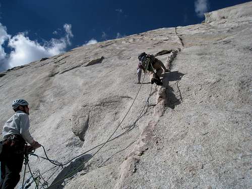
• P1 (5.7R): Climb the dike up the pedestal angling up and right toward a bush then follow the ramp up and left. At the top of the pedestal (sling horn for pro) traverse left into a left-facing corner that angles up and right. From here traverse right into a smaller ramp and head out across the face to a discontinuous dike that leads to a mantle then a roof and a belay. 50M.• P2 (5.10a): Climb up and right passing 4 bolts then get into the right facing corner. Climb this until it ends and move up and left passing a bolt then angling right toward a prominent ledge. 40M.
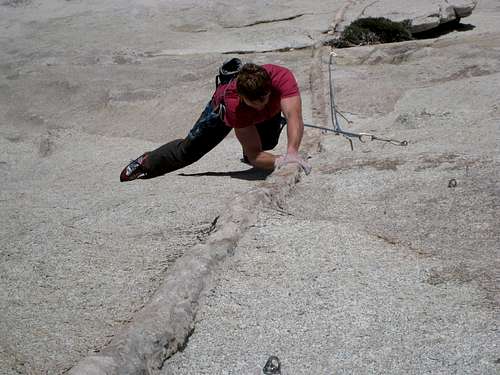
• P3 (5.10c): Amazing climbing follows the Super Dike. 55M.
• P4 (5.10c): Follow the Super Dike past a bush while doing some killer climbing along the way. 50M.
• P5 (5.10c): Continue on the Super Dike past 4 bolts into the ”Sea of Knobs” where the climbing becomes very easy. Look for the a 3 bolt anchor. This is where MSMR crosses Land of Little Rain (40M).
• P6 (5.4 X): AMAZING climbing (no protection) leads up and right through the ”Sea of Knobs” to a prominent bush and a 2 bolt rap station (35M).
If you are going to the summit, follow the Summer Ridge up and left.
Alternatively, from the top of P5 follow Land of Little Rain by going straight up and slightly left to a broken roof where a large crack will take you almost to the Summer Ridge (60M).
Follow the ridge and jump on the Direct South Face Route (Beckey Route)
to go to the summit. Otherwise, 2 ropes (60M) allow you to rap the MSMR
from the bush back down to the notch.
Topo and Gear
GET THE TOPO HEREImages of First Ascent