Introduction
This route is one of the easiest Grade V's in California. It is also one of the most enjoyable big walls in the High Sierra due to its relative ease and beautiful wilderness surroundings. Despite its original rating ( V, 5.7, A2 ), there is virtually no aid climbing except for one short tension traverse which also goes free ( A0 or 5.9 ). Weekend climbers wanting to test their skills on a long route will find this climb a great adventure. This is one of the longest walls in the High Sierra - over 3000'!
Approach
One needs the Lone Pine quadrangle map. From the town of Lone Pine, head west on the Whitney Portal road. Follow this to the Horseshoe Meadows road ( turn left , south ) and follow this road past the Tuttle Creek Campground Road to Granite View Drive. Turn right on Granite View Drive and head west , turning right at a fork past a house. Follow the well worn dirt road which ends on the south side of Tuttle Creek at about 6,800'.
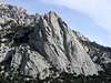
From the end of the road follow the trail on the south side of Tuttle Creek for a mile to the Stone House ( former headquarters for Warren Hardings " Low Sierra Eating, Drinking and Farcing Society " ). From the Stone House the climb can be seen about a mile futher upcanyon. Drop down towards the North Fork of Tuttle Creek a few feet from the Stone House and follow a climbers trail up the south side of the canyon. Depending on the route taken, this is either an easy hike or a sand and manzanita - filled hell. I recommend taking the use trail that stays as high as practical on the South side of the canyon. Two small seasonal stream are crossed by this trail. When the canyon steepens near the top of the large moraine , cross over a boulder field following ducks to the base of Lone Pine Peak. a prominent tower. An excellent bivouac cave can be found south of the creek bed near a prominent tower like boulder standing on end ( see photo showing cave ).
Route Description
Begin up a large long gully ( snow filled in early season ) which is behind an arete and ends behind a large prominent tower ( see photo showing route from the base and route topo ). A good bivy can be found on the wooded ledge on left side of the gully. Pitches 1 - 5: From the ledge at the gully's top, follow a right facing open book for 5 pleasant pitches. Pitches 6 - 10: climb a flakey crack to the right of a gully, then follow face and cracks for 4 pitches until one is forced to traverse left across the top of the gully. Pitch 11: climb a crack, then traverse left past a bolt to a belay in a large chute. Scramble 400' - 500' up and left up a gully and through a hole ( the Eye ) at the gully's top. Walk a few hundred feet right on ledges to a steep chimney leading to a gully. Pitch 12: starting left of the chimney, then face climb to a crack. . Climb to belay boulders. Pitches 13 - 16: climb up, then face climb ( 5.9 ) or tension traverse ( A0 ) right to a gully and belay shortly after. Continue for 2 pitches ( some loose rock ) to a belay on an exposed arete. Face climbing right leads to a crack and the end of the climb.
Descend the east slopes ( class 2 ) back to your car.
Essential Gear
165' ropes are a must, along with a standard rack of nuts up to 3". This route has the most comfortable bivy ledges you'll ever find, however, hauling a bag is not recomended due to the rough nature of the rock, and this climb can be done in a day. Water may be obtainable in the initial 1000' gully from snow melt in early season and later in wet years.
Misc.

 17040 Hits
 73.06% Score
 3 Votes


asmrz - Jun 23, 2005 6:58 pm - Hasn't voted
Route CommentThere are three exits to the upper buttress (from the Winter Route Notch). Since the chimney of the Beckey-Bjornstad route (after the tension traverse or 5.9) is extremely ugly off width climbing (especially with pack) two much cleaner (but bit harder) alternatives exist. The first one (and better one) goes straight up from the tension traverse on the B.B. route. Instead of tensioning (or 5.9) into the gully, climb the steep and great looking (5.8+) hand crack above. Full pitch of this gets you to the top of the buttress and 300 feet of scramblimg (4th) gets you to the plateau. The second variation goes from the same tension traverse point, but traverses left about 15 feet and climbs up on 5.8 face and arete for about 30-40 feet. Higher up, you reach 60-80 foot chimney which is about 3 feet wide, but incredibly smooth. Weird slittering up this (5.8) gets you to the same spot as the hand crack variation.
BTW. The South Face can be an incredible climb in winter. Leave your skis at the base to be picked up later and climb the route in the middle of winter. Since the route is South facing, it has sun on it even in mid winter. You might need crampons and ice axe, but the almost 3,000 foot wall is unforgetable experience in winter time. You might have to bivy on this one. Descent via the East Ledges back to Tuttle Creek.
Steve Larson - Jun 5, 2006 8:36 pm - Hasn't voted
Re: Route Comment"Weird slittering" that's great! You forgot to mention "no pro"! I ended up on this because we started in the wrong place on the upper buttress. Not being able to find the bolt at the start of the traverse was my first clue. This nasty gullet with a chockstone on top was unnecessary confirmation!
asmrz - Jun 19, 2006 3:20 pm - Hasn't voted
Route CommentsHi Steve: Sorry to respond this late, PC problems kept me off the air. There is NO BOLT at the start of the "tension traverse" (if that's what you describe in your post), the traverse is off a stopper in a crack about 8 feet above the start of the traverse. After the tension traverse, the leader climbs about 40-50 feet up a gully so the second can remove the pro and climb on "top rope".