
|
|
Route |
|---|---|
|
|
53.07206°N / 4.08005°W |
|
|
Hiking |
|
|
Spring, Summer, Fall, Winter |
|
|
Half a day |
|
|
Mostly easy walking which steepens markedly towards the end |
|
|
Overview
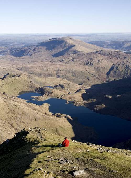
The Miners Track (approx 5.5km) is one of Snowdon's most popular routes, taking a relatively gradual approach around its northern lakes before rising steeply at Glaslyn where it joins the PYG Track and the Llanberis Path up to the summit. For the average walker and mountaineer alike it’s an extremely enjoyable walk combining spectacular views of Snowdon, Y Lliwedd, Crib Goch, Moel Siabod and the northern lakes, with a tour of the mountains industrial relics including the miner's barracks at Llyn Teyrn and the old mine buildings on the shores of Llyn Llydaw and Glaslyn. |
Getting There
The starting point for Miners Track is the Pen y Pass car park (SH 647 555) at the zenith of the Llanberis Pass, which can be reached easily by road on the A4086 that runs between Llanberis (SH 582 598) and Capel Curig (SH 719 580). Owing to the popularity and sheer number of routes that start here the Pen y Pass car park often fills up quickly so if you want to park there a very early start is recommended. Luckily there are other options, the first of these is an excellent park and ride which runs regularly all day (including weekends and bank holidays) from Nant Perris (SH 607 582). The second option is the Snowdon Sherpa bus service which has various stops around the mountain and runs from Llanberis, Bettws y Coed, Caernarfon, Beddgelert, Bethesda, and Porthmadog. Be sure to check timetables first as you don't want to end up missing the last bus and find yourself stuck, of course in these situations hitching is always and option. |
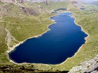 Llyn Llydaw Llyn Llydaw(Photo by Nanuls) |  Llyn Teyrn Llyn Teyrn(Photo by igneouscarl) |  Miner’s Track Miner’s Track(Photo by Nanuls) |
Route Description
The Miners Track begins at Pen y Pass and starts by contouring around the southeastern slope of The Horns. It follows the contours westward to meet the northern shore of Llyn Teyrn where it continues in a southwesterly direction around a small ridge. About half a mile after Llyn Teyrn the route reaches Llyn Llydaw, and it is here that one of the most majestic views of Snowdon can be seen, together with a full view of the mighty cliffs of Y Lliwedd on the left and the brilliantly red Crib Goch on the right. From here the track crosses Llyn Llydaw via its famous causeway, built in the 19th century to aid the transference of men to and from the mines on the far side of the lake and at Glaslyn. The path then follows the lakes shoreline for half a mile passing a number of derelict mine buildings along the way. The most prominent pf these is the old crushing mill of the Britannia Copper Mine which in its day was one of the most advanced mills in the country and was worked by a water-wheel fed from Glaslyn high above. At the last complex of ruins the path bears right and becomes steeper, roughly following the main stream that flows out of Glaslyn. On reaching Glaslyn the gradient eases for a short while as it follows the lakes eastern shore to another set of ruined buildings where it bears right once more becoming much steeper. From here the path climbs around 400m up to Bwlch Glas joining the PYG Track after some 120m along the way. This section of the route zig-zags up the southern slope of Garnedd Ugain before levelling out at Bwlch Glas where it bears left and joins the Llanberis Path along the final stretch to Snowdon's summit. |
Essential Gear
Just a good pair of boots, waterproofs and some lunch. If walking in winter make sure you also carry an ice axe and crampons. |
Maps
Guidebooks
| Snowdonia (Official National Park Guide) by Merfyn Williams The Mountains of England and Wales: Volume 1 Wales (Cicerone Guide) by John and Anne Nuttall Hillwalking in Wales Vol 1 (Cicerone Guide) by Peter Hermon Hillwalking in Wales Vol 2 (Cicerone Guide) by Peter Hermon Hillwalking in Snowdonia (Cicerone Guide) by Steve Ashton |


External Links
 Llyn Llydaw (Photo by Phillip Stasiw) Llyn Llydaw (Photo by Phillip Stasiw)Government Bodies and Official Organisations Snowdonia National Park Authority Association of National Park Authorities Royal Commission on Ancient & Historical Monuments in Wales Hiking, Climbing and Mountaineering Organisations and Companies British Mountaineering Council Plas y Brenin National Mountain Centre Weather Tourist Information North Wales Tourism Partnership Local Information from Gwynedd.com Local Information from Snowdonia Wales Net Travel Welsh Public Transport Information Accommodation Youth Hostel Association in Wales Maps and Guidebooks Cordee Travel and Adventure Sports Bookshop Wildlife and Conservation |