
|
|
Mountain/Rock |
|---|---|
|
|
42.76800°N / 109.198°W |
|
|
12482 ft / 3805 m |
|
|
Overview
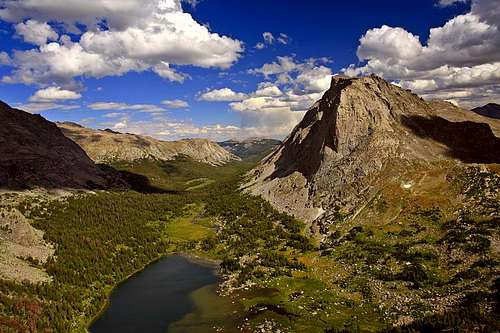
While Mitchell Peak doesn’t attract the same attention or unconsciously draw the eye in the same way as the jagged peaks of the Cirque of the Towers, its immensity dominates the eastern end of the Cirque above Jackass Pass, and it’s probably the most popular “walk-up” summit in the area. Its South Slopes, according to Finis Mitchell himself, “a ten year old kid could walk up”. Mitchell Peak, along with Dogtooth Mountain and Big Sandy Mountain form a high northwest-southeast ridge on the Continental Divide. The distinction between these points on the ridge is probably more apparent from the north, where enormous rock faces drop to the North Fork of the Popo Agie River. From Lonesome Lake, the 1000 ft North Face of Mitchell Peak gives this mountain a more inspiring appearance. This face had its first ascent in 1960 by a group including Yvon Chouinard and the amazing Fred Beckey, and this III 5.7 route is the easiest on this aspect of the mountain. From the summit one can see most of the major peaks in the range, including a great perspective on the Cirque of the Towers peaks and Lizard Head, and if you have good eyes as far as Fremont and Gannett Peak 30 miles to the north. The first recorded ascent in 1923 was via the South Slopes by mountains’ namesake, Finis Mitchell (1901-1995). Mitchell Peak from Pingora.
Finis Mitchell
A mountain is the best medicine for a troubled mind. Seldom does man ponder his own insignificance. He thinks he is master of all things. He thinks the world is his without bonds. Nothing could be farther from the truth. Only when he tramps the mountains alone, communing with nature, observing other insignificant creatures about him, to come and go as he will, does he awaken to his own short-lived presence on earth.- Finis Mitchell, from Wind River Trails
Finis Mitchell’s wandering, climbing, and popularization of the Wind River Range contributed significantly to the history of the range. A list of his accomplishments and contributions to the Wind River Range include hiking and climbing in these mountains in each of 9 decades during the 20th century. He climbed 'his' mountain (Mitchell Peak) at least 11 times, in addition to climbing hundreds of other mountains in the Wind River Range (apparently all but about 40 summits) making dozens of first ascents throughout the range, and experiencing the very rare privilege of having a mountain named for him while he was still alive. The naming of this mountain actually required an act of Congress. The mountain is visible from Big Sandy Opening where he started a fishing camp in 1929 that evolved into the current Big Sandy Lodge. There is a bronze commemorative plaque on the summit (the only such plaque in the range) dedicated to him.
Finis (rhymes with 'highness') came over South Pass with his family in a horse-drawn carriage to homestead. They homesteaded at Big Sandy opening. Finis moved to Rock Springs as an adult to work for the Union Pacific railroad. He stocked over a thousand lakes in the range by hand before state game and fish existed and before it was done by plane. If you catch a fish in the Winds, it's because Finis put it there. While hunting with his dad he climbed his first mountain and was hooked. Most of the walk-ups in the southern end and several in the northern are first ascents of his. He was the friendliest guy when you ran into him - and in his later years stood out because you don't usually see guys of that age in the deep mountains. The day I climbed 'his' peak I ran into him. He asked where we going and it was strange to say 'Mitchell Peak'! He absolutely loved to share the Winds with everyone and was an avid photographer (some say there are 70,000 photos). He would often travel around the state showing slides at student functions at the University, at regional Elks Clubs, etc. and could answer any question about every photo. That was his big deal, showing those slides to goups and politicians from Cheyenne. On the trail he would point out your rope and want to make sure you were being safe. Apparently, he prefered the walk-ups (the few that exist in the Winds) but jumped at the chance to go up peaks such as Gannett when a knowledgeable partner was present. His book has thankfully remained in print, is still the preferred trail guide, and is an entertaining read. (contributed by jimmyjay)
 Mitchell Peak (right) and Lonesome Lake.
Wind River Range
Wyoming’s Wind River Range runs southeast from its intersection with the Absaroka Mountains at Togwotee Pass to South Pass, where the Continental Divide yields to the rolling hills and sagebrush desert of the Great Divide Basin. Nearly the entire range is wilderness totaling roughly 1 million acres, without a single road crossing or even entering the entire range. This necessitates multi-day approaches for most peaks or climbs. The range contains 43 of Wyoming’s 50 highest peaks, including most of its thirteen thousand foot peaks. The range was deeply chiseled by glaciers during the Ice Ages, resulting in many steep-walled cirques and river valleys, as well as massive lakes such as Green River Lakes, Fremont Lake, and New Fork Lake where the glaciers pushed out of the high country into the surrounding plains. The glaciers still linger primarily on the leeward side of the divide in the northern part of the range, and are some of the largest remaining in the U.S. Rockies. Much of the rock in the range is solid granite and metamorphic providing abundant opportunities for rock climbing if you’re willing to undertake the approaches.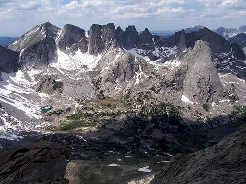 This is a view from the north ridge of Mitchell Peak looking into the Cirque of the Towers.
Getting There
Big Sandy TrailheadThere are several ways to reach this trailhead. All driving routes include much travel on gravel roads, but the gravel roads are generally in good condition and are passable by all cars in the summer season.
From the South
Option A
This may be the easiest route to follow, but I don’t know the exact mileage of the turnoff off highway 28. From Farson (~40 miles north of Rock Springs), leave US 191 and turn east on WY State 28.
Drive to just after South Pass and turn north on a road clearly marked for “Big Sandy Entrance”. If you reach the rest area along the highway, you have gone 0.6 miles too far.
Follow this good mag and gravel road north for 19.8 miles and turn right at the junction. Drive 5.5 miles along the signed road to a junction signed for the Big Sandy Campground.
*All options for the Big Sandy Trailhead share the route from here on. The road is also rougher from here on. Drive along this dirt and gravel road which becomes FS 850. Drive the main road 11 miles to the trailhead, ignoring the side roads to the summer homes and lodge.
Option B
This route is a bit harder to follow (take a good map), but is shorter and slightly rougher. From Farson, leave US 191 and turn east on WY State 28. After 4.6 miles turn left on a good road and keep straight for the first two junctions. After about 20 miles, there is a junction with a sign saying you can turn right to reach Big Sandy Entrance. Despite the sign, it is actually better to stay straight and at mile 33 from Highway 28, and turn right and drive another 7.1 miles to the junction signed for Big Sandy Entrance. Refer the paragraph with the asterisk for the rest of the route.
As mentioned, make sure to have a good map for this driving route.
From the East
This route shares the same access road as Option A above. From Lander, drive about 46 miles on Wyoming State 28 to a junction. This is 0.6 miles past the rest area and just before South Pass. From here, turn north on a road clearly marked for “Big Sandy Entrance”. The rest of the route is the same as the one described above for Option A.
From the North
From the north, drive about 12 miles south of Pinedale on US 191 and then turn east on Wyoming SH 353. Follow this highway for 18 miles to where the pavement ends and continue another 0.7 miles to a junction. Turn left then and stay right at the junction at 2.8 miles. Continue for 4.7 miles to another junction and turn left for another 7.1 miles to another junction. Refer the paragraph with the asterisk for the rest of the route.
Big Sandy Trail:
Follow the Big Sandy Trail about 7 easy miles to Big Sandy Lake. This lake is VERY popular, so don’t come here if you’re looking for solitude. The Lonesome Lake and Deep Lake areas also make popular base camps.
 This is the trail near Big Sandy Lake.
Little Sandy (Sweetwater) Trailhead
I haven't been to this trailhead, so can't comment on the condition of the road. It is said to be rough, but passable high clearance 2WDs and AWDs, though 4WD is preferable.
The route shares the same approaches ad the Big Sandy Trailhead, but is farther south. The route from the south will be the easiest to follow.
Use the same directions as "Option A" in "From the South" or the directions for "From the East". With a good map you should be able to make your way to the trailhead.
Dickinson Park Trailhead:
This trailhead is on the eastern side of the range. In the past 30 years, WR Reservation policy for the Dickinson Park Road has varied from a)open to the public b)open to the publc carrying a tribal fishing permit or c)closed to the public. It is currently (Sept., 2005) open without permit requirement. There is also a tribal outfitter working out of Mocassin Lake. If outfitted, you can use the Mocassin Lake trailhead which is the most direct access to Grave Lake and saves going over Bear Ears Pass. (contributed by jimmyjay)
To reach this trailhead, follow the unmarked but only paved road heading west from Fort Washakie. The road turns to dirt after a few miles and is rough, which makes for very slow driving, but it is still passable in 2WD vehicles. Follow this for about 20 miles to the trailhead at end of the road. Using this trailhead, the total distance to mountain is about 15 miles.
North Fork Trail: Follow the North Fork Trail for 13 miles as it drops into the deep valley of the North Popo Agie River and follows this valley until Lonesome Lake. This trail crosses the river 4 times, although only the third crossing is tricky (waist-deep with a fast current) in early summer.
Routes Overview
There are several routes available on Mitchell Peak, ranging in difficulty from class 2+ to difficult aid climbing.South Slopes
This is the easiest route on the mountain and is rated class 2+.
See the Route Page for details.
West Slopes
With careful routefinding, a class 3 route can be found accessing the northwest shoulder from Jackass Pass.
Northeast Slopes
This is a good snow climb early season and is also a good summer route. It is rated class 3 and follows the steep grass slopes above Lizard Head Meadows.
North Face Standard Route
This was the original route up the north face and is rated 5.7. See the route diagram for details.
 North Face of Mitchell Peak.
Other routes on the mountain are the North Ledge (Class 3-class 5), North Face Center-Ecclesiastes (5.9), North Face Right (5.8 A2), and the Northwest Face (5.10).
Red Tape
Mitchell Peak is located on the junction of the Bridger Wilderness in Bridger-Teton National Forest, the Popo Agie Wilderness in Shoshone National Forest. Standard wilderness regulations apply, i.e. no motorized vehicles, bicycles, etc. Camping is free anywhere in the backcountry, although camping within 100 yards of streams and lakes is prohibited and open fires are prohibited above treeline. The practice of low-impact camping techniques is critical in this extremely popular area. Water should be filtered or sterilized before drinking as some of these lakes have been found to be contaminated with human fecal matter. While there are no grizzlies in this part of the range (yet?), precautions should be taken to minimize encounters with black bears such as hanging food and cooking away from the area where you sleep. There have been recent maulings by black bears in this area due to poor camp hygiene.Camping
Vehicle Access CampsitesThere is a nice campground near the trailhead that usually has space on most summer weekends. The fees as of 2013 are $7 per night.
There are also many informal campgrounds within the national forest lands en-route to the trailhead.
Backcountry Campsites
There are many campsites between Big Sandy Entrance and Big Sandy Lake.
The most popular campsites along the approach are Big Sandy Lake and Cirque of the Towers. Because you must camp 200 feet from the lakes and 200 feet from the trails, campsites can be at a premium during holiday weekends.
Make sure to take proper bear precautions in all of these areas. Make sure to use low impact techniques, especially near or above timberline as the alpine areas are fragile.
When To Climb
Summer is the most common season for hiking, mountaineering, and climbing. While mountaineering and ski touring are possible in the winter and spring, the multi-day approaches and wilderness flavor make this a pursuit of only a hardy few. Expect plenty of other backpackers, horsepackers, and climbers in this very popular area. Summer also brings hordes of mosquitoes that will drive you crazy. They’re not as bad when you’re moving, but can make cooking and pumping water miserable. Mosquito repellant containing DEET is partially effective. By September the mosquitoes are mostly gone for the year. There is still a lot of snow in the high meadows in late June and early July, and this is the worst time for mosquitoes.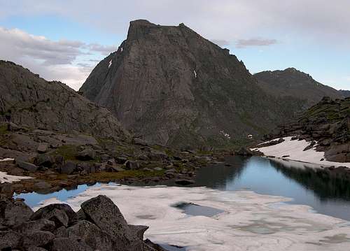 Mitchell Peak in August.
Mountain Conditions
Click Here For Area Weather ForecastBelow is the National Weather Service Climate Summary of South Pass City. The data is from 1915-2012. This is the closest long term weather station, but be aware that higher elevations will be much wetter and colder. South Pass City is at 7850 feet elevation, so expect the temperatures on the higher elevations of East Temple Peak to be 15-20 degrees colder than in South Pass City (except for cold winter nights).
| MONTH | AVE HIGH | AVE LOW | REC HIGH | REC LOW | PRECIP |
| JAN | 26 | 1 | 55 | -45 | 1.24 |
| FEB | 28 | 3 | 53 | -40 | 1.00 |
| MAR | 34 | 9 | 65 | -33 | 1.16 |
| APR | 45 | 20 | 75 | -22 | 1.40 |
| MAY | 57 | 28 | 83 | 0 | 1.54 |
| JUN | 68 | 34 | 89 | 6 | 1.28 |
| JUL | 76 | 40 | 91 | 18 | 0.86 |
| AUG | 75 | 38 | 90 | 15 | 0.88 |
| SEP | 65 | 30 | 84 | -5 | 0.99 |
| OCT | 53 | 22 | 80 | -26 | 1.03 |
| NOV | 37 | 11 | 62 | -30 | 0.91 |
| DEC | 28 | 3 | 55 | -46 | 1.06 |