
-
 7630 Hits
-
 79.78% Score
-
 11 Votes
|
|
Mountain/Rock |
|---|---|
|
|
28.94546°N / 13.77674°W |
|
|
Hiking, Scrambling |
|
|
Spring, Summer, Fall, Winter |
|
|
1440 ft / 439 m |
|
|
Overview
 Montaña de la Cinta as seen during the ascent from Yaiza Montaña de la Cinta as seen during the ascent from Yaiza |
Montaña de la Cinta, though only a low volcano, is one of the most important mountains of Lanzarote in the Islas Canarias. It is the home mountain of the village of Yaiza, above which it stands like a big broad sentinel. Its big time in history came, when Don Andres Lorenzo Curbelo, the parish priest of Yaiza, climbed it on September 1st 1730 to witness the first eruptions of what became one of the longest running volcanic ooutbreak in history: the Tmanfaya eruption.
Don Andres was the first eyewitness of a volcanic eruption to record his experiences. He kept a diary from the fateful day of Sept 1st until he had to leave the island about a year later. In his diary he describes how - step by step and blow by blow - the volcanoes of the Montañas del Fuego erupted and buried village after village beneath their lavas and cinder. On the Lanzarote Page I translated the first part of the diary. Here the famous first words might suffice:
”Today, on the first of September 1730, between 9 and 10 pm., the earth tore open near Timanfaya, two leagues from here.”
Montaña de la Cinta itself is much older than the Montañas del Fuego. It belongs to the mountain range Los Ajaches in the south of the island. This mountain range was one of the first - besides Risco de Famara in the north - to surface above the sea when Lanzarote came into being 16 million years ago. Consequently not much can be seen of the mountain's volcanic origin anymore. Together with Montaña El Cabo (396m) and Montaña del Medio (404m), Montana de la Cinta (439m) forms a trio of extinct volcanoes, perfectly aligned on one of the fault lines along which volcanism occurs on Lanzarote. The mountain itself is flat-topped but the final part of the ascent is extremely steep, making it one of the most "difficult" mountains on the island.
 |  |  |
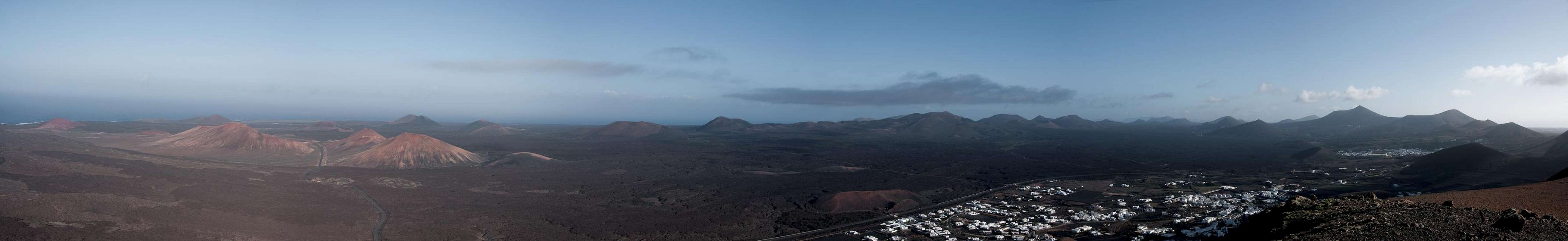
Don Andres Lorenzo Curbelo did right to climb it in order to observe the Timanfaya eruptions. Located south of the plain which is filled by the huge lava fields which were created by these eruptions, Montaña de la Cinta, together with Montaña de Guardilama to its north is one of the best lookout spots above the Montañas del Fuego. The southern view is blocked by Atalaya de Femes, the highest mountain of Los Ajaches. Thus, only parts of the neighbouring island Fuerteventura can be seen.
Summit Panorama: Las Montañas del Fuego
  |
Getting There
 Los Ajaches above Uga. Montana de la Cinta right of centre.
Though there are ferries from the Spanish mainland to the Canary Islands, they take more than 24h for the trip. Therefore most visitors therefore go by plane. Every travel agency in Europe offers flights, hotel rooms, apartments, rental cars etc. so that reaching the Canaries is rather a matter of money than opportunity. During the summer season flight fares can be reasonable but during the Easter and Christmas holidays you have to be prepared for additional fees of 500€ per person.
Lanzarote has its own airport between the capital Arrecife and one of the main tourist centres, Puerto del Carmen. There are public bus lines but – like on all the islands – they don't run too regularly. If you plan to stay on your own, better take a rental car right at the airport.
The best trailhead for Montaña de la Cinta is the village centre of Yaiza in the south-west of the mountain. The best itinerary (not the shortest but most impressive one) is as follows (the shortest one is simply to follow LZ2 from Arrecife to Yaiza):
- From Arrecife follow LZ20 through San Bartolomé.
- At the Monumento del Campesino turn onto LZ30 west.
- Drive through Masdache and ignore all intersections until you reach a roundabout.
- Take the first exit which takes you onto LZ2.
- After about 1 km you'll reach another ((huge!) roundabout. Take the second exit, which will take you into Yaiza. Park your car near the church.
Red Tape
Montaña de de la Cinta is located inside the Monumento Natural de los Ajaches which has been established to protect the barren mountain region Los Ajaches in the south of Lanzarote. Within the boundary of the natural monument the construction of new buildings is prohibited while the old ones can still be maintained. Also, part of the region is used for farming,, especially close to the villages and the whole range is used for sheep and goat grazing.Montaña de de la Cinta is made up from very brittle rock and scree. Please stay on the trails, especially on the last very steepp section, directly underneath the summit.
Accommodation
 Montaña del Medio and Montana de la Cinta with Yaiza
For holiday homes, hotels or apartments either consult your nearest travel office, or – search for lodgings on Google. There are several sites on the web, dedicated to rent privately owned houses or apartments. Prices are generally a bit less expensive than for tour operators but you don't have as much security.
Weather Conditions
Lanzarote, is usually swept by fierce north-western trade winds. Though they deposit their humidity on almost all of the other Canary Islands, Lanzarote is simply too low to form a decent obstacle. Therefore the climate is very arid. However, winds regularly are pretty strong,, especially on the mountaintops. It pays to take warm wind-stopping clothes with you.For some time of the year, eastern winds prevail, which almost always carry clouds of Sahara dust with them. Usually this means reduced visibility but in some occasions "Calima" occurs. Fierce storms take up the dust from the Sahara and sweep it across the islands. In these times visibility is nil and sometimes even the planes are grounded.
Maps & Books
Maps
Regular Maps
- Lanzarote
Kompass Map WK241
Kompass Verlag
1:50000
ISBN 3-85491-175-0
Digital Maps
Kompass is the only company known to me which offers GPS digital Maps. In addition for those of you with Garmin GPS receivers there is a map source map set of all Canary islands out there.
- Lanzarote
Kompass GPS4241
Kompass Verlag
ISBN 3-85491-223-4
- Islas Canarias
Map Source custom map
By Manfred Pepper
downloadable zip-file
Books
My recommendation is a guidebook by Rother Verlag, available in German. The book is an excellent hiking guide covering all the interesting areas of the island. Since it comes with small maps for each excursion it might even be used without a map to support them.
- Lanzarote
Rolf Goetz
Rother Verlag
ISBN 3-7633-4302-4