
-
 56896 Hits
-
 96.25% Score
-
 58 Votes
|
|
Area/Range |
|---|---|
|
|
29.02892°N / 13.62487°W |
|
|
Hiking, Scrambling |
|
|
Spring, Summer, Fall, Winter |
|
|
2205 ft / 672 m |
|
|
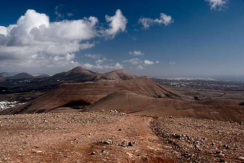
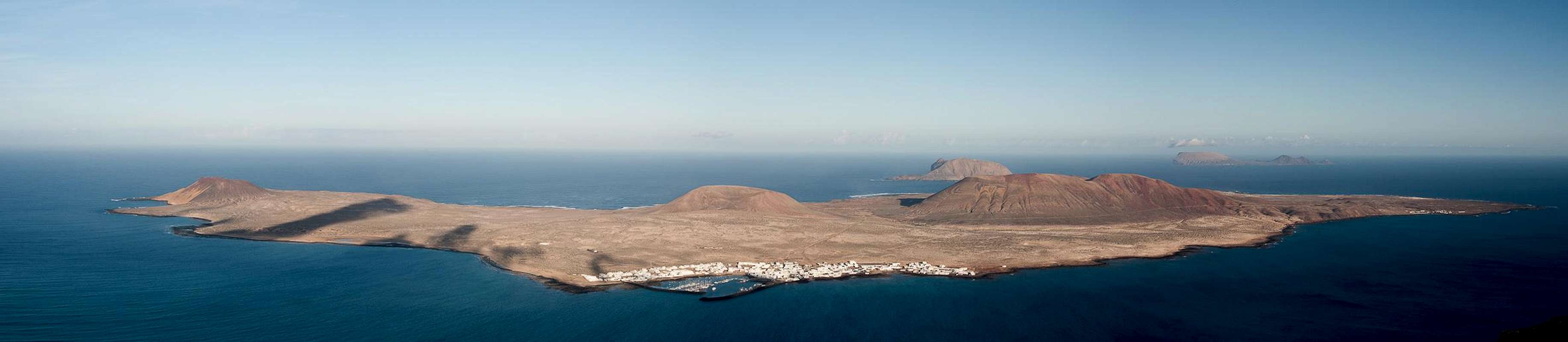
1 - Isla del Fuego - the Island of Fire
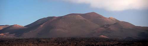 Montaña Timanfaya, epicentre of the 1730 - 1736 eruptions on Lanzarote Montaña Timanfaya, epicentre of the 1730 - 1736 eruptions on Lanzarote |
1.1 - Overview
Lanzarote is both the northernmost and easternmost of the Canary Islands off the coast of Africa. It is located some 100km from the Moroccan coast at 29°00' north, 13°40' west. With roughly 850 square kilometres it is the fourth largest of the Canarias but at a mere 672m in height it is also the lowest of the seven big islands. Moreover, its highpoint, Peñas del Chache, is off limits thanks to a military radar installation on its very top. You might be tempted to ask why this island appears on a mountaineering site but the geology of Lanzarote can tell us a lot about the formation of mountains by volcanism and erosion.
All the Canary Islands are of volcanic origin and Lanzarote is the one least able to conceal it. I invite you to take a look at the interactive map of the island. Be sure to switch to the hybrid mode and you'll be sure to distinguish hundreds of volcanic craters, especially in the west of the island. Though one of the oldest of the Islas Canarias, most of Lanzarote's craters have formed fairly recent. The most recent eruption was in 1824 but the bulk of the volcanoes has been formed in the last 3000 – 5000 years. They have been admirably been preserved by Lanzarote's dry climate, so that even today, lava fields like the Malpais de la Corona, which dates back 5000 years, look like the much younger fields on Tenerife or La Palma.
Weather – or the lack of it – is a major issue on the island. Though swept by the same trade winds, which deposit so much humidity on the western Canary Islands, Lanzarote is simply too low to be affected by them. Water is scarce and without desalination plants tourism would virtually impossible. Flora and fauna have adapted admirably in these desert like conditions so that after a day of rain suddenly whole fields of colourful flowers appear out of nowhere. There are several regions on the island, where this never happens, the most important one being the Montañas del Fuego, the Fire Mountains in the Timanfaya National Park.
1.2 - Timanfaya
  |
”Today, on the first of September 1730, between 9 and 10 pm., the earth tore open near Timanfaya, two leagues from here.”
Thus begins the diary entry of Don Andres Lorenzo Curbelo, the parish priest of Yaiza, a village in the south-east of Lanzarote, which deals with the longest historical eruption on the island.
“A huge mountain formed in the first night already and flames shot out from its summit, burning for 19 further days. A few days later a new crater emerged and the lava flowed across Timanfaya, Rodeo and parts of Mancha Blanca. The Lava flowed towards the north, at first like gushing water, later viscous like honey. But on Sept 7th a huge rock rose out of the earth with an ominous rumble, forcing the lava to flow west and north-westward. There it destroyed Maretas and Santa Catalina.
On September 11th the activity of the lava renewed. It covered and burned Mazo whereafter for eight days a fiery cataract plunged into the sea with a fearful roar. Huge amounts of dead fish floated on the surface and were thrown upon the coast. Afterwards everything calmed down and the eruptions ceased.
But on October 18th three new craters opened up directly above the burned Santa Catilina, spilling huge clouds of fumes, which covering the whole island with sands and ashes. The gloom they produced repeatedly forced the people of Yaiza to leave their village."
Timanfaya used to be a village in the fertile south-west of Lanzarote, which during the first onslaught got buried by cinder and lava. 12 more villages were to follow, taking with them 420 dwellings into oblivion. Some of today's volcanoes are named after the villages but apart from this no trace remains. The eruptions lasted for 5 ½ years until April 1736 making this eruption one of the longest eruptions in recorded history. The lavas covered an area of almost 200 square kilometres or roughly one fourth of the island's area. The island's boundaries were extended in the north where lava streams formed a wild new coastline, impressive even still today. No humans died, most likely because these eruptions had been preceded by years of quakes and rumbles.
Of these 200 square kilometres one fourth, 50 square kilometres around the epicentre of the 1730 eruptions have been set aside as a national park, the Parque Nacional de Timanfaya. Except for a few (four) places the park is strictly off limits for any non scientist. The dry weather of Lanzarote ensures that colonisation of the lavas by plants and animals occurs in super slow motion. In the last (almost) 300 years only different varieties of lichen have gained a foothold, making them the first pioneers in a hostile environment. Actually the lichens have been very successful: 200 different types have been counted from which no more than 80 have been scientifically classified. However the time it takes for this kind of colonisation is immense; a ranger showed us a place where a car had driven off-road more than a decade ago. You were still able to see the tracks, where the lichen population had been destroyed.
The four activities you can perform in Timanfaya National Park are:
- Ruta del Litoral, a path through the malpais along the northern coast. It is a 9km trail, which you can explore on your own – the only such activity. 9km through the malpais (“badland”, the towering lava fields) can take a whole day to hike.
- Timanfaya Guided Tour. It is a once in a lifetime chance to take part in such a tour. You have to apply at least three weeks before the desired date and only people older than 18 and younger than 70 qualify. Each day 16 persons can take part in one of the tours, which is why your personalia are taken before the start. The tour is a 5km, 2h hike through the westernmost part of the park. You are guided by qualified and very engaged park rangers.
- Ruta de los Volcanes, Islote del Hilario. This is the most popular of the tours. For a fee of 8€ per person you can drive inside the park to a place, called Islote del Hilario. The place – an “island” which never was covered by the lavas of the eruptions – is nevertheless the hottest spot in Lanzarote. Guides perform a couple of stunts like kindling fire from the heat of the earth or producing geysers by pouring buckets of water down tubes which lead into the hot ground. In the place an restaurant has been erected, where food is barbecued on a “volcano grill”. From Islote del Hilario you can take a bus ride along the Ruta de los Volcanes, a paved road, which leads through the epicentre of the eruptions. While not an outdoor activity, it is still recommendable – if you are prepared to pay the fee.
- Dromedary Riding. This is the ultimate tourist attraction. There are currently 210 dromedaries which take the tourists up a 500m – 1km loop into the Montañas del Fuego. Not overly interesting, imho.
To get an overview over the Montañas del Fuego, I can recommend Montaña de la Cinta to the south-west of Yaiza, the mountain from which Don Andres Lorenzo Curbelo observed and recorded the eruptions.
2 - A Short Geological Overview
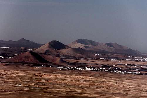
 Caldera Rajada (176m), Montana Rajada (373m)
Lanzarote, after neighbouring Fuerteventura, is the second oldest of the Islas Canarias. 36 million years ago the foundations of both islands were created in the area where two tectonic plates, the Atlantic and the North-African ones, collide. The Atlantic plate being younger and less solid, breaks up whenever there is movement, opening the bowels of the earth to free lava. Thus Fuerteventura reached the ocean surface some 20 million years ago while Lanzarote followed 16 million years ago.
At first the Famara and Ajaches mountains in the far north and far south of Lanzarote formed as two separate islands, after which volcanic activity subsided and the islands lay dormant for several million years. Erosion sculpted the regions, which sets them apart from the remainder of the island today.
 Caldera Blanca, the largest crater on Lanzarote
Then – about 5000 years ago – volcanic activity renewed, creating the long chains of volcanoes in the south-east and north of the island. On Lanzarote, like on Tenerife or La Palma, volcanic activity occurs in the form of cleft volcanism, where craters develop along a fault line. Thus, today you'll find the volcanic cones aligned like the pearls on a string. Again, I encourage you to look at the interactive map to observe this alignment. The most important eruption during that time was the one of Monte Corona on the Famara peninsula, which covered the whole north of the island with lavas, extending the boundaries on the coasts. The eruption occurred from four craters, La Quemada de Orzola, Monte Corona, Los Helechos and La Quemada de Maguez. In what must have been an impressive sight, a lava flow poured down the 500m high Famara Cliff like a waterfall of liquid rock. During that time, also the islands of the Archipelago Chinijo were formed.
The last phase, after two millennia of tranquillity, were the eruptions of 1730 and 1824, which formed the Montañas del Fuego. Again, volcanoes formed along a fault line, but this time the eruptions were so fierce that craters developed to both sides of the fault. Today, a huge sea of solid lava covers the soil, a quarter of which is protected by the Timanfaya National Park, while the remainder belongs to the Parque Natural de los Volcanes.
3 - Lanzarote on SP
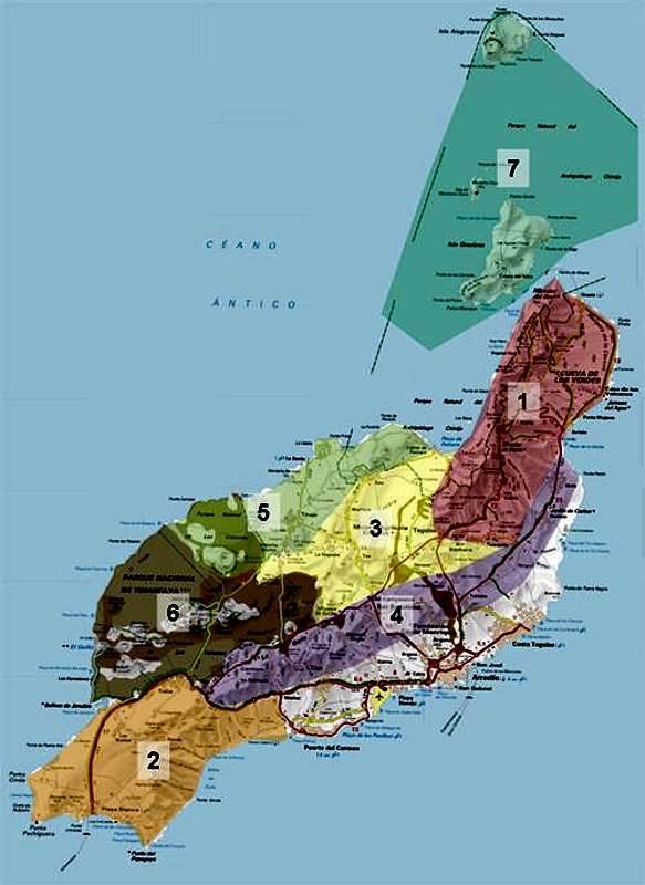 |
Currently none of the volcanoes on Lanzarote are on SP. However, the above map and the links below direct to the respective sections on this page. Apart from the two oldest areas of the island, Risco de Famara in the north and Los Ajaches in the south, Lanzarote does not have any mountainous regions. Rather there are a lot of hill-like volcanoes which are all aligned along the fault lines of clefts, where volcanism took place. The three longest and most important of these chains are accounted for by three sections on this page. Finally, to the north of Lanzarote you will find the islands of the Archipelago Chinijo, which also are accounted for in one of the sections below.
- Risco de Famara (overview)
Risco de Famara (separate page) - Los Ajaches
- The Teguise Plain
- The San Bartolomé Chain
- The Tinajo Chain
- Las Montañas del Fuego (this page)
Las Montañas del Fuego (separate page) - Archipelago Chinjo
4 - Risco de Famara
 |
The oldest part of Lanzarote can be found in the north of the island. It is named after the village and beach of Famara, located at Bahia de Penedo, the bay, which is plainly distinguishable to the west of the peninsula. The most important feature is Risco de Famara, a massive cliff of some 15km length and a height of up to 672m. Lanzarote's highpoint, Peñas del Chache, is also the highest point of this cliff. While easily reachable from its eastern side Risco de Famara drops with an average drop of 500m vertically into the sea to its west. The rock is solid basalt in its topmost part only while approximately 80% of the cliff is brittle and rotten. Thus there are no climbing routes here. For hikers there are two interesting alternatives: an exposed hike along the break-off ridge and an abandoned mule road cutting through the cliff at half height. The road was abandoned due to rockfall and nowadays has some challenging sections.
Apart from Risco de Famara, the peninsula also carries the craters of four volcanoes, the most important of which is Monte Corona. About 5000 years ago it erupted covering most of the western part of the peninsula with its lava, the Malpais de la Corona. It hosts a number of long lava tunnels, the best known of which are Cueva de los Verdes and Jameos del Agua.
5 - Los Ajaches
 Los Ajaches as seen from Montaña de Guardilama
The southern counterpart to the Famara Peninsula is the southern peninsula around the beach resort Playa Blanca. Most of this part of the island is a flat desert-like plain but to its east the second oldest part of the island rises: Los Ajaches. Naturally all are of volcanic origin, though for most of the mountains it is not immediately obvious. The highest and most popular of the mountains is Atalaya de Femes, which unfortunately carries a forest of antennas on its top. However, it is famous for its views of the Montañas del Fuego and the neighbouring island of Fuerteventura.
Right to the north of Atalaya de Femes, separated by Valle de Fenauso, there is the historically important summit of Montaña de la Cinta. From this mountaintop, the home mountain of Yaiza, Don Andres Lorenzo Curbelo, the parish priest of the village witnessed the historical eruption of 1730. His diary is the first detailed eyewitness account we have of any volcanic eruption.
The Ajaches Mountains are very barren. Since it never rains on Lanzarote and the south-west of the island is even drier than the other parts, you can find only the hardiest of plants here. Still the area is used for extensive goat grazing and somehow the flocks seem to miraculously survive. The mountains are cut through by deep barrancos which end among some quite impressive cliffs near the sea.
6 - The Teguise Plain
 Guanapay with Castello de Santa Barbara
Teguise, the old capital of Lanzarote is surrounded by what one would call high plateau – if its height weren't just about 300m only. Basically this plain is the only part of the island where you can't find any volcanoes currently. Teguise's home mountain, Guanapay, already belongs to the Famara peninsula.
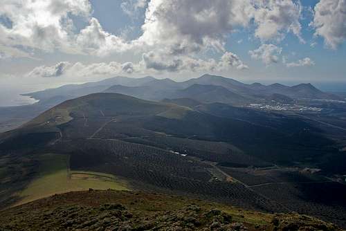
7 - The San Bartolomé Chain
 The San Bartolomé Chain
Along the eastern coast of he island you can find the longest of the volcano chains. The fault, which broke up about 5000 years ago, runs from Arieta in the north to Uga in the south. Activity was highest in the south, where between San Bartolomé and Uga the highest volcanoes have formed. The northern volcanoes are barren while the southern ones are often used for farming. Their craters offer a natural protection against the high winds that sweep the island.
The slopes of the highest volcano, Montaña de Guardilama, are covered with hundreds of little man-made pits, which contain one or two wine plants. They are covered with lapilli – volcanic cinder – a natural conserver of humidity. Finally each pit has been surrounded by wind-stopping walls. It is here that Lanzarote's biggest and oldest (and for that matter Spain's oldest as well) wineries are located.
8 - The Tinajo Chain
 Montana Timbaiba, (339m), Montana Tinache (542m), Caldera Blanca (458m) and Risco Quebrado (312m)
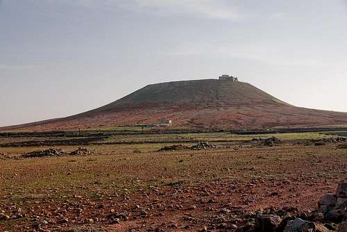
An equivalent to the south-eastern San Bartolomé Chain is the northern Tinajo Chain, which runs westward from Bahia de Penedo near Caleta de Famara in the east across Tinajo and Mancha Blanca. Its westernmost summit, actually a volcano trio (Montaña Caldereta, Caldera Blanca and Risco Quebrado) is already located within the Parque Natural de los Volcanes. Like the San Bartolomé mountains, this chain also was formed during eruptions, which took place 3000 – 5000 years ago. But due to the aridity of the region, no farming has taken place yet.
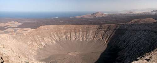
Caldera Blanca is of special interest. The 458m high crater is Lanzarote's widest one: it measures 1.15 km across. It is located within the area, which was covered by the Timanfaya eruptions in 1730 – 1736 but forms an island among the sea of black lava. Moreover, it is one of the few mountains, which may be climbed in the area. From its top – especially in the early mornings and late afternoons you get good close—up views of the Montañas del Fuego in the south.
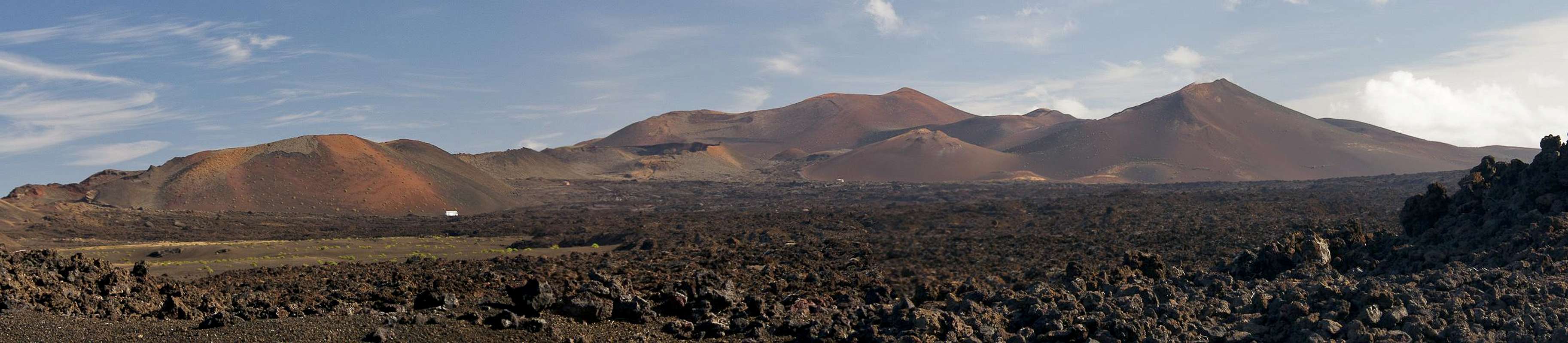
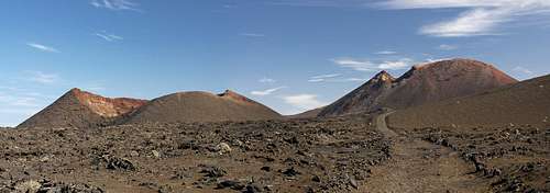
9 - Las Montañas del Fuego
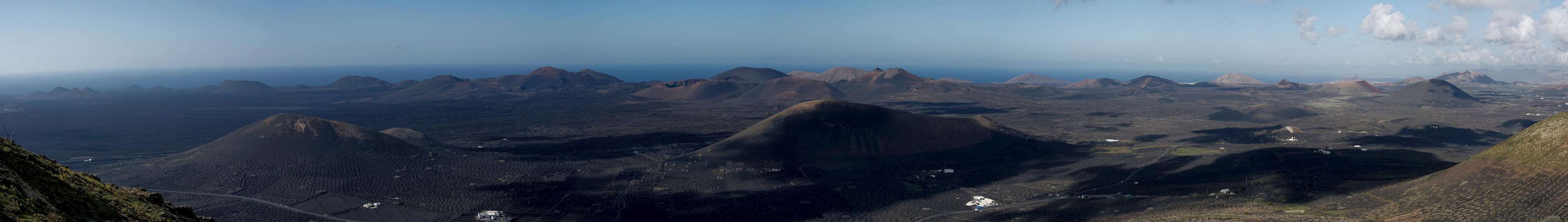 |
The main attraction of Lanzarote is the volcanic chain of the Montañas del Fuego. These are the mountain, which erupted in 1730 through 1736. Also, the 1824 eruption took place here. A look at the interactive map below reveals the origin of this chain. A fault line opened beneath the surface preceding the 1730 eruption along which magma rose to the surface. After years of quakes finally at the site of the vanished village of Timanfaya – visible on the satellite map left of LZ67 – the first and most violent eruption took place, eventually piling up Montaña Timanfaya, the highest summit of the area.
|
The Montañas del Fuego take all the area between El Golfo in the west (half of it's crater has already eroded by sea tides) and Masdache in the east. The last of the volcanoes to erupt was Caldera Colorada, the crater of which shines brightly red when seen from the east. The Montañas del Fuego covered about 200 square kilometres of the island with their lavas. Out of these “seas of lava” occasionally older volcanoes rise like islands, Caldera Blanca or Montaña de Vieja Gabriela being the most important ones.
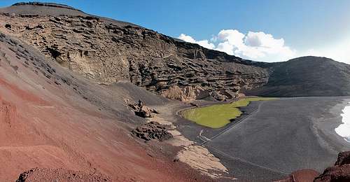 Montaña del Golfo with its green lagoon
The Montañas del Fuego have been protected in their entirety either by the Parque Nacional de Timanfaya and the Parque Natural de los Volcanes. For more information about the parks see the Red Tape Section.
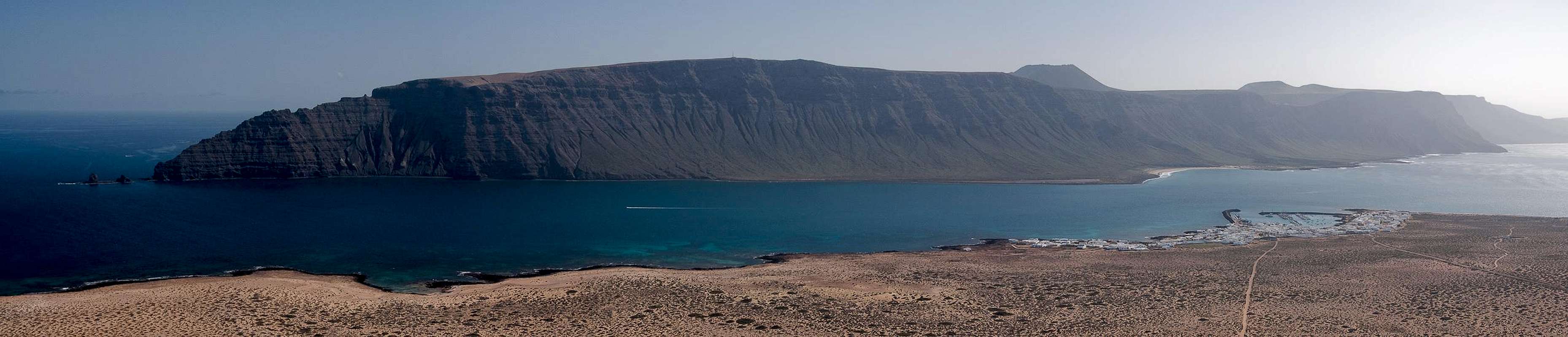
10 - Archipelago Chinjo
 |
Strictly speaking, the Archipelago Chinijo is not part of the island of Lanzarote but rather a set of a handful of islands to its north. Together with Risco de Famara on Lanzarote, they have been protected by the Parque Natural del Archipelago Chinijo. Like Lanzarote the islands are of volcanic origin. Though very little is known about their geology most likely they were created during the second phase of volcanic activity on the main island between 3000 and 5000 years ago.
Of the five islands of the Archipelago Chinijo, only the largest one, La Graciosa, is inhabited permanently. There is a harbour, Caleta del Sebo, to which a ferry from Orzola in the north of Lanzarote, sails three times a day. La Graciosa is a flat desert island, above which four volcanoes rise. The highest one, Montaña Pedro Barba, is a twin peaked (and cratered) volcano at 266m. Next in size is Isla de Alegranza, located to the far north of the archipelago. It contains three volcanoes, the highest of which is Montaña de Alegranza, at 289m also the highest one of all the islands. With a diameter of 1.1km it is also one of the largest craters of the Lanzarote / Chinijo Complex. Isla de Montaña Clara is the third largest of the islands, located between La Graciosa and Alegranza. Its mountain is 256m high, a volcanic crater the north of which has already vanished below sea level. Roque del Este and Roque del Oeste, the remaining two islands, are not more than small rocks. They are also of volcanic origin but are visited very rarely.
11 - Traffic and Accommodation
Though there are ferries from the Spanish mainland to the Canary Islands, they take more than 24h for the trip. Therefore most visitors therefore go by plane. Every travel agency in Europe offers flights, hotel rooms, apartments, rental cars etc. so that reaching the Canaries is rather a matter of money than opportunity. During the summer season flight fares can be reasonable but during the Easter and Christmas holidays you have to be prepared for additional fees of 500€ per person.
Lanzarote has its own airport between the capital Arrecife and one of the main tourist centres, Puerto del Carmen. There are public bus lines but – like on all the islands – they don't run too regularly. If you plan to stay on your own, better take a rental car right at the airport.
As for holiday homes, hotels or apartments either consult your nearest travel office, or – search for lodgings on Google. There are several sites on the web, dedicated to rent privately owned houses or apartments. Prices are generally a bit less expensive than for tour operators but you don't have as much security.
12 - Red Tape
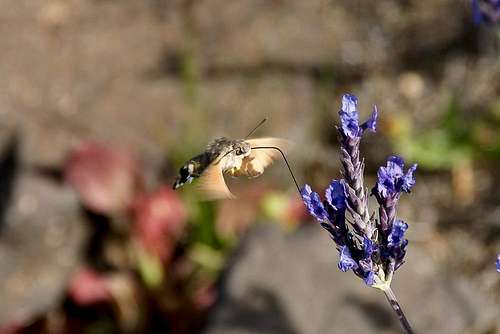 Macroglossum stellatarum
Everywhere on the Islas Canarias tourism changed the way of living - often for the worse but almost as often for the better. The local authorities soon found out that what attracted the tourists to the islands where not only the beaches but also the unique landscape and environment. Thus everywhere National and Regional Parks have been created. The National Parks, of which Lanzarote has only one, the Parque Nacional de Timanfaya, are strictly protected. Only a limited amount of activities may be done, the list of which (for Timanfaya) can be found in the opening section of this page.
On the other hand, on each island you can find a differing number of natural parks, which often form a patchwork of natural sites around the towns and villages on the island. These parks restrict the ancient rights, the locals have and in many cases have been very tough to inaugurate. On Lanzarote the big issue were Lapilli, the volcanic cinder, which the local farmers use for covering their fields. Until the creation of the natural parks, locals used to pick lapilli, wherever it suited them best. A good example is Caldera Santa Catalina in the Parque Natural de los Volcanes. Here Lapilli digging was industrialized with a rather big quarrying site, several square kilometres across. The natural park restricted quarrying and now the place is left to its own. Instead, each municipality has its own digging site, which is the only place lapilli quarrying is allowed.
The following is a list of Lanzarote's natural sites:
Parque Nacional de Timanfaya - protecting 50 square kilometres of the Montañas del Fuego
- Parque Natural de los Volcanes - placed like a half circle around the TimanfayaPark, together they cover the whole area of the 1730 - 1736 eruptions
- Parque Natural del Archipelago Chinijo - encompasses the five islands of the archipelago Risco de Famara in the north of Lanzarote. Also the eastern part of the Tinajo Chain belongs to this park
- Monumento Natural de la Corona - encompasses Monte Corona and the Maplpais de la Corona in Lanzarote's north
- Paisaje Protegido de Tenegüime - Preserve to the west of Guatizza in the north of Lanzarote
- Monumento Natural de la Cueva de los Naturalistas - small natural monument in the centre of the island around a lava cave
- Paisaje Protegido de la Geria - Preserve, which contains the wine growing region of La Geria
- Monumento Natural de los Ajaches - Natural park in the south-east of Lanzarote, containing the Ajaches Mountains
13 - Weather Conditions
Weather is a major issue on Lanzarote. Though it is located in the trade wind zone like the other Canary Islands it is simply too low to take advantaage of the humidity, which the clouds deposit everywhere else above 1000m. Therefore you have a desert climate on the island, which only in winter can be interrupted by a day of rain. Like in any other desert these rains can be torrential!
The plants of the island take their humidity out of the dew, which drops every morning onto the plain.
Occasionally – several times a year – the severe climate of “Calima“ occurs. Fierce eastern winds or storms pick up dust in the Sahara and take it with them far over the Atlantic Ocean. In days like that visibility on Lanzarote can drop to several hundred metres. In summer temperatures of up to 40° C can occur. Calima weather can last several weeks but affects only elevations beneath 300m. Above visibility quickly gets better while temperatures can drop dramatically.
14 - Maps & Books
14.1 – Regular Maps
- Lanzarote
Kompass Map WK241
Kompass Verlag
1:50000
ISBN 3-85491-175-0
14.2 - Digital Maps
Kompass is the only company known to me which offers GPS digital Maps. In addition for those of you with Garmin GPS receivers there is a map source map set of all Canary islands out there.
- Lanzarote
Kompass GPS4241
Kompass Verlag
ISBN 3-85491-223-4 - Islas Canarias
Map Source custom map
By Manfred Pepper
downloadable zip-file
14.3 - Books
My recommendation is a guidebook by Rother Verlag, available in German. The book is an excellent hiking guide covering all the interesting areas of the island. Since it comes with small maps for each excursion it might even be used without a map to support them.
- Lanzarote
Rolf Goetz
Rother Verlag
ISBN 3-7633-4302-4
- Lanzarote