
-
 5923 Hits
-
 75.81% Score
-
 6 Votes
|
|
Route |
|---|---|
|
|
46.53392°N / 13.31625°E |
|
|
Hiking, Scrambling |
|
|
Summer, Fall |
|
|
Half a day |
|
|
A demanding hike |
|
|
Rating the Route (By Hiking Standards)
Monte Brizzia view
The grading system for hiking and scrambling routes is here.
0. General: From 900 m to 1583 m, several ups and downs. Exposition W, S and E. Military paths are ruined on several places, and also the new protection devices (chains) were in 2010 on several places destroyed and only of a limited help. By the Swiss (SAC) Hiking Scale the rating would be T4 (the trickiest passages), otherwise mostly T2. Ascent on Monte Bruca (fore-summit) is a bit more exposed and requires a short passage of an easy climb (UIAA I) over lose rocks. Gear: Good shoes and poles.
1. Effort: cca 950 m, 5 h for the round tour.
2. Power: 3 - Medium hard (easy climbing).
3. Psyche: 4 - Hard. Several passages with not good protection devices, ascent on Monte Bruca (fore-summit) is on the border of an easy climb (UIAA I).
4. Orientation: 3 - Medium. Easy on military paths, the descent from Sella di Barizze (pass) requires quite some attention.
Overview
Monte Brizzia, 1570 m, and Monte Bruca, 1583 m, are two lower summits on the west of Monte Scinauz narrow group. For now they are not getting their own page, enough is said on the main page of Monte Scinauz. Rugged and wild as all other summits of the group, they rise in the westernmost "defence wall" of Monte Scinauz castle, between Vallone degli Uccelli (gorge) and Rio Bombasso valley. Because of their strategic importance in the World War I, guarding the road from Pontebba / Pontafel / Tablja on Passo Pramollo / Nassfeld Pass / Mokrine, military paths were built over their slopes. Later. they were ruined by avalanches and landslides, but the trickiest passages were protected again, so today the described tour can be done by an experienced hiker. Especially Monte Brizzia is due to its exposed position just above Pontebba / Pontafel / Tablja town a very nice lookout point. The described tour can be warmly recommended to those who already stood on most of the prominent mountains around, but want on a relatively short hike to dive into a wild, abandoned area.
 Monte Cavallo |
 Across Pontebba |
 Monte Scinauz |
Getting There

A sketch of the area
See the main paige of Monte Scinauz how to get in Pontebba / Pontafel / Tablja. The Tarvisio-Udine highway has an exit there and the town can also be reached from Austia (from Hermagor/Šmohor) over Passo Pramollo / Nassfeld Pass / Mokrine. Driving from Pontebba up the valley of Rio Bombasso towards the saddle, you enter the gorge between Monte Brizzia and Monte Malvueric. There the road crosses the river, enters a tunnel, exits and goes into another, short tunnel. Coming out of it, you reach the trailhead, on some 900 m of altitude.
Route Description

Above Bombasso valley
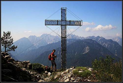
Where the road exits the tunnel and continues over a bridge, you cross the road fence and hit a well seen military path, carved into a rocky wall above the Bombasso creek. Already in the first ravine the protection chains are ruined, so you need to cross it carefully. Into the next ravine, you descend steeply on a soft sand, holding for your convenience a good root of a pine bush. But then the troubles are over and a nice and mostly broad military path takes you in several turns up the slope. Even if the slope is very steep, the path uses nice grassy ledges and gains altitude ascending comfortably. In an hour, the steep slopes are below you and the path enters a dense forrest. There it branches, the marked branch going left. Soon you reach a small graveyard from the World War I, six soldiers of Austro-Hungarian army are burried there. Immediately above, there's a crossing of marked paths. From the right a marked path comes from Pontebba town. That is the longer approach on Monte Brizzia. It is worth going a few minutes down by it, only to see the abandoned alpine meadow, called Stavoli Scalzer, 1241 m. The forrested hill above it was once also heavilly fortified. To ascend Monte Brizzia from the crossroad, you however continue left. The path is now numbered 501 and is called Sentiero Beppi della Schiava. It continues later by the whole ridge on Passo Pramollo. We continue ascending through a steep forrest, but the path is mostly broad and comfortable. Just before the saddle in the main ridge we reach the remains of the upper station of material cable-car from the WW1. Today only a concrete block can be seen. Just above it, we find ourselves on the saddle, 1421 m. The ascent on the panoramic Monte Brizzia now goes southwards. The first part overcomes a steep section through a forrest, then we continue comfortable to the highest point, beyond which we descend again a few more meters to the big cross on the most panoramic edge of the mountain. 2 h from the valley. By the cross there are solar cells, indicating that the cross is lit over night.

Monte Bruca from the south
To continue the tour, we first return on the saddle 1421 m. From there the military path, once called Krasel Weg, continues by the main ridge towards the north. It crosses the bump 1498 m and descends on the next saddle. There it starts crossing the eastern slopes of Monte Bruca (the three-headed summit). If you want to ascend Monte Bruca, continue by the main ridge. The path is tiny, not marked, but clear. It goes by the ridge, you are however soon starting to fight with dense pine bushes. Follow the "path" through best passages, until reaching the steep summit slope. There you need to scramble up carefully. It is best to use pine bushes, because the rock is lose (Schlern formation) and exposure already considerable. So, you fight through the dense greenery on a panoramic summit. But unfortunally there you realize that it is not the main one. Continuation is nowhere described, but the next bump is clearly a few meters higher. I admit I didn't continue, but the terrain is very similar. The second summit may be even easier, but the greenery may be more dense. And close behind it there's also the third one. Not on the map, nor in literature it is said which one is the highest. You return down by the route of ascent.

Crossing below Monte Bruca
From the saddle below the southernmost summit of Monte Bruca, the marked path No. 501 crosses the eastern slopes of Monte Bruca. At first it's easy, but already in the first ravine the path and protection devices are demolished. You carefully climb across and continue around the next edge. There you already see the big scree slopes of Monte Bruca, falling down into Vallone degli Uccelli. That is some broad field of gravel. The upper parts of the face are steep and rugged, so our path needs first to descend considerably. It goes in turns, but on many places it's ruined. You use pine bushes to hold, in ravines there are chains, again in some places broken, but there are no real troubles. You can say that the passages are more unpleasant and tedious, than dangerous and hard. Finally the path reaches its lower point (some good 1300 m) - there once the path from Vallone degli Ucceli came. Today it is closed, because in the canyon it is completely destroyed. Our path No. 501 now enters a nice forrest and starts lightly to ascend towards Sella di Barizze, 1430 m. In the woods you first reach the crossroads where the path No. 523 deters right (towards Monte Cit). You keep left, soon reaching the end of the road and after two turns of it the important saddle. From the saddle (in the forrest) you would have by the road good 1 h 30 min to Passo Pramollo. But the shortest way to descend into the valley of Rio Bombasso is an ex shepherds path, descending directly from the saddle towards the west. You can well see the tiny path in the beginning, later it is lost on many places. But in the upper part if you are careful enough, you will see a few red spots and also many valuable ciarns. You go directly down, later by the distinct ridge below the two water streams. Allways follow the ciarns! Below you will hit an ex cart-road, but if you follow it, you will come to the part where it collapsed into the creek bed. Go left and you will find your way down to the main, asphalt road. Also if you would be going up, the start of this path from the main road is well marked (red arrows), only you need to cross first Rio Bombasso. To the trailhead where your car is parked, you have now a bit more than 1 km of the road.