
-
 10827 Hits
-
 90.48% Score
-
 32 Votes
|
|
Mountain/Rock |
|---|---|
|
|
46.53209°N / 13.36380°E |
|
|
Mountaineering, Scrambling |
|
|
Spring, Summer, Fall |
|
|
6558 ft / 1999 m |
|
|
Overview
Summits, described here
> Monte Scinauz, 1999 m,
> Monte Ghisniz / Gozdec, 1931 m,
> Point 1892 m,
> Monte Cerchio, 1802 m,
> Monte Torre, 1742 m,
> Monte Bruca, 1619 m,
> Monte Brizzia, 1570 m,
> Monte Cit, 1415 m.
General
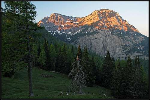
It is hard to believe that in the centre of Europe there's a big mountain which almost nobody climbs. And it is. Rising directly above the main valley of Val Canale / Kanalska dolina, showing his almost 1500 m high south wall to thousands of tourists who drive by on the highway, Monte Scinauz is still being extremely rarely ascended. The reason is not the difficulty of ascent, even if the mountain is by no means easy, but the fact, that until some time around 2000 NATO had a radar operating there, so the ascent was administratively forbidden. After the fall of Iron Curtain the radar was removed, but the paths which once were used, were already almost completely lost. So, still today, you can bet not to meet there anybody. And, if something would happen during the climb, you would be in a very remote area.
So why one would strive to ascend Monte Scinauz? First of all, because it is so very special. You will be one of those rare who, after a real adventure, every year stand on top of it. The ascent is an adventure, except the ruined summit the nature is wild and very beautiful, and, finally, the view from the summit is very broad and the nice surrounding mountains are seen from a new perspective.
|
Three
pictures of Monte Scinauz |
 From the E From the E |
 From the W-NW From the W-NW |
 Southern walls of Monte Scinauz Southern walls of Monte Scinauz |
Radar
 Solar cells
 Military installations
NATO started to build the base on the very top of Monte Scinauz soon after the World War II. They say that it was this radar who first detected Soviet air forces attacking Czech Republic in 1968. Until the end of 80es the base was operating, later one could find the news that the cable car from Val Canale was abandoned and today it is of course completely removed. On the web you can not find information that the access is today allowed, and when reaching on top, you still need to cross a fence with the prohibition inscription. But then you will find nobody on top.
Summit Panorama
 Towards the W-NW
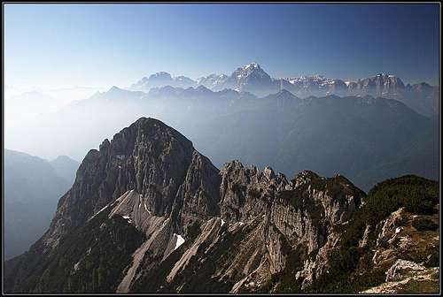 Western Julian Alps from Monte Scinauz
In a nice day you will have an astonishing view all around. The most impressive is the group of Viš and Montaž. Eastern Julian Alps are already quite distant. Towards the SW very charming is the sharp peak of Zuc dal Boor and the neighbouring Monte Chiavals with Crete di Gleris. High mountains are rising also on the western horizon - those around Nassfeld/Passo Pramollo/Mokrine: Monte Cavallo/Rosskofel and Gartnerkofel/Krniške skale are clearly seen. Towards the north the view is completely opened, the next high mountains are the glaciated Hohe Tauern. And along the rest of Carnic Alps towards the east you will distinguish the rounded mountains which finish this long streak.
 Towards the N Towards the N |
 Down on Pontebba Down on Pontebba |
Geography
|
As said, Monte Scinauz is showing its south walls directly above the main valley of Val Canale / Kanalska dolina. That's simple. But the structure of the other sides is very complicated. As the south walls are hard to climb, this results in the fact that all ascents on top are very long and complicated. If any mountain resembles a castle, then it's Monte Scinauz. On all sides, north-east, west and east, there are wild side summits, guarding the final ascent. Long ridges are encircling the three sides of the mountain, forcing mountaineers to cross them if they want on top. And between those ridges there are deep valleys, more gorges, which prevent an easy ascent by forcing you to descend some 200 meters or more, from any side you approach the mountain. It all looks like a perfect defence system. For a first impression, have a look on the embedded sketch. Southeast of the main summit, the summit of Monte Ghisniz, 1927 m, is rising. It is wild and hardly accessible from all sides, but one hunters path still reaches it (climbing passages of UIAA II degree, deteriorated protection devices). But the connection ridge to the main summit is very sharp, consisting of several towers, so the direct summit ascent from Monte Ghisniz would require harder climbing, that is why the tiny path goes by the southern side and only later across the ridge. North-east of the main summit there is a sharp notch, beyond which the Point 1892 m, stands. The passage from it, over the notch on the main summit would also require harder climbing. On the western side, the summit ridge lowers smoothly - first to the Point 1990 m, but then the rugged western face falls deeply down, and before finally lowering into the Uccelli gorge it is additionally guarded by Monte Torre, 1742 m. No reasonable ascent goes over that face on top. |
The northern face is not so very steep, there the normal ascent goes on top. But the 350 m high face ends in the wild Upper Uccelli gorge, so here the story about the two deep Monte Scinauz gorges must be told:
From the western side, the whole narrow massif of Monte Scinauz is encircled by the wild Uccelli gorge (Vallone degli Uccelli). In the lower part there is even a protected path through it, but later it exits and the gorge starts turning towards the north-eastern direction, and then around a corner in the east-southeastern direction, encircling almost the whole narrow massif of Monte Scinauz. The gorge ends on the notch between the above mentioned Point 1892 and Monte Scinauz. This is the first "defence trench".
The second valley or gorge encircles the narrow massif of Monte Scinauz from the east. Near Santa Caterina there is the mouth of Rio Bianco / Beli potok valley, which, cut deeply into the massif, goes far towards the north. After several kilometers it starts slowly turning towards the NW and W, so going far around the massif. This is the second "defence trench", partially encircling the first one, forming a swirl-like mountain structure. So, if you want to reach the base of the northern face, you need to descend once or even twice into these two gorges.
From the main ridge of Carnic Alps, particularly from the summit of Monte Corona / Kronalpe, 1832 m, a long ridge swirls towards Monte Scinauz. It is first harmless and rounded, covered by nice alpine meadows and woods, but after the Biffil alpine meadow it rises to the Point 1892, from which we saw there is no passage on Monte Scinauz. By this ridge the easiest approach to the north face goes, but it is long, and in the final part it again descends into the Uccelli gorge.
 Campanile Alto del Cerchio
 Monte Cerchio / Zirkelspitze
On Monte Corona / Kronalpe, 1832 m, two not very distinct ridges go down towards the south and south-east. The first one lowers on Sella di Barizze, 1475 m, from which a strong ridge goes further southwards on Monte Bruca, 1583 m, and Monte Brizzia, 1540 m. Both are panoramic and can be reached by a hike or scramble. Actually, Monte Bruca consists of 4 summits, where the northernmost one is a quite hardly reachable tower.
Towards the SE across a distinct notch a sharp summit of Monte Cerchio / Zirkelspitze, 1802 m, rises. It was first climbed on November 1st, 1911 by K. Domenigg, H. Rausch and L. Wodicka by the NW ridge. The original UIAA I ascent is today much more difficult (also very crumbly) due to a rockfall. The today easiest ascent crosses the W side and is very overgrown and orientation-wise complicated (also UIAA I). Otherwise in the walls there are also a few more routes. SW of the Monte Cerchio there's also a picturesque tower of Campanile Alto del Cerchio, cca 1500 m. It was first climbed on September 27th, 1931, by the south wall (G. De Lorenzi, D. Roiatti) - UIAA IV degree. Other ridges and valleys are more remote from Monte Scinauz and as they are forming the much broader and less interesting area, they will not be mentioned here. The whole area is still very remote, abandoned and due to lower altitudes heavilly overgrown.
Geology of the area
The whole Carnic Alps chain is built of old paleozoic rocks, but on some areas Triassic sediments were later deposited over those rocks. The whole broad Monte Scinauz area is such an exception. The upper parts of all mountains described here is built of up to 240 million years old Middle Triassic rocks, named Schlern Dolomite. By its nature, it's everywhere in Southern Alps very brittle, so we can understand why our mountains aro so rugged, with ravines full of debris and with trails on so many places ruined of landslides. The mioddle part of Rio Bianco and the area east of it is made of even a bit younger conglomerates and sandstones.
Getting There
As said, all approaches are long and complicated, so also the trailheads are quite remote from the summit of Monte Scinauz.
1. Nassfeld / Passo Pramollo / Mokrine, 1530 m. This is the first choice and the trailhead of the easiest approach. Over the saddle the main road from Hermagor / Šmohor to Pontebba/Pontafel/Tablja goes. From the saddle towards the east a mountain road goes (some 5 km), but it is closed for public traffic.
2. Santa Caterina, 660 m. This village lies in Val Canale / Kanalska dolina and can be reached by the regional road or from the Tarvisio-Udine highway (exit: Pontebba). Near Santa Caterina there is the entry into Rio Bianco / Beli potok valley which is protected as a natural reserve, but there also the hunters path on Monte Ghisniz starts.
3. Egger Alm, 1400 m. This broad alpine meadow lies on the northern, Austrian side of the main Carnic Alps ridge and can be reached from Hermagor / Šmohor by a good road. From Egger Alm a mountain road goes on Kersnitzen Sattel / Sella Chersnizze and further on Moederndorfer Sattel / Sella Zille, 1497 m, but it is closed for public traffic. And that is more or less all. The mouth of Uccelli gorge can not be recommended as the ascent through it would be too long. Also the trailheads more east to the Rio Bianco / Beli potok are too remote.
Routes Overview
On Monte Scinauz itself
 The upper Uccelli gorge
 Exposed hunters path
1. From Nassfeld / Passo Pramollo / Mokrine. First a long but easy hike (Traversata Carnica) to Malga Biffil (alpine meadow), 4 h, road almost till there (2019). Then a demanding crossing (hunters path) into the upper part of Uccelli gorge (1 h) and over the northern face on top (1 h 30 min). Altogether 6 h, a demanding, poorly marked hunters path (exposed), easy climbing passages of UIAA degree I.
2. Through Rio Bianco valley. This valley/gorge was once (60 years ago) marked, but after the summit of Monte Schinauz was closed, the path was probably not maintained. Today, the valley is a natural reserve and the passage through the lower part is allowed only if accompanied by an authorised person. From the middle part of Rio Bianco valley to Malga Biffil, the Traversata Carnica ascends (400 m) up on the mountain meadow. But in 2010 there were warning inscriptions that the part of the path between Malga Biffill and Rio Bianco is devastated and not passable without securing. Also from Sella Clinach, 1441 m, down to Rio Bianco the marked path requires some skills. From Malga Biffil on top you would then continue as described above under #1. The whole ascent would take some 6-7 hours, and would mean a 1900+ m ascent.
3. From Egger Alm. From the parking place you would continue on Moederndorfer Sattel / Sella Zille, 1497 m, then descend 200 m into the upper Rio Bianco valley, continue a bit down by it and then ascend Malga Biffil - either by a more direct (not marked) path (years ago it was also devastated by a landslide), or by Traversata Carnica (in 2010 closed - see above #2). From Malga Biffil on top as described above under #1. The whole ascent would require some 5 h, its difficulty would depend on conditions of the two ascents up from Rio Bianco - and the difficulty of the final ascent is as described above.
4. By the hunters path from Santa Caterina. The path is described by recent visitors as demanding, in some sections requiring climbing up to UIAA II degree, mentioning also that a few securing devices on the hardest passage are quite ruined. After reaching below the fore-summit of Monte Ghisniz / Gozdec (it can be also reached in easy climb of up to UIAA II degree), it is described to cross by the southern side towards the west. The tiny path, still weakly marked by red dots goes by the southern side of the connection ridge, all the times crossing the steep slopes. It is a hard and exposed scramble, finally bringing you on a notch in the ridge. There you cross the ridge and descend (protection devices) a bit on the NE side of the crest, after which you resume the connection crest and reach first the cable-car station and a few minutes later the main summit. Only for experienced, belaying recommended. This would be the quickest ascent, but still some 4 h 30 min would be required.
5. By the SW and later NW ridge. This is a possible, but must be also a completely crazy route, taking some 7 h 30 min from San Leopoldo / Lipalja vas. It requires easy climbing over a few passages (up to degree UIAA II), but what makes it unpleasant is rough, densely overgrown terrain and quite some ups and downs and slopes crossings. The route continues from the marked route on Monte Cit, then to Monte cit di Dentro, then it ascends Torre, 1742 m, descends from it and then crosses the whole western slope to the NW ridge, by which it gains the top.
Other paths and climbs
Monte Cit, 1416 m. South-west of Monte Scinauz, still in its narrow massif, there is a less important summit above the main valley, which can be ascended by a marked path. It offers a visit to a scenic mountain landscape and some nice views. From San Leopoldo, 602 m, in the main Val Canale valley you follow the marked path towards the north. It follows a forrested rib and finally ascends Monte Cit from the eastern side. There, you will find already the fortifications from the World War I. This summit was, together with the two on the other side of Uccelli gorge in hands of Austro-Hungarian army. The marked path goes from Monte Cit further northwards. After a dangerous, completely eroded passage, there the Monte Cit di Dentro, 1555 m, rises and from it the marked (ex military) path continues northwards, descending into the middle Uccelli gorge. This part is also demanding, requiring a lot of care. After crossing the Uccelli creek, the path ascends again (some 400 m), finally reaching Sella di Barizze, 1430 m, the important saddle, delimiting Kronalpe on the north, from the chain of Monte Bruca, 1583 m, and Monte Brizzia, 1540 m, on the south. The ascent on Monte Cit would require 2 h 30 min, the whole crossing good 5 h.
 Monte Bruca and Monte Brizzia from the NW
Monte Bruca, 1619 m, and Monte Brizzia, 1540 m. These two summits are rising even west of Vallone degli Uccelli, but still in the broader group of Monte Scinauz. They were once heavilly fortified by the Austro-Hungarian army, today they are a fine goal of a mountain hike. Two marked paths go on the saddle between the two summits, The longer comes just from Pontebba / Pontafel / Tablja, 561 m, the shorter comes from the west, from the main road through Rio Bombasso. After reaching the saddle, you go south and north on both summits. Monte Brizzia is easily reached by a marked path, while Monte Bruca ascent is not marked. The southernmost summit, 1583 m, can be reached by scrambling, bushwacking and easy climbing up to UIAA I degree. The next two summits (1610 m and 1619 m) are even a bit more difficult, but normal ascents don't exceed UIAA I degree. The northernmost tower, 1614 m, is more difficult. The normal ascent goes by the ridge from Sella di Barizze (so, from the north), when the ridge becomes more difficult, the route turns left and crosses to the E ridge and by it on the summit. Difficulty altogether is UIAA I-II. Across the eastern slopes of Monte Bruca a demanding (also quite deteriorated) marked path crosses towards Sella di Barizze, 1430 m, thus enabling also a round tour.
Huts and Camping
 Malga Biffil
 Malga Biffil
There is no official mountain hut in the whole area. On Biffil alpine meadow there is a ruined shepherds hut which has one room preserved and permanently opened so you can spend a night in there. On all alpine meadows there are also forrest and hunter huts - in good condition but closed. If a one day tour is too much for you, the most recommended option is to overnight in a tent on Biffil alpine meadow. Till June it's abandoned and you will be alone there. Take enough water with you.
 |
 |
 |
Red Tape
The whole area is very remote and there are no restrictions. As said the mountain road from Nassfeld / Passo Pramollo / Mokrine is closed for public traffic. Also the access prohibition into the Natural reserve of Rio Bianco / Beli potok (at least the lowel part of the valley) was already mentioned.
When to Climb?
Depending on the amount of snow the north face is most easilly passable from June and till late in autumn (October). For a one day tour you will need a long day, so better come earlier. Spring (June) and autumn are of course the most beautiful seasons on those meadows, but in June there's still a big chance of snow rests on the norhern face.
Sources

- Martin Fürnkranz: Sinouz (Monte Scinauz), der geheime Berg. Oesterreichischer Alpenverein, Bulletin No. 54, Summer 2003. http://www.oeav-obergailtal.at/PDF/Sektionszeitungen/Sommer2003.pdf
- Martin Fürnkranz: Sinouz (Monte Scinauz), der geheime Berg (updated web blog with excellent pictures).
- Guidebook and photomonography (in Slovenian): V. Pogačnik: Kar na Karnijce. Založba Narava, 2011.
- R. Gaberscik: Guida escursionistica alle Alpi Carniche. Studio64srl Edizioni, 2010 (7th edition), Genova. In Italian.