
-
 3792 Hits
-
 77.48% Score
-
 8 Votes
|
|
Route |
|---|---|
|
|
46.53209°N / 13.36380°E |
|
|
Scrambling |
|
|
Spring, Summer, Fall |
|
|
A long day |
|
|
UIAA I, exposed scrambling |
|
|
Rating the Route (By Hiking Standards)
The grading system for hiking and scrambling routes is here.
0. General: From 1530 m to 1999 m, but many ups and downs and also some 10 km of distance. Exposition N and W. At first an easy hike up and down across several alpine meadows. A road and good paths, mostly marked. A few orientation challenges. After Malga Biffil (alpine meadow) a hard and exposed hunters path. Difficult orientation. Over the north face an easy scramble, partially a tiny path, marked with rare red dots. A few passages of easy climbing up to UIAA degree I. All the time you need to care about orientation. Gear: Good hiking shoes and poles. If the northern slopes contain snow fields (till June), ice pick and crampons are useful. Later in summer not needed. The tour can not be shortened, the whole area is lonesome and remote. By the Swiss (SAC) Hiking Scale the rating would be T5.
1. Effort: cca 1000 m by the shortest variant, otherwise 200 m more. Also on the return some 500 m of ascent. 6 h for ascent, 5 h for return.
2. Power: 3 - Medium hard (easy climbing).
3. Psyche: 4 - Hard. Several exposed passages without any good holds or other protection.
4. Orientation: 4 - Hard. Even if the route is marked by rare red dots, it constantly requires attention, good orientation skills and choosing best passages.
Overview
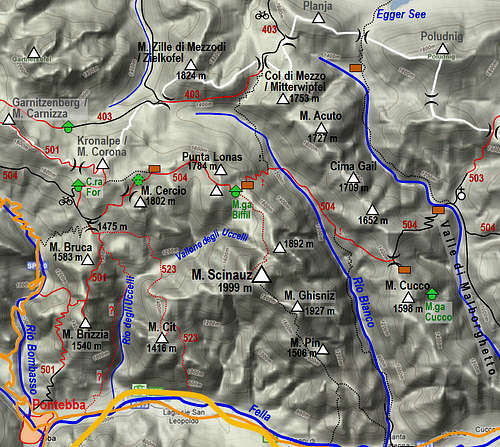
As described on the main page, all ascents on Monte Scinauz are long and somewhat complicated. The northern ascent is considered to be normal. It means a small adventure, where you mostly rely on yourself and your team. The scenery is wild and very beautiful, for an experienced hiker the tour is highly rewarding. The key to the final ascent is Malga Biffil (alpine meadow), which can be reached from several sides. But all approaches are long and in recent years some of them also destroyed by landslides. The approaches from the north (Austria - Egger Alm) and from the East (across Rio Bianco) are mentioned (but not described in detail) on the main page. As these paths are in bad condition, consider taking a rope with you. Here the approach from Nassfeld / Passo Pramollo / Mokrine, 1530 m, to Malga Biffil will be described. It is easy, but the duration will depend on the option you choose. Several ideas will be presented, so you can plan either a quick one day ascent or a scenic one and half day hike on Monte Scinauz. See the parent page how to get on Nassfeld / Passo Pramollo / Mokrine road pass!
Getting to Malga Biffil
Gaining almost no altitude, but doing some 8 km of distance does not look very attractive. But it is almost a must. From other sides Malga Biffil is harder to reach. So, from Nassfeld / Passo Pramollo / Mokrine, a mountain road goes now (2019) almost till Malga Biffil.
Idea 1. The mountain road which goes from Nassfeld / Passo Pramollo / Mokrine towards the meadows on the, east first makes you think to use a bike. You will be a bit quicker, but the road is still going up and down unpleasantly. Also consider not to use the whole road, but only to Casera For (4 km), because after that meadow it descends 100 more meters and later crosses another saddle.
Idea 2. If you plan to sleep on Malga Biffil (recommended) then consider going there by the whole panoramic ridge and take the summits: Auernig, Garnitzenberg / Monte Carnizza and Monte Corona / Kronalpe. There is quite some up and down, but the tour is very rewarding. It will be described elsewhere.

Casera For
So normally you will start walking by the mountain road which begins just opposite by the lake on Nassfeld / Passo Pramollo / Mokrine. In a 15 minutes ascent you will reach the panoramic Malga Auernig, cca 1600 m. Continue by the road eastwards. Soon you will see the inscriptions for the marked path, deterring left up on the ridge. But continue by the road all the way to the crossroads below Casera For (45 more minutes). There you have two options: 1. Continue by the road, following marks of the trail No. 504. The road descends towards the SE. After 10 minutes a side road deters left and by it the trail No 504 goes. Follow it towards the E and later towards the NE, ascending over scree slopes on the saddle north of Monte Cerchio (1697 m). From the lowest part you did 200 m of ascent. From the saddle the road descends again some 60 meters on the abandoned Malga Cerchio and crosses it in the NE direction. Finally you reach the upper Malga Cerchio (hut and water source), 1700 m, where variants 1 and 2 join. 1 h 15 min till here. 2. Shepherds shortcut. Much shorter is the direct connection between Casera For and the upper Malga Cerchio. But it is not marked all the time. From the crossroads you take the road up to Casera For (5 min) and continue by the path No. 501 towards below the summit of Monte Corona / Kronalpe. You do some 150 meters of ascent. There you must find the path towards the right. The branching is not seen well, looks almost hidden. But also if you continue towards the summit of Monte Corona / Kronalpe, you can not miss much. Go anywhere by broad meadow right - the moutain hut on Malga Cerchio is seen well. If you hit the shepherds path, it will take you eastwards around the corner and then by nice meadows down on the upper Malga Cerchio. The path is broad and can later not be missed. 1 h till here.

Malga Cerchio

Monte Scinauz from Malga Biffil
From the upper Malga Cerchio the path follows the main ridge (on its southern slopes) which swirls towards Monte Scinauz. It is broad and well marked. First you ascend a little, then go horizontally, change direction a bit towards the SE and ascend again on the saddle between Punta Lonas, 1784 m, and the forrested dome south of it. From there descend 100 meters in the eastern direction on Malga Biffil. First you will reach the shepherds hut (the stall is only a ruine), the forrest/hunters hut is around the corner, some 50 m further. If you have a tent it is a good idea to continue along the meadow towards the SE and find the path where next day you will start the summit ascent. Do not go in the woods immediately below the two huts, even if a path goes there. Continue horizontally some 10 minutes, mostly by the lower edge of the meadow, finally reaching a small pond on the meadow ridge. There close-by, some 50 meters further, search for the marks on the path. You had already passed one dead larch tree before, by the second one the path goes in the woods.
Malga Biffil - Monte Scinauz

The upper Uccelli gorge

Hunters path into the upper Uccelli gorge
So, from below the pond in the SE part of Malga Biffil you enter horizontally the forrest on the right. The path is marked occasionally by red spots and also some blue marks. You need to be careful not to lose it. There are others, weaker, so allways search for the next spot. The path first crosses an unpleasant ravine which requires all care. The second ravine is a small one and down on the other side you see the path being resumed. But there you will find no marks. A few careful steps over rocks are needed, without good grips for hands. On the other side you need to ascend some good 15 meters and find marks again. Obviously in the past the path crossed the ravine higher. Then you continue horizontally to the third ravine, which again requires care. Again you keep the altitude and finally find yourselves above the upper Uccelli gorge. A tiny exposed path crosses the slopes in descent into it. On several places you might have only a pine bush root to hold and a lot of care is needed again. 1 h from Malga Biffil till here.

Over the north face
From the upper Uccelli gorge the path continues horizontally across the northern slopes of Monte Scinauz. You even lose some altitude, a passage or two are again tricky. Then finally the path starts winding up through pine bushes and over an open terrain. You mostly follow marks, only on one place (dead branch, marked red) you continue directly upwards (ciarn) and resume the path higher. So you reach a broad open terrain in the middle of the face where marks are lost. You see natural passages on the right - you simply go up by the rightmost scree ravine until it gets rocky. There you see marks again. Higher they exit right in dwarf pines, but you can scramble through the ravine too. Above, you are already below the rocky walls and the path starts crossing quite towards the left. Finally in a rocky ravine you need to climb over a rocky edge (UIAA I), on the other side marks lead you directly up. There the slope is rocky and steep, so some easy climbing is needed. Above, you already reach the final rocky barrier. You overcome it in an easy climb on the right side, above reach pine bushes and through a true tunnel gain the summit ridge. There turn left and in some 10 minutes through pine bushes you are by the ex military installations. On the top there is a huge flat plateau.
You best descend by the same route.