
-
 8274 Hits
-
 86.37% Score
-
 22 Votes
|
|
Mountain/Rock |
|---|---|
|
|
37.87350°N / 13.96500°E |
|
|
Hiking, Scrambling, Canyoneering |
|
|
Spring, Summer, Fall, Winter |
|
|
5886 ft / 1794 m |
|
|
Overview
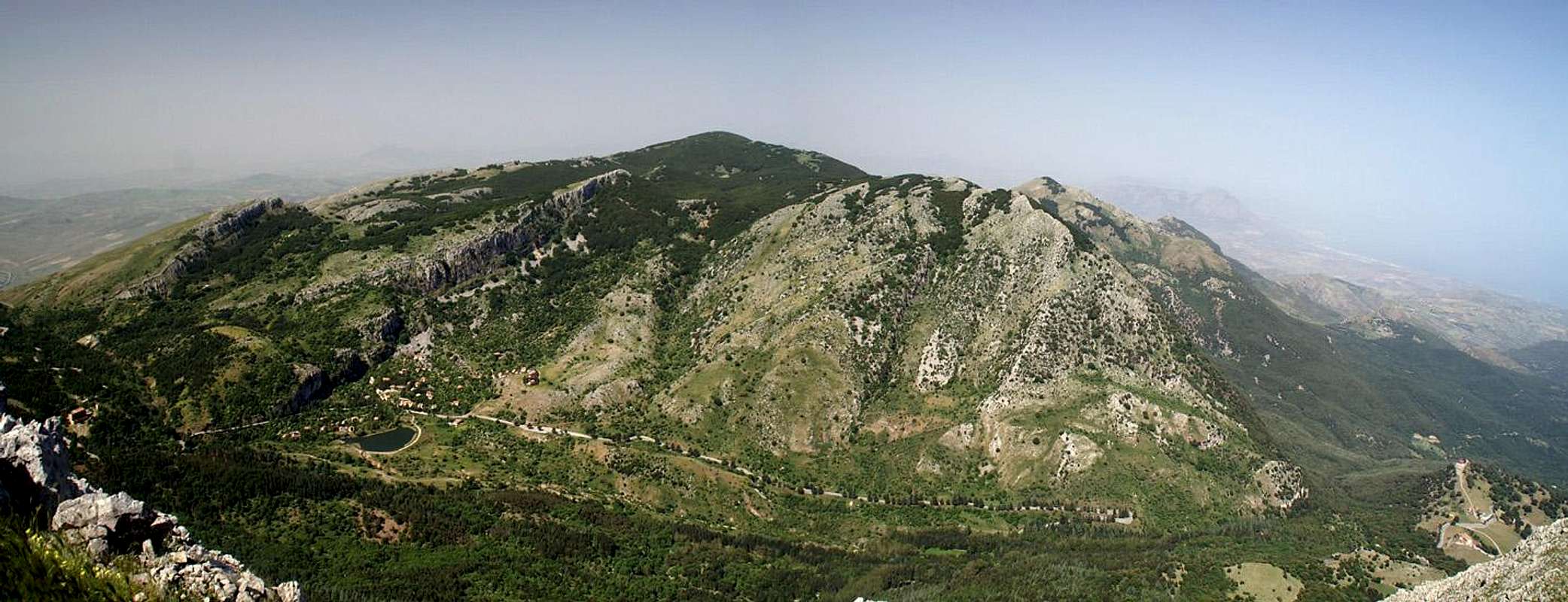
 Monte dei Cervi from Monte San Salvatore Monte dei Cervi from Monte San Salvatore |
Like all the higher mountains of the Madonie mountain range on Sicily, the summit of Monte dei Cervi is a large plateau while its sides are considerably steep, especially to its western side. The mountain - or rather the Cervi Group as there are several important side summits - is located to the west of Le Madonie, rising directly out of the Himera Valley 1700m below. It is made up of limestione rock and you can imagine from the comment about the summit plateau that this limestone is broken and karst-like with many towers, caves, canyons - in short: all kind of possible erosion forms.
What distinguishes Monte dei Cervi from its neighbours are the canyons - especially the ones on its southern slope. To the south-east you find Vallone Inferno, the Valley of Hell, which you will find a suitable name after you have scrambled though it. Enclosed by steep vertical walls the valley climbs steeply up the Monte dei Cervi slopes with scree of any size underfoot and macchia brambles of all stinging and scatrching kinds to walk through. The other "canyon" is La Padella, a pan-shaped depression where the underground caves gave way to form a neat circular collapse zone, through which a deep canyon-like gully leads. Needless to say that La Padella is every bit as hellish as Vallone Inferno to get through. What adds to the Cervi adventure is the fact that the slopes just beneath the summit plateau are overgrown by a dense labyrinth-like forest of dwarf beeches. You can get lost easily.
Though the group is used for cattle grazing it is a very lonesome area. You will have trouble meeting anyone, once you have left the forestry station at the trailhead behind. The going is rough and often footing is not secure even unstable. Moreover, plants overgrowing the rocks make footing even more slippery so that you have to be extra careful not to slip and fall (believe me, I know what I'm talking about).
The Cervi Group and Le Madonie
  |
As mentioned above Monte dei Cervi is the highest summit of the westernmost subgroup of the Madonie mountain range. Apart from Monte dei Cervi, the more importants summits are Cozzo Vituro (1507m) to the south, Cozzo Piombino (1620m) to the east, Pizzo Colla (1670m), Cozzo Morio (1611m) and Pizzo Antenna (1697m) all to the north-east. The group is separated by Portella Colla from the highest and largest group of the Madonie, the Carbonara Group to its east.
Getting There
 The Mufara Group seen from La Padella
Sicily can be reached from all Italian and the major European airports by plane. There are two large international airports, one at Catania in the east and one at Palermo. Since Palermo is much closer to the mountain than Catania my itinerary starts here. Also, Palermo is the main ferry port in the area.
From Palermo airport
- Take motorway A29 direction Palermo
- In Palermo the motorway turns into a four laned city highway which circles the city to its south
- The city highway turns into motorway A19 direction Catania
- Turn off at the exit Scilatto and take SP613 southeast to Polizzi Generosa
- In Polizzi Generosa turn left (north) onto SP119 to Cefalù
- After you have negotiated a deep valley the road climbs until you reach the exit to a forrestry station to the left. Take the dirt road and park near the entrance gate to the station.
Red Tape
 Orchis Neotinea tridentata
Monte dei Cervi and its group belong to the Parco delle Madonie, which was established in 1989 and covers an area of approximately 40000ha. In the Sicilian parks you can climb and hike almost everywhere. Obstacles are the many barbed wire fences, which however can be crossed. They serve only for the pastures and to keep cattle sheep and horses from getting lost in the vast terrain.
Camping is not tolerated in the park, better look for accommodation in the nearby towns and villages (Polizzi Generosa). The northern coast of Sicily is close by and there you will be able to find all kinds of accommodation (see below).
Accommodation
You can quite easily find hotel rooms and apartments everywhere on the coasts. All European travel companies offer accommodation so a visit to your nearest travel office will find you some. In the mountains themselves accommodation is much harder to come by. Since camping is not allowed (see red tape) you have to ask at the local inns. Moreover there are some farms which offer “agriturismo” though on Sicily this often means only food and no rooms.Weather Conditions
Sicily is located very close to northern Africa (Marsala on the west coast is closer to Tunis than to any place on the Italian mainland), thus temperatures can get very high. March, April and early May are the best months if you plan to hike the mountains, the winter can be wet, the summer scorchingly hot. Here the nearest weatherunderground link for Palermo:Maps & Books
Maps
Unfortunately there are no current topographic maps of Sicily. The best are reported to be more than 50 years old and probably are the same as the basis for the digital maps of atlanteitaliano.it.
As a workaround you can use street maps for general orientation together with a good guidebook (see below). The most accurate maps are scaled 1:200000, sometimes detailing everything down to forest and dirt roads through the mountains. I settled for
- Sizilien
Shell Generalkarte
1:200000
Mairs Geographischer Verlag
ISBN: 3-8297-2080-7
Books
Since there are no good topographical maps of Sicily you should take care to get a good guidebook. The one I used is in general excellent. For Monte dei Cervi the route descriptions were accurate - however, if you think of doing the Vallone Inferno route, you must pay attention at the exit of the valley. Right before you would have to climb a cattle fence turn left onto a wide ridge which leads to the summit. The book is available in German and English.
- Sizilien / Sicily
M. Omidvar
Rother Verlag
ISBN:
3-7633-4266-4 (German)
3-7633-4813-1 (English)