
-
 5274 Hits
-
 83.1% Score
-
 16 Votes
|
|
Mountain/Rock |
|---|---|
|
|
37.84296°N / 14.12430°E |
|
|
Hiking |
|
|
Spring, Summer, Fall, Winter |
|
|
5446 ft / 1660 m |
|
|
Overview
 Pizzo Catarrinecci as seen from Contrada Trentamazze Pizzo Catarrinecci as seen from Contrada Trentamazze |
After having taken you to the southern and western sides of the Madonie mountain range of Sicilia I think it is time to take a look eastward. There - actually in the south-east of the Group you will find a subgroup of several smaller summits all popping out of a long stretched summit plateau. Pizzo Catarinecci is the highest of these summits and thus the subgroup can be dubbed Catarinecci Group.
The plateau of the Catarinecci Group rises slowly from north to south and culminates in a lovely (there is simply no other word for it) summit meadow, Contrada Trentamazze, complete with a source in the middle and a flock of sheepstanding by for decorative purposes. This meadow is surrounded by the highest summits of the Catarinecci Group, all at very similar elevations, between 1620m and 1660m. To the "outside" the summits drop of into the surrounding valleys and especially the Catarinecci east face is one of the most impressive ones of them all. You can take the tour around and over all of the summits to obtain ever changing views of that little plateau.
Speaking of views: the Catarinecci Plateau is located at a slight distance of roughly 10km from the nearest mountain of the remaining Madonie Subgroups. Thus the view of the range is nearly perfect with Monte San Salvatore, Monte Zuacalla and Pizzo Carbonara, Sicily's second highest mountain up close in the west. To the east a slightly larger distance separates Pizzo Catarinecci from the range of the Monti Nebrodi and to the south you will find the central highlands of Sicily - vast hilly plains which nevertheless are located at an elevation around 700m.
Thanks to its being separated from the Madonie mountain range the Pizzo Catarinecci Group is set apart geologically as well. Its rock - rather than being the usual Sicilian limestone - is quarzite sandstone which in some respects even mimics granite. Only if you touch and scratch it you will be able to tell its composition. It is slightly reddish and home to numerous lizards. As for flora you will find coutless holly bushes on the slopes of Pizzo Catarinecci which all grow in pyrammid - or tent-shaped forms.
|


Contrada Trentamazze
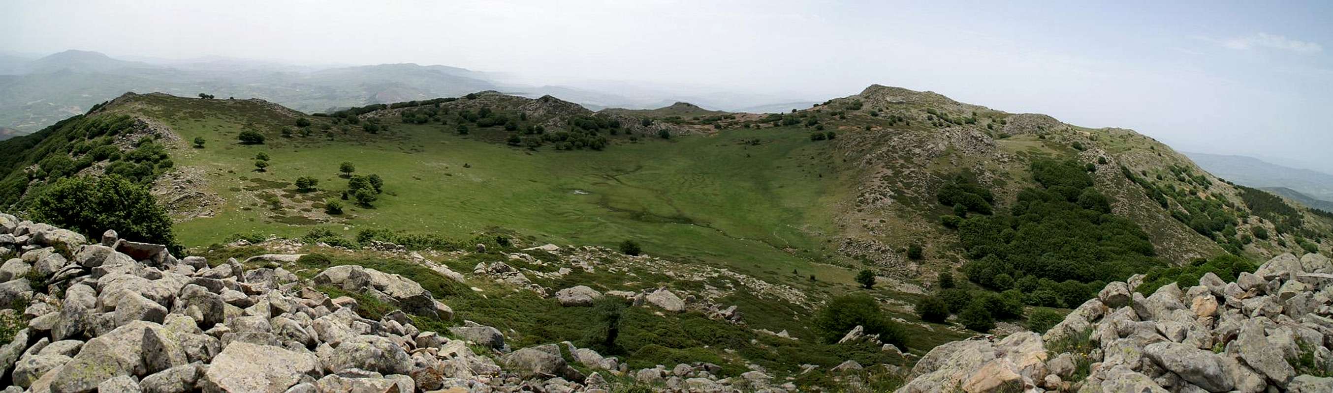  |
As stated above, the summit pasture of the Catarinecci Group is definitely worth the climb. Certainly not of high alpinistic importance it nevertheless is an extreme pleasure to hike across or scramble around. The whole circle won't take you more than an hour but you will see the vicinity under ever changing aspects.
|


Those summit views...
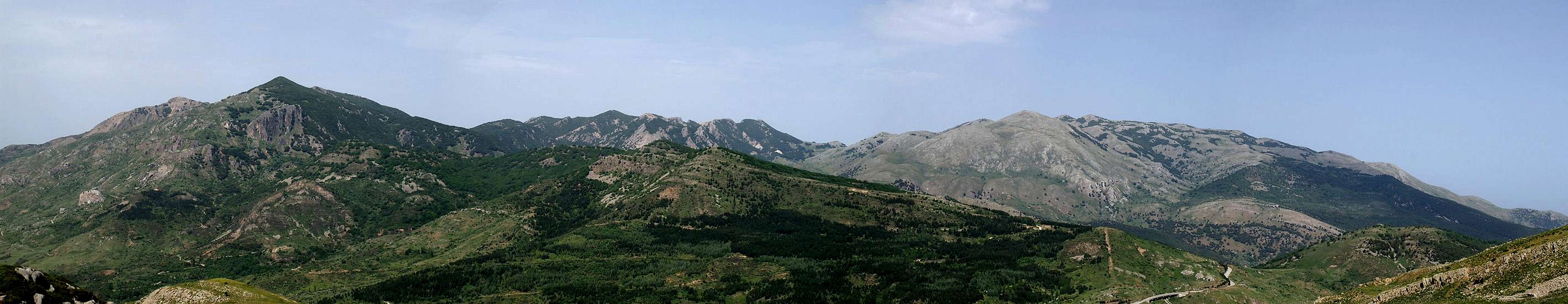 Monte San Salvatore (1913m) is to the left, Pizzo Carbonara (1974m) to the right |
Instead of posting tens of close-up shots of the Madonie let it suffice to have this panorama of the mountain Group. Three of its subgroups can be seen here the San Salvatore Group to the left, The Mufara / Zuacalla Group in the centre (the ridge in the back) and the Carbonara Massif to the right. These are - apart from Monte Etna - Sicily's highest mountains and are up to 1500m higher than the surrounding valleys.
Getting There
Sicily can be reached from all Italian and the major European airports by plane. There are two large international airports, one at Catania in the east and one at Palermo. Since Palermo is much closer to the mountain than Catania my itinerary starts here. Also, Palermo is the main ferry port in the area.From Palermo airport
- Take motorway A29 direction Palermo
- In Palermo the motorway turns into a four laned city highway which circles the city to its south
- The city highway turns into motorway A20 direction Messina
- Turn off at the exit Castelbuono and follow SS286 tthrough Castelbuono to Geraci Siculo
- At the exit of Geraci Siculo - close to the old castle ruins a road turns of to the right. Park your car here at this trailhead.
Red Tape
 Dactylorhiza romana
Pizzo Catarinecci and its group belong to the Parco delle Madonie, which was established in 1989 and covers an area of approximately 40000ha. In the Sicilian parks you can climb and hike almost everywhere. Obstacles are the many barbed wire fences, which however can be crossed. They serve only for the pastures and to keep cattle sheep and horses from getting lost in the vast terrain.
Camping is not tolerated in the park, better look for accommodation in the nearby towns and villages (Polizzi Generosa). The northern coast of Sicily is close by and there you will be able to find all kinds of accommodation (see below).
Accommodation
You can quite easily find hotel rooms and apartments everywhere on the coasts. All European travel companies offer accommodation so a visit to your nearest travel office will find you some. In the mountains themselves accommodation is much harder to come by. Since camping is not allowed (see red tape) you have to ask at the local inns. Moreover there are some farms which offer “agriturismo” though on Sicily this often means only food and no rooms.Weather Conditions
Sicily is located very close to northern Africa (Marsala on the west coast is closer to Tunis than to any place on the Italian mainland), thus temperatures can get very high. March, April and early May are the best months if you plan to hike the mountains, the winter can be wet, the summer scorchingly hot. Here the nearest weatherunderground link for Palermo:Our own experience tells us that on the higher mountains of Sicily you can encounter fierce winds. On Pizzo Catarinecci and Pizzo Carbonara the winds were so strong that they repeatedly knocked us off balance. With unsure footing on some of the rocky parts this can get dangerous - if not for your life but surely for your bones and ligaments.
Maps & Books
Maps
Unfortunately there are no current topographic maps of Sicily. The best are reported to be more than 50 years old and probably are the same as the basis for the digital maps of atlanteitaliano.it.
As a workaround you can use street maps for general orientation together with a good guidebook (see below). The most accurate maps are scaled 1:200000, sometimes detailing everything down to forest and dirt roads through the mountains. I settled for
- Sizilien
Shell Generalkarte
1:200000
Mairs Geographischer Verlag
ISBN: 3-8297-2080-7
Books
Since there are no good topographical maps of Sicily you should take care to get a good guidebook. The one I used is in general excellent. For Pizzo Catarinecci the descriptions were accurate. Some of the route however has changed a bit and it might be advisable to follow the rocky ridgelines than to struggle with the omnipresent Sicilian undergrowth.
The book is available in German and English.
- Sizilien / Sicily
M. Omidvar
Rother Verlag
ISBN:
3-7633-4266-4 (German)
3-7633-4813-1 (English)