
-
 10270 Hits
-
 85.87% Score
-
 21 Votes
|
|
Mountain/Rock |
|---|---|
|
|
37.83921°N / 14.05598°E |
|
|
Hiking, Scrambling |
|
|
Spring, Summer, Fall, Winter |
|
|
6276 ft / 1913 m |
|
|
Overview
 Eastern view from the San Salvatore summit. Monte Etna in the distance Eastern view from the San Salvatore summit. Monte Etna in the distance |
As the third highest mountain of Sicily, second highest of the Madonie mountain range Monte San Salvatore stands out among the Sicilian mountains. Granted, its neighbour, Pizzo Carbonara has several summits which surpass Monte San Salvatore’s elevation but since Pizzo Carbonara’s top is a summit plateau it is safe to regard Monte San Salvatore as the third highest of the island. Moreover the mountain is large enough to be considered one of the subgroups of the Madonie mountain range, together with its satellites.
Monte San Salvatore – like more than 90% of the Madonie Range – is made up of karst-like limestone. It has smooth slopes which are, however, broken by deep valleys in which dolomite like formations can be found. Yet the rock quality being rather poor much of the mountain has been eroded down into rubble. Caves and gullies crisscross the mountain, the former often collapsed, the latter often filled with dwarf firs and beaches. As befits the third highest mountain of any country the views of San Salvatore’s summit reach far, mostly because it is higher than the eternal cloud of Sicilian haze. Thus Monte Etna – more than 100km away - can be seen like it would hover far above the ground.

The Monte San Salvatore subgroup of the Madonie Range is one of the very few places where the nearly extinct Nebrodi Fir (Abies nebrodensis) can be found. The tree is endemic to northern Sicily and actually only occurs in the Madonie range. In 1995 there were less than 30 trees left on Monte Scalone and Monte Cervo. Meanwhile today every single of these trees is protected by a strong fence and there have been efforts to breed them, which is a slow process on the arid ground they stand on. Apart from the trees you will be able to find orchids in abundance, mainly orchis species but also a few ophrys ones.
To the south of Monte San Salvatore you find a lesser summit which goes by the name of the pilgrimage chapel on its top, Madonna dell’Alto. The chapel itself is a popular pilgrimage destination on any of the holidays of the virgin Mary but mostly so on Aug 8th when all the neighbourhood convenes there – on foot, by mule – or by SUV. That day this remote area gets really crowded with picknicks going on all around the chapel and on the southern slopes of Monte San Salvatore. On other days you can be all but sure to have the mountain to yourself as ascent roads and routes are very lengthy. Given the intense Sicilian heat the best time for a visit is early spring.
The San Salvatore Group and Le Madonie
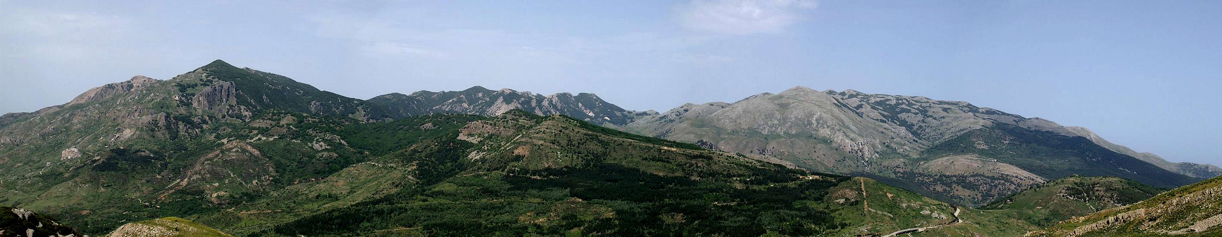  Monte San Salvatore (1913m) is to the left, Pizzo Carbonara (1974m) to the right |
The Monte San Salvatore Group is located to the south of the Madonie mountain range. It consists basically only of the wide summit of Monte San Salvatore together with a number of lesser summits to its side. The most important of these lesser summits is Madonna dell'Alto, on the above pano to the far left. Though it appears smooth sloped from all sides, the slopes can be very rugged with limestone rocks to balance upon and dwarf trees to negotioate through.
Getting There
 Monte Etna
Sicily can be reached from all Italian and the major European airports by plane. There are two large international airports, one at Catania in the east and one at Palermo. Since Palermo is much closer to the mountain than Catania my itinerary starts here. Also, Palermo is the main ferry port in the area.
From Palermo airport
- Take motorway A29 direction Palermo
- In Palermo the motorway turns into a four laned city highway which circles the city to its south
- The city highway turns into motorway A19 direction Catania
- Turn off at the exit Scilatto and take SP613 southeast to Polizzi Generosa
- In Polizzi Generosa turn left (north) onto SP119 to Cefalù
- After you have negotiated a deep valley the road climbs until you reach the exit to a forrestry station. From there go on for 1km until you reach a gate to the right. This is the trailhead.
Red Tape
 Ophrys tenthredinifera
 Monte San Salvatore and its group belong to the Parco delle Madonie, which was established in 1989 and covers an area of approximately 40000ha. In the Sicilian parks you can climb and hike almost everywhere. Obstacles are the many barbed wire fences, which however can be crossed. They serve only for the pastures and to keep cattle sheep and horses from getting lost in the vast terrain.
Camping is not tolerated in the park, better look for accommodation in the nearby towns and villages (Polizzi Generosa). The northern coast of Sicily is close by and there you will be able to find all kinds of accommodation (see below).
Accommodation
You can quite easily find hotel rooms and apartments everywhere on the coasts. All European travel companies offer accommodation so a visit to your nearest travel office will find you some. In the mountains themselves accommodation is much harder to come by. Since camping is not allowed (see red tape) you have to ask at the local inns. Moreover there are some farms which offer “agriturismo” though on Sicily this often means only food and no rooms.Weather Conditions
 Monte dei Cervi (1794m), Monte Zuacella (1869m), Pizzo Carbonara (1979m) |
Sicily is located very close to northern Africa (Marsala on the west coast is closer to Tunis than to any place on the Italian mainland), thus temperatures can get very high. March, April and early May are the best months if you plan to hike the mountains, the winter can be wet, the summer scorchingly hot. Here the nearest weatherunderground link for Palermo:
Maps & Books
Maps
Unfortunately there are no current topographic maps of Sicily. The best are reported to be more than 50 years old and probably are the same as the basis for the digital maps of atlanteitaliano.it.
As a workaround you can use street maps for general orientation together with a good guidebook (see below). The most accurate maps are scaled 1:200000, sometimes detailing everything down to forest and dirt roads through the mountains. I settled for
- Sizilien
Shell Generalkarte
1:200000
Mairs Geographischer Verlag
ISBN: 3-8297-2080-7
Books
Since there are no good topographical maps of Sicily you should take care to get a good guidebook. The one I used is in general excellent. For Monte San Salvatore the route descriptions were accurate - though misleading when it comes to the vegetation barring the way on the descent to Madonna dell'Alto. The book is available in German and English.
- Sizilien / Sicily
M. Omidvar
Rother Verlag
ISBN:
3-7633-4266-4 (German)
3-7633-4813-1 (English)