
|
|
Mountain/Rock |
|---|---|
|
|
22.37695°S / 44.70267°W |
|
|
Itamonte |
|
|
Hiking, Mountaineering |
|
|
Winter |
|
|
8481 ft / 2585 m |
|
|
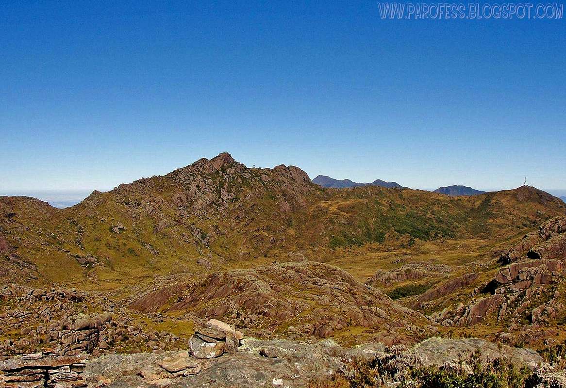
Morro da Antena visible at the far right side of the picture, with an antena at the top.
Great mountains of my country. Both in Itatiaia NP. Nov 2013
As almost nobody goes there, there's no trail, only one road.
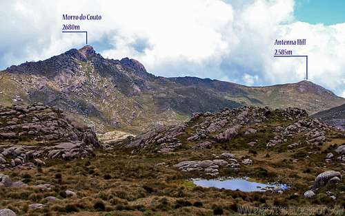
The park itself really is something. It has something around 35 summits, most of them, higher then 2.400 m above sea level. Loads of rock climbing routes, a rock climbing school and training walls at the rocks of Morro do Couto, another big brazilian mountain of 2.680 m.
Getting There
By bus
From Minais Gerais/ São Paulo/ Rio de Janeiro, you have to take a bus to a little city called Itanhandú. Several bus companies can take you there. Once you get to Itanhandú, take a nother bus from the same bus station to Itamonte, a smaller town, at the bottom of the Sierra.
There is the point: Once you get to Itamonte, it is hard to find transport to the park entrance. But there's some taxi drivers that know the park and can take you up to the park, and that's gonna cost you around R$ 100,00 (about US$ 55.00).
From the main entrance, you have to register at the military office, than you're free to get into the park from 8am to 5pm. It is important to get out at the right time to avoid problems. Once inside the park, just pick the mountains to climb/ hike.
To this mountain, you must follow the only road, but after the chains, at your right side, you'll see the mountain, you can't miss it. There is no trail up that mountain, just a sandy road which btw it takes to the summit. But i didn't used it at the last time i went there. Just pick your own route. Low grass and some wet places are expected but no big deal at all, from the road to the top it is around one hour.
Great view to Morro do Couto just beside, Serra Fina at the far left in front of the Paraiba Valley, soon in the morning and after 4pm there's always a sea of clouds so it is great for some nice pictures.
Camping
Camping inside and outside the park is strictly forbidden and strongly fiscalized, don't even try that. There's is a camping site called alsene 2km outside the park down the road, but it is closed now for crimes against the flora, bastards!I recomend to stay at some cheap hotel at Itamonte (R$ 50,00 - around uS$ 30.00).
The second option is to stay at the Rebouças hut, and that would make it easier for you to hike this peak.
To access the page for the hut and its info: Summitpost - Rebouças Hut
For that mountain is really not necessary to set up camp.
The Park
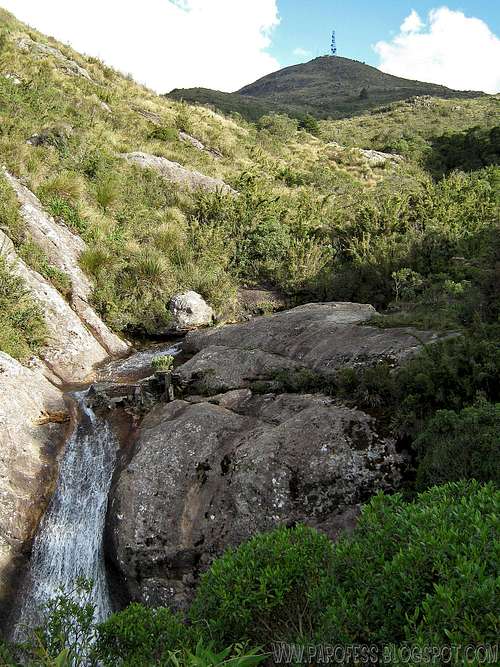
Quite nice view...Itatiaia NP, 2009.
The mountainous place is ideal for long and amusing hikes in the midst of landscapes of singular beauty. Altitudes vary between 700 and 2792 metres.
It is considered the first national park in Brazil for the preliminary data concerning its creation goes back to the beginnings of the XX century. The Pico das Aguilhas Mountain, the fifth tallest of the country, is located in this natural reserve between the limits of Minas Gerais and Sao Paulo.
After a failed project the then Biological Station of Rio de Janeiro's Botanic Garden became a National Park in July of 1937, during the mandate of president Getulio Vargas, with an area of 12 thousand hectares. Its extension was enlarged to cover 30 thousand hectares in 1982.
Weather Forecast
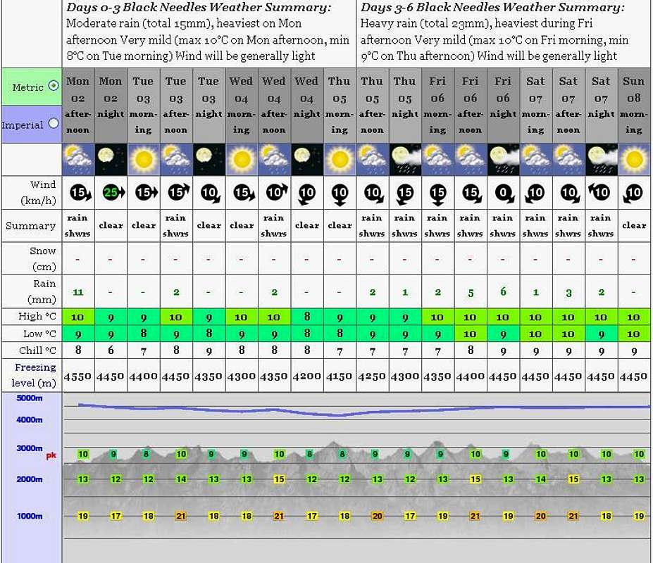
PS: The weather forecast on this link is not for this mountain but it will do just fine since the mountain from the forcast (Black Needles) is just a few kms away from it.
Legal Issues
To hike/ climb is a dangerous activity and requires proper equipment and clothing, the owner of this page cannot be blamed by injuries caused to anyone who read this page for its info about the mountain, and eventually got hurt by doing so with reckless behaviour or bad weather conditions.
Paulo Roberto Felipe Schmidt – AKA: PAROFES
External Links
My youtube channel: www.youtube.com/parofes - Now with 270+ videos online!
The biggest brazilian website about climbing and mountaineering, for which I'm a columnist: