
-
 4797 Hits
-
 77.48% Score
-
 8 Votes
|
|
Mountain/Rock |
|---|---|
|
|
28.13758°N / 14.30991°W |
|
|
Hiking |
|
|
1381 ft / 421 m |
|
|
Overview
 Morro de la Cagada seen from Degollada de Pecenescal Morro de la Cagada seen from Degollada de Pecenescal |
The rugged Jandia Chain in the south of Fuerteventura does not offer too many mountain destinations which actually can be reached. While the south sides are smooth slopes the north faces drop steeply (sometimes overhanging) towards Playa de Barlovento, the island's most beautiful (since undeveloped) beach. Pico de la Zarza, Fuerteventura's highest mountain, is one of these mountains but a look at any map will tell you it is the only one. However, with the proper peak-bagging attitude and a will to ignore regulations you can also rather easily climb another mountain in the north-east of the chain: Morro de la Cagada.
Fuerteventura is the oldest of the Canary Islands. First volcanic eruptions might have occurred as early as 70 million years ago and the island broke the surface of the sea 20 million years ago. In the following ages three giant stratovolcanoes (not unlike Teide on Tenerife) with elevations around 4000m were piled up very quickly. So quickly indeed, that all of them collapsed (which is not unusual for the Canaries where there is a long history of giant landslides). The remainders of two of these volcanoes are still around today, the Betancuria Range in the centre of the Island and the Jandia Chain in the very south.
 |  |  |
The chain stretches south-west to north-east and Morro de la Cagada is located close to its north-eastern end close to one of Fuerteventura's sand deserts, El Jable. It is located close to a popular hiking trail through Barranco de Pecenescal, which ends in Degollada de Pecenescal, a saddle right next to our summit. In fact, a steep and highly eroded hiking path leads down from the saddle to the sea and pristine Playa de Barlovento. Thus a beautiful hike can be combined in a bath (take care of the waves and undercurrents!) as well as a scenic ascent to a standalone mountain.
 |  |  |
Being a part of Parque Natural de Jandia, strictly speaking, Morro de la Cagada should be off limits. However, cars and beach buggies are everywhere on the peninsula so that the ascent of the mountain can only be seen as a minor disgression. From the saddle you have to follow the south-west ridge all the way to the summit. The going is easy for most of the way, though the ground is very soft and shifting. Halway up the mountain you'll have to negotiate a very steep section by turning away from the north-west face and heading for the shallower south slopes. Above the section return to the ridge for the final metres to the summit.
At 421m Morro de Cagada is far from imposing. Still, on an island the highpoint of which reaches only 812m you still are ensured wonderful views. The Jandia Chain in the south-east and the Betancuria Range in the north-east can be seen. Also the sea of sand, El Jable, in the narrowest part of the island is very close, more or less right underneath the summit.
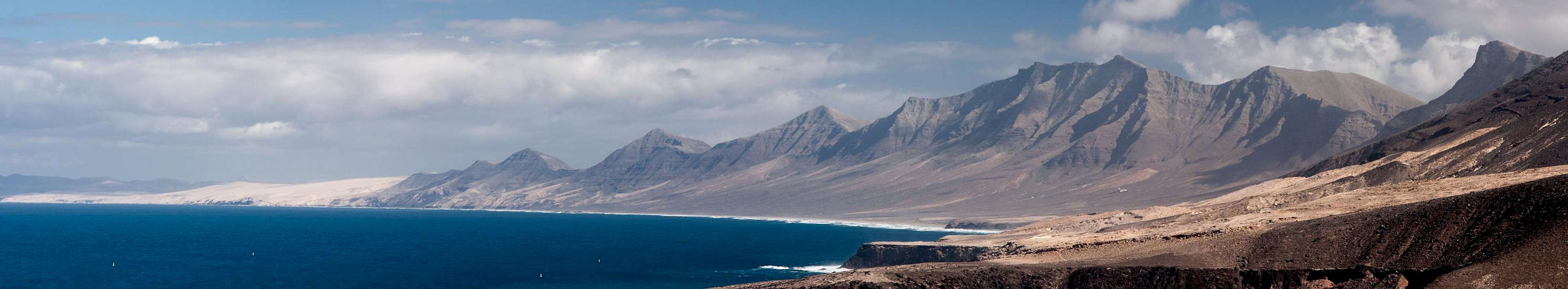
Jandia Panorama from Punta Pesebre
  |
Getting There
 Barranco de Pecenescal with Morro de la Cagada at the end
Though there are ferries from the Spanish mainland to the Canary Islands, they take more than 24h for the trip. Therefore almost all visitors go by plane. Every travel agency in Europe offers flights, hotel rooms, apartments, rental cars etc. so that reaching the Canaries is rather a matter of money than opportunity. During the summer season flight fares can be reasonable but during the Easter and Christmas holidays you have to be prepared for additional fees of 500€ per person.
Fuerteventura has its own airport south of the capital Puerto del Rosario close to the center of the island. There are public bus lines but – like on all the islands – they don't run too regularly. If you plan to stay on your own, better take a rental car right at the airport.
The trailhead for Morro de la Cagada is directly on FV-2, the main road connecting Puerto del Rosario with Morro Jable. It is at km 73, about 1km south of the intersection to Risco del Paso. In this spot a dirt road runs north-westward into Barranco de Pecenescal. You'll have to follow the valley all the way to Degollada de Pecenescal, where the pathless ascent to Morro de la Cagada starts.
Red Tape
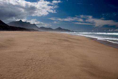 Playa de Barlovento, Fuerteventura's least frequented beach
Morro de la Cagada is located in Parque Natural de Jandia close to the desert of El Jable. There are no obvious restrictions other than construction being prohibited. In general you are asked to stay on roads. Take special care during the final ascent as the ground is very soft and can be shifting.
Accommodation
For holiday homes, hotels or apartments either consult your nearest travel office, or – search for lodgings on Google. There are several sites on the web, dedicated to rent privately owned houses or apartments. Prices are generally a bit less expensive than for tour operators but you don't have as much security.Weather Conditions
Fuerteventura is usually swept by fierce north-western trade winds. Though they deposit their humidity on almost all of the other Canary Islands, Fuerteventura (as well as Lanzarote is simply too low to form a decent obstacle. Therefore the climate is very arid. However, winds regularly are pretty strong,, especially on the mountaintops. It pays to take warm wind-stopping clothes with you. On the Jandia Chain, of which Morro de la Cagada is a part there are strong thermic conditions as well. The winds are forced to rise rapidly across the steep north faces of the chain, which causes some sort of "elevator effect". These conditions often lead to clouded mountaintops during the second half of the day. Therefore never start to late on your climb to the mountain.For some time of the year, eastern winds prevail, which almost always carry clouds of Sahara dust with them. Usually this means reduced visibility but in some occasions "Kalima" occurs. Fierce storms take up the dust from the Sahara and sweep it across the islands. In these times visibility is nil and sometimes even airplanes have to be grounded.
Maps & Books
Maps
Regular Maps
- Fuerteventura
Kompass Map WK240
Kompass Verlag
1:50000
ISBN: 978-3-85491-174-6
Digital Maps
Kompass is the only company known to me which offers GPS digital Maps. In addition for those of you with Garmin GPS receivers there is a map source map set of all Canary islands out there.
- Fuerteventura
Kompass GPS4240
Kompass Verlag
ISBN: 978-3-85491-222-4
- Islas Canarias
Map Source custom map
By Manfred Pepper
downloadable zip-file
Books
My recommendation is a guidebook by Rother Verlag, available in German. The book is an excellent hiking guide covering all the interesting areas of the island. Since it comes with small maps for each excursion it might even be used without a map to support them.
- Fuerteventura
Rolf Goetz
Rother Verlag
ISBN 978-3-7633-4303-2