
-
 8048 Hits
-
 79.04% Score
-
 10 Votes
|
|
Mountain/Rock |
|---|---|
|
|
28.41204°N / 14.07583°W |
|
|
Download GPX » View Route on Map |
|
|
Hiking |
|
|
Spring, Summer, Fall, Winter |
|
|
2375 ft / 724 m |
|
|
Overview
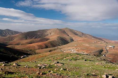 Pico de Betancuria seen from Morro Velosa Pico de Betancuria seen from Morro Velosa |
Named after Jean de Béthencourt, a French explorer, who conquered Fuerteventura and El Hierro for the Castillian court, today Betancuria is a mountain village in the centre of Fuerteventura. Its location in a cauldron of low mountains was chosen to hide it (the island capital at the time) from attacks of pirates. This turned out to be futile even though access was possible only across one of two passes or by negotiating the narrow gorge of Barranco de las Peñitas. Later, Betancuria had to cede the title of island capital to Puerto del Rosario and lost importance quickly.
The the village is surrounded by Fuerteventura's second highest mountain range, called Betancuria Range, a few ridges of round topped mountains, which reaches 724m in its highpoint, Pico de Betancuria. The range is the remnant of something hugely bigger, a stratovolcano of around 4000m elevation, which collapsed and washed away to the sea, forming the shelf, which now appears to form the base of the island. Little can be seen now of this volcanic origin but for occasional basalt rocks and a surprisingly soft soil, which erodes quickly. The Betancuria range as it is today owes its survival to the fact that rain is very rare on Fuerteventura.
 |  |  |
Pico de Betancuria, also Montaña Atalaya, is the highest summit of the little range with Gran Montaña a close second. Both mountains exceed 700m which makes them giants among the hills and volcanoes of the island. Pico de Betancuria is a standalone mountain with two barely separated summits, which is connected only to its neighbour Morro Tabaiba across a short ridge. The remainder of the range forms a circle around the Pico, making it the focal point of any of the views.
 |  |  |
Our mountain can be easily climbed in about 2h from Betancuria. There are two routes, which follow two of the most prominent ridges, the south-eastern one and the eastern one. The latter starrts in Betancuria directly while the former starts somewhat to the south. Both are surprisingly strenuous because of the steepness of the slopes but also because of the soft soil you have to walk upon. The topmost part of the mountain is a kind of plateau, covered with basalt blocks of any size. Its central location ensures some of the best views you can have of the island.
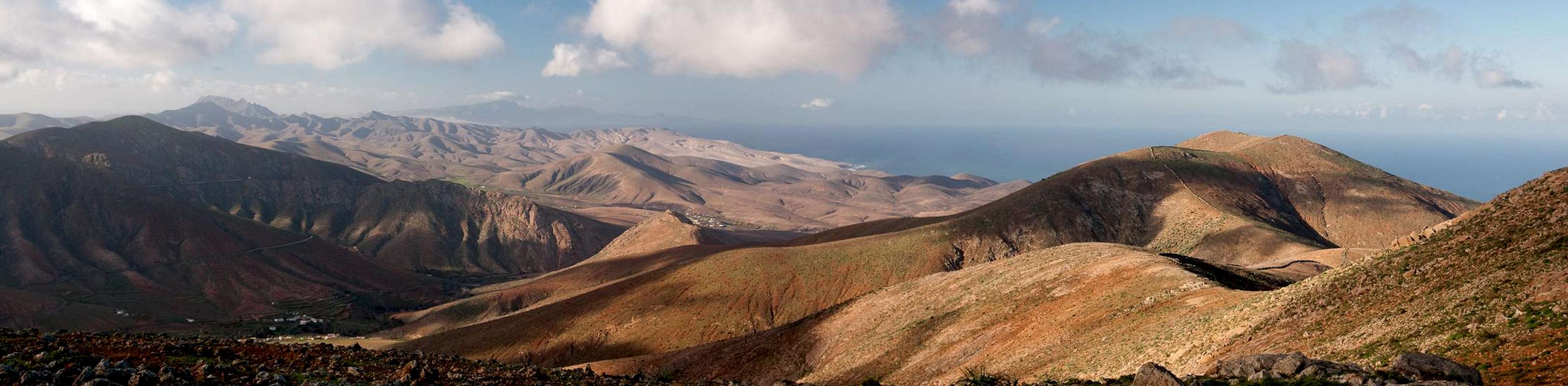
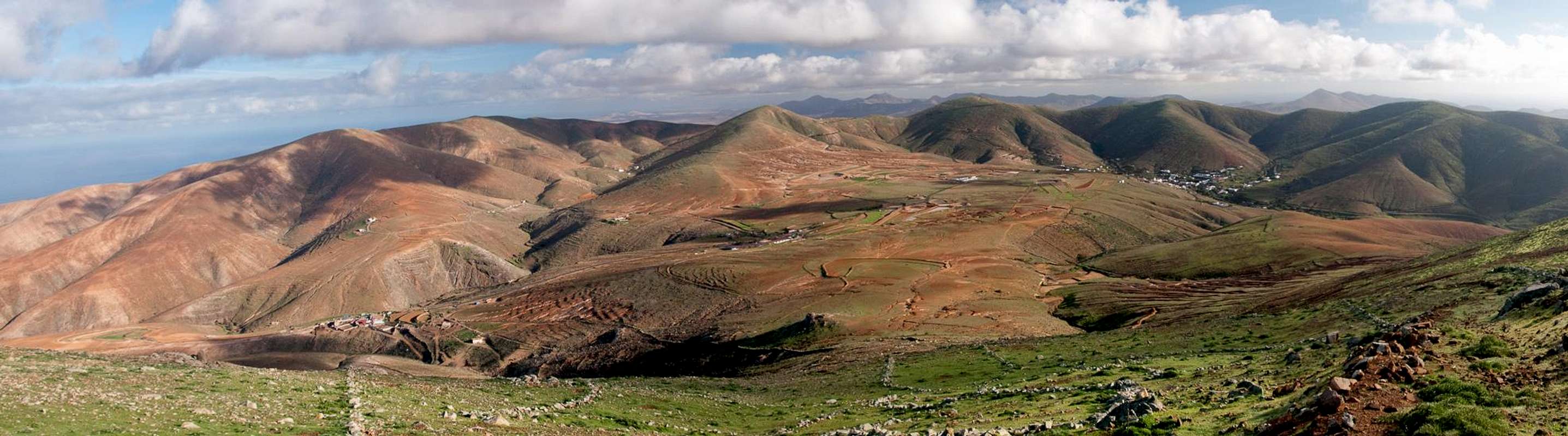
Summit Panorama
  |
Getting There
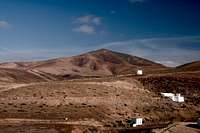
 Morro Tabaiba and Pico de Betancuria
Though there are ferries from the Spanish mainland to the Canary Islands, they take more than 24h for the trip. Therefore almost all visitors go by plane. Every travel agency in Europe offers flights, hotel rooms, apartments, rental cars etc. so that reaching the Canaries is rather a matter of money than opportunity. During the summer season flight fares can be reasonable but during the Easter and Christmas holidays you have to be prepared for additional fees of 500€ per person.
Fuerteventura has its own airport south of the capital Puerto del Rosario close to the center of the island. There are public bus lines but – like on all the islands – they don't run too regularly. If you plan to stay on your own, better take a rental car right at the airport.
There are several starting points for Pico de Betancuria but the old capital itself is closest. Of the two routes one starts right in the village centre while the other requires a short hike along the road to Vega de Rio Palmas. The road is much used so you might want to start early.
- From the airport near Puerto del Rosario take FV-2 south
- Use FV-413 west to Antigua.
- Take FV-30, which will take you across a pass into the cauldron of Betancuria.
- A small but good parking lot can be found at the start of the village.
Red Tape
 |
There's no red tape. However, near the villages there are lots of fields and gardens and the path vanishes among them. Also, there are fences (one leading right up to the summit. Keep them in working condition and respect the property.
Accommodation
 Pico de Betancuria seen across the ruins of the Betancuria monastery
For holiday homes, hotels or apartments either consult your nearest travel office, or – search for lodgings on Google. There are several sites on the web, dedicated to rent privately owned houses or apartments. Prices are generally a bit less expensive than for tour operators but you don't have as much security.
The Betancuria area has not (yet) been developed for tourism so that you won't find big hotels or apartment blocks in the area (though there are lots of souvenir shops). There are inns in the surrounding villages where you might be able to stay for the night. The closest holiday town is Caleta de Fuste on the east coast.
Weather Conditions
Fuerteventura is usually swept by fierce north-western trade winds. Though they deposit their humidity on almost all of the other Canary Islands, Fuerteventura (as well as Lanzarote is simply too low to form a decent obstacle. Therefore the climate is very arid. However, winds regularly are pretty strong, especially on the mountaintops. It pays to take warm wind-stopping clothes with you.For some time of the year, eastern winds prevail, which almost always carry clouds of Sahara dust with them. Usually this means reduced visibility but in some occasions "Kalima" occurs. Fierce storms take up the dust from the Sahara and sweep it across the islands. In these times visibility is nil and sometimes even airplanes have to be grounded.
Maps & Books
Maps
Regular Maps
- Fuerteventura
Kompass Map WK240
Kompass Verlag
1:50000
ISBN: 978-3-85491-174-6
Digital Maps
Kompass is the only company known to me which offers GPS digital Maps. In addition for those of you with Garmin GPS receivers there is a map source map set of all Canary islands out there.
- Fuerteventura
Kompass GPS4240
Kompass Verlag
ISBN: 978-3-85491-222-4
- Islas Canarias
Map Source custom map
By Manfred Pepper
downloadable zip-file
Books
My recommendation is a guidebook by Rother Verlag, available in German. The book is an excellent hiking guide covering all the interesting areas of the island. Since it comes with small maps for each excursion it might even be used without a map to support them.
- Fuerteventura
Rolf Goetz
Rother Verlag
ISBN 978-3-7633-4303-2
Gangolf Haub - Mar 5, 2012 8:27 am - Hasn't voted
Re: Continental drift :)Yes, they drift fast this season :-) Thanks!