
-
 5965 Hits
-
 76.66% Score
-
 7 Votes
|
|
Mountain/Rock |
|---|---|
|
|
28.33324°N / 14.07739°W |
|
|
Hiking |
|
|
Spring, Summer, Fall, Winter |
|
|
1988 ft / 606 m |
|
|
Overview
 Montaña Carbon seen from Morro del Cura Montaña Carbon seen from Morro del Cura |
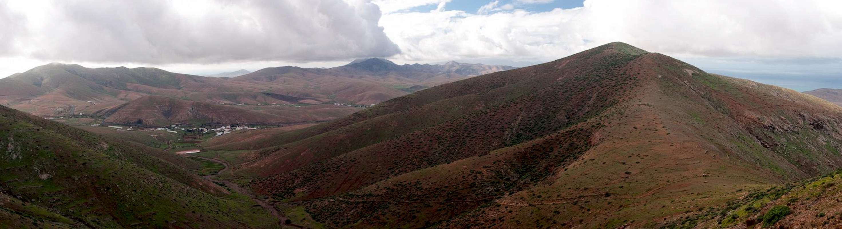
Montaña Carbon is located on the southern outskirts of Fuerteventura's second highest mountain range, the Betancuria Range. With its 606m it is quite tall for Fuerteventura conditions and thanks to its location it is considered one of the best lookout peaks of the island. Still it seems far from popular - the shortest ascent route from Pajara is too long for tourists and too short for serious hikers. The return trip takes about 3 - 4h. Moreover, the actual ascent takes only about half of the time, while the rest is spent in Baranco de Tinarajo, a dried out creek bed which is dusty and in which a lot of junk is lying around.
Once at the end of the barranco, however, the route follows its eastern tributary to a saddle from where a steep and rugged ascent path leads across Morro del Cura to Montaña Carbon. Morro del Cura is a secondary side summit, round topped and barely rising above the sadldle which separates it from Montaña Carbon. Near its top you find abandoned fields and a ruined shepherd's hut, indicators of its agricultural use in forrmer times. Near the saddle to Montaña Carbon the path vanishes among several rocky sections which block the direct route. In addition thorny bushes force you out into the south face of the mountain, where several hundred metres of rock hopping take you back to the summit ridge. There an additional obstacle awaits you: a cattle fence, which only retreats shortly before you reach the broad summit plateau.
 |  |  |
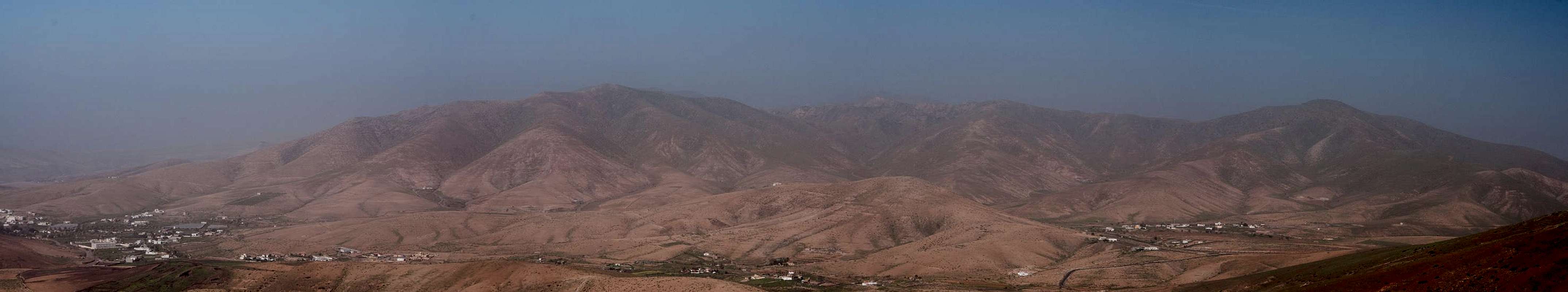
From up there you usually can look across the whole island with the Betancuria Range to the north and the Jandia Range in the far south. In fair conditions that is. We had the bad luck that upon our start in Pajara a Kalima weather pattern started to establish itself. In such a case heavy eastern winds carry Sahara dust across the Canaries and visibility sinks lower and lower. Upon our arrival on Morro del Cura only the Betancuria Range remained hazily visible while on top of Montaña Carbon it was barely distinguishable. Upon our return to Pajara and the subsequent drive back visibility was restricted to a few hundred metres. It is a weird phenomenon not unlike but quite different to fog. Near views appear to be unrestricted whil in the distance a veil seems to block any further view.
 |  |  |
With no views we had to concentrate on closer distances. While Fuerteventura is a dried up desert island winter rain or fog can bring some little humidity. After three weeks of short nightly rains the mountains of the Betancuria Range had covered themselves with a thin green layer. On Morro del Cura and Montaña Carbon wildflowers had quickly used the conditions and blossoms were everywhere. A few weeks later they had vanished like phantoms but at the time they were an unexpected change.
Summit View During Kalima Conditions
  |
Getting There
Though there are ferries from the Spanish mainland to the Canary Islands, they take more than 24h for the trip. Therefore almost all visitors go by plane. Every travel agency in Europe offers flights, hotel rooms, apartments, rental cars etc. so that reaching the Canaries is rather a matter of money than opportunity. During the summer season flight fares can be reasonable but during the Easter and Christmas holidays you have to be prepared for additional fees of 500€ per person.Fuerteventura has its own airport south of the capital Puerto del Rosario close to the center of the island. There are public bus lines but – like on all the islands – they don't run too regularly. If you plan to stay on your own, better take a rental car right at the airport.
The best starting point for Montaña Carbon is Pajara, the seat of the municipality, which can be reached as follows:
- From the airport near Puerto del Rosario take FV-2 south
- Use FV-413 west to Antigua.
- Turn onto FV-20 south to Tuneje
- In Tuneje turn onto FV-30 to Pajara
- Barely inside the town a road turns off left into Baranco de Tinarajo. Park at the end of teh paved road.
Red Tape
 Allium roseum on the summit of Montaña Carbon
There's no red tape here. Part of the creek bed of Barranco de Tinarajo is used as a dirt road but rarely used. Also, mountain bikers use the lower part of the ascent route to Montaña Carbon. Take care not to be in their way.
Accommodation
 |
For holiday homes, hotels or apartments either consult your nearest travel office, or – search for lodgings on Google. There are several sites on the web, dedicated to rent privately owned houses or apartments. Prices are generally a bit less expensive than for tour operators but you don't have as much security.
The Pajara area has not (yet) been developed for tourism so that you won't find big hotels or apartment blocks in the area. There are a few inns where you might be able to stay for the night. The closest holiday town is Caleta de Fuste on the east coast.
Weather Conditions
 Betancuria Range during Kalima conditions
Fuerteventura is usually swept by fierce north-western trade winds. Though they deposit their humidity on almost all of the other Canary Islands, Fuerteventura (as well as Lanzarote is simply too low to form a decent obstacle. Therefore the climate is very arid. However, winds regularly are pretty strong, especially on the mountaintops. It pays to take warm wind-stopping clothes with you.
For some time of the year, eastern winds prevail, which almost always carry clouds of Sahara dust with them. Usually this means reduced visibility but in some occasions "Kalima" occurs. Fierce storms take up the dust from the Sahara and sweep it across the islands. In these times visibility is nil and sometimes even airplanes have to be grounded.
Maps & Books
Maps
Regular Maps
- Fuerteventura
Kompass Map WK240
Kompass Verlag
1:50000
ISBN: 978-3-85491-174-6
Digital Maps
Kompass is the only company known to me which offers GPS digital Maps. In addition for those of you with Garmin GPS receivers there is a map source map set of all Canary islands out there.
- Fuerteventura
Kompass GPS4240
Kompass Verlag
ISBN: 978-3-85491-222-4
- Islas Canarias
Map Source custom map
By Manfred Pepper
downloadable zip-file
Books
My recommendation is a guidebook by Rother Verlag, available in German. The book is an excellent hiking guide covering all the interesting areas of the island. Since it comes with small maps for each excursion it might even be used without a map to support them.
- Fuerteventura
Rolf Goetz
Rother Verlag
ISBN 978-3-7633-4303-2