
|
|
Mountain/Rock |
|---|---|
|
|
48.37500°N / 121.325°W |
|
|
7127 ft / 2172 m |
|
|
Overview
Mt. Chaval is an intriguing mountain every Washington Cascades climber has heard of but few have visited. This is probably because of the arduous approaches, not necessarily the climbing itself (though there are certainly rock climbing routes on it). It could even be surmised that a lot of these climbers don't even know where it is. But they should. Chaval is located immediately southwest of its higher and more massive neighbor Snowking Mountain. Ah, so now you think you know where it is. To be sure, the mountain can be seen from the highway coming into Darrington (there is a good view of it while driving past the cemetery just west of town) and while leaving Darrington heading north before driving into the heavy forest. It is the triple-spired peak on the mountainous skyline northeast of town. Ah, so that's what peak that is: Mt. Chaval.
Mt. Chaval is the alpine culmination of the group of peaks south of the Illabot Creek Drainage. On the south, you'd have to travel about 15 miles before running into a higher peak (Mt. Pugh). Chaval's three summits lie on an East-West ridge. The West Summit (7,127 ft) is highest; the more precipitous Middle and East summits are both measured at 7,040+ ft (both having that as their last contour). The north sides of these peaks are the steepest, but the south sides are no bargain either. Chaval Lake (4,804 ft) is located in a deep cirque on the peak's south flank. Crater Lake (4,471 ft)--yes, yet another Crater Lake--is a little farther to the southeast. The views of Snowking Mountain from Chaval are first-rate.
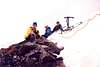
A note about the name: Any serious rock climber is familiar with the cheval move where one has to shimmy along on one's derriere while straddling a knife-edge. Well, Chaval may be an unintentional misspelling of that word or it could be the name of an important figure from the past--perhaps a compatriot of Lage Wernstedt, the man who named many of the peaks in the North Cascades. Keith and Ruth Rankin made the first ascent of "Chaval" in 1946. Since the Rankins apparently did not name the mountain, it was not them who made the spelling error. Plus, if the peak was named prior to its first ascent, then how would anyone know to name it after the cheval move if they hadn't visited it themselves? One could conjecture that the sharpness of its profile from a distance could intimate such a climbing maneuver as being necssary. The only place on the mountain that looked like it might require a cheval would be on the crest of the Middle Summit (see this picture). However, in light of this conjectural unlikelihood, it seems more plausible Mt. Chaval is named after someone who went by that name. Thus, the name Chaval should not be corrected to Cheval. As a side note, to quote from my Webster's: cheval-de-frise -- 1. a defense consisting of a timber or an iron barrel covered with projecting spikes and often strung with barbed wire; 2. a protecting line (as of spikes) on top of a wall. Both of these definitions would aptly describe Chaval when viewed from Darrington or from the north.
 |  |  |  |
Getting There
There are three standard approaches and one non-standard approach to Mt. Chaval. By standard I don't necessarily mean simple. By non-standard, I also don't mean simple. I just mean even longer than standard. To be sure, each is frought with close encounters of the foliage kind. My approach for this climb was via Jug Lake, so this is the one with which I am intimately familiar. However, I deproached by way of "Juggernaut", so can comment on that route too.
 |  |
Jug Lake Approach
From Darrington, drive Hwy 530 17 miles from the corner in town (or drive 2.5 miles south from Rockport) to Illabot Creek Road (FR-16). This dirt and clayey road is in fine shape (better than most Seattle streets, one might quip). Take the ICR for about 16 miles to the prominent switchback at Arrow Creek (2,220 ft). Park here. There is a faint fisherman's path that leaves the road about 20 yards west of the creek. This path parallels the creek through alternately brushy and wooded terrain. There is one brushy boulderfield to cross at about one mile in. Eventually, Arrow Creek (east fork) will widen into a slow-moving stream. A little higher up will be Lower Jug Lake (3,453 ft). From the south side of the lake, cross the feeder stream and bear east into the basin holding Jug Lake (3,907 ft). From the outlet of the lake you will see your next objective above. This is the prominent saddle (6,120+ ft) ESE of the lake. However, due to cliffbands, a direct approach to this saddle is not feasible. Instead, a proven route is by way of the 5,320-ft notch east of the lake. This is the notch immediately south of Pk 5782 ("Juggernaut"). Go around the north side of the lake through forest until the long ravine leading up to the notch is encountered. A stream issues through the ravine. Some rock steps should be expected. We climbed through there in snowed-over spring conditions, so it is hard to say how high or difficult these steps would be. From the notch, turn southwest and climb up and around a buttress then bear SSE to the crest of a spur ridge with cliffy south side. Follow the spur ridge eastward until the south-facing cliff diminishes at about 5,880 ft. The objective 6,120+ ft saddle can now be seen half-a-mile to the south. Descend into the basin south of the spur ridge and then make an angling traverse to the saddle. Ah, at the saddle you will finally get a view of Chaval. However, you've still got some work to do. From the saddle, skirt the south side of Pk 6356 then follow the ridge leading ESE from said peak to the forested low point that allows one to drop into the basin east of said peak. Turn to the ESE once in the basin and contour below the crags toward Chaval. Continue easily to the short West Face of Chaval. In spring or winter conditions, the face is nothing more than a steep snow climb (pickets advisable). In snow-free conditions, there is supposedly a ledge that cuts across the face to allow access to the upper southwest corner of the peak. We never saw this ledge due to snowcover. We completed the climb by going straight up the face on its north end. Once atop the face, a short traverse right along a cornice leads to the high point. In winter and spring, the "highest point" may be a dome of snow dangerously corniced on the northeast side. Reverse the route home.
 |  |  |  |  |
Juggernaut Approach/Deproach
We went back this way, but it is feasible as an ascent route. Instead of stopping at Arrow Creek, continue 2 more miles on Illabot Creek Road to the bridge over Illabot Creek (2,400 ft). Backtrack along the road northwestward about two-tenths of a mile. Leave the road and make the most suitable angling ascent up the forested slope. One should expect to cross many minor drainage gullies. Bear southward so as to get to the basin immediately northeast of Pk 5522. Ascend to the 5,120+ ft saddle east of Pk 5522. Contour along the south side of the ridge below Pk 5782, bearing to the 5,320-ft notch described in the Jug Lake Route. Continue to Chaval as per that route. This route can be used as a deproach back to the road if you don't think you want to deal with the Arrow Creek brush on the return. It just means you'll have an extra two miles of road walking to do between "trailheads."
 |  |  |  |  |
Bluff Lake Approach
This approach is often used though I have no first-hand experience of it. And so I shall refer you to Dale Flynn's route information. Thanks, Dale.
"From Darrington, drive north on Hwy 530. Take Suiattle River Road east 6.4 miles. Turn left onto unmarked, but excellent, Grade Creek Road. Drive Grade Creek Road for 4.0 miles. Angle right onto abandoned spur road (FR-2643) and park in clearing (can drive another 1.4 miles only with very high clearance and 4 wheel drive). Walk about 2.2 miles on spur road. Where sharp switchback goes up and left, leave road on right and traverse onto old fisherman's trail at 3,100 ft. Trail is hard to follow at times, with many ups and downs, but is very worthwhile. It contours E, then NE, to Bluff Lake (3-5 hours).
Pass Bluff Lake on north side. Ascend N through forest (to avoid cliffs), then E to Cliff Lake at 4,700 ft Ascend open slope N, turn NE when above trees, to 5,600 ft. Contour E across basin and pass just below buttress of major spur ridge. Turn N and contour along east face of that spur ridge at 5,600 ft until dropping slightly down into the next basin. Ascend NE across basin to enter, and ascend, steep gully leading to pass in ridge at 5,920 ft. Cross over to the N side of ridge and go E, probably on snow, to West Face of summit block. Take large, obvious ramp that ascends the face from left to right to summit ridge. Turn left and scramble to summit. Class 2-3.
Notes: Good camps at Bluff and Cliff Lakes. Summited on 7/23/05. Crampons almost needed, but not rope. From Bluff Lake: 6.5 hours up; 4.5 down. Many would do it faster than us, if no route finding problems. With the athletic hike in, steep sidehilling, and exposure, this is not a trip for the casual or timid scrambler. We enjoyed a three-day trip; it has been done before in one loooong day ."
 |  |  |
South Approach
This is the non-standard approach. Suggest you read Beckey's description. It would be long but scenic. I dare not elaborate too much but it is done by way of a traverse from Hurricane Peak (see Huckleberry Mountain Trail).
 |
Red Tape
Mt. Chaval is in the Glacier Peak Wilderness so standard wilderness policy applies. The starting points for these climbs are not official trailheads, so you won't need to worry about that pesky Trail Park Pass.
When To Climb
You could conceivably climb this peak at any time of year provided you could drive to the "trailheads" (~2,300 ft). Daylight is of the essence. It is possible to do this climb in a very long day (14+ hours), but two days is more leisurely. In winter and spring you have shorter days and possible avalanche dangers. The Jug Lake Approach would make for a nice ski tour. In summer (and fall), lack of snow over brush may hinder expedient travel, but the days are longer. Probably the best time to climb Chaval would be May - July.
Camping
Good camp locations:
Jug Lake -- with heavy packs, takes maybe about 3 hours to get to by way of Arrow Creek
Notch 5320+ south of Pk 5782 -- takes about 4 hours to get to by way of Arrow Creek or Juggernaut Approach
Saddle 6,120+ -- takes about 5 hours to get to via Jug Lake side or maybe 4 hours via Bluff Lake (access to a water source may be a problem later in the season)
Bluff Lake -- 3-5 hours from car
Cliff Lake -- 3.5-5.5 hours from car
There are certainly other possibilities. All of the above are by no means designated sites.
Mountain Conditions
Localized Forecast
Other peaks in view from Chaval
 |  |  |  |  |
Miscellaneous Info
 |  |  |
alwaysbeforaging - Sep 25, 2017 11:29 am - Voted 10/10
Red TapeNote that the spur road No. 2643 to the Bluff Lake Approach is being decommissioned per the forest service personnel we met on the road and may require a 1-2 mile road hike to the fisherman's trail.
Klenke - Sep 25, 2017 3:28 pm - Hasn't voted
Re: Red TapeDo you know the point at which they will start to decommission it? At the 2643-ft junction (yeah, the same number as the spur road!) or farther back down the road? Last year when I clmbed Betty's Jugs there was a significant blowdown a couple of hundred yards before that junction.