
|
|
Mountain/Rock |
|---|---|
|
|
48.24310°N / 120.6953°W |
|
|
8320 ft / 2536 m |
|
|
Overview
Flora Mountain is another one of those hard to get to Top 100 summits that rewards you when you finally do get there. The mountain only barely makes it on the list (ranking 98th on the 400P list and 100th on the Bulger list). I suppose if it had been measured at a mere one foot lower it wouldn't even be on the Bulger list and would therefore be relegated to even greater obscurity. But obscurity is unfair for this little gem of a talus pile. Okay, the mountain resides in a lovely alpine environment, is quite attractive looking from certain angles, and has a nice view from its top. Peggy Goldman told me it was her favorite Top 100 climb and Roy McMurtrey finished the Bulger Top 100 on this bad boy of a peak (in October 2006). The mountain's reviling aspect is the not-so-nice gneiss: loose rubbly stuff tending toward annoying talus and scree on lower-angle slopes.The mountain is located in the Stehekin Triangle approximately six miles south of Stehekin. The mountain looms over Lake Chelan, rising 7,200 vertical feet in just 3 horizontal miles, and can be seen from the ferry.
As previously stated, the mountain is a fine viewpoint. This is because it is the highest summit for a radius of five miles (Devore Peak being the nearest higher neighbor) and it possesses 1800 feet of prominence. The remarkable view would be that of the upper portion of Lake Chelan. In fact, if you time it right, you can be at the summit and watch the lake ferries cross paths, such as was the case for us on nearby Castle Rock.
The Flora massif is saddle-shaped. The highest point is on the south end. A northern point (called Fauna Peak by some) is about 100 feet lower. There are no long buttresses or high cliffs on the massif though the north side of the south summit is steep and craggy enough to form an impasse for a traverse, forcing one far below the slabby and rubbly east face or up a narrow gully on the lower west ridge. The southwest side (the standard route) is a mere talus boulder hop.
So what's with the name Flora? Certainly the mountain is too alpine, too barren, to harbor floral arrangements. I think I read somewhere the name comes from a woman's name, no doubt the wife of a local settler.
The first ascent was on September 11, 1940 by Joe Leuthold and Eldon Metzger (now there's two familiar last names for you; well, for Pacific Northwest climbers, at least).
 |  |  |  |  |
Getting There
So the mountain is hard to get to, eh? Why would you want to bother then, right? If you're a Top 100 peakbagger, you'll definitely want to read on because, contrary to what Goldman's guidebooks say, the easiest approach to the mountain is not from Holden. It is from Stehekin via the Devore Creek Trail. But I'll provide the Holden approach too. Stephenson's guidebook gives a suitable description from Devore Creek.The first order of business is to find one's way up Lake Chelan. See the Getting There section on the Dark Peak page for specifics.
 |  |  |  |  |
Devore Creek Trail
For the easy route (the one from Stehekin, not from Holden) you need to hike up the Devore Creek Trail.Note that Flora Mountain can be combined with nearby Devore and Tupshin peaks for the Top 100 afficianados. All can be climbed from the same camp at 5,800 ft in the Bird Creek drainage or from a camp on the Devore Creek Trail called "Bird Creek Camp" on the GreenTrails map. Allow one full day per climb (although fast, efficient climbers can pick off Devore and Tupshin in one day).
Take the $5 shuttle bus (or catch a ride or ride a bike or walk it) from Stehekin Landing 4.4 miles up the road to Harlequin Bridge (rust-colored). Cross the bridge and continue for 300 yards, going past the Harlequin Camp road on the left to a wye. Go left at the wye and follow the road around past the town maintenance yard to the Stehekin Airport (grass airfield). Follow a dirt track southeastward on the east side of the airfield to its corner. The Stehekin River Trail more or less starts here. It first crosses on boardwalks over marshy ground to the other side of the airfield to a trail junction. Go left at the junction and follow the mostly flat trail southeastward for 3 miles to the signed Devore Creek Trail junction (1,160 ft). This junction coincides with the short trail continuance to Weaver Point on the shores of Lake Chelan.
Special note: If you take a float plane to Stehekin you can arrange to be dropped off at Weaver Point thus saving 3.7 miles of flat valley walking to get from the Stehekin River Road to the start of the Devore Creek Trail. The only stipulation is that your party size on the plane has to be least two people.
The trail first ascends in 30-something switchbacks in approximately 2 miles to reach the Glacier Peak Wilderness boundary at 2,300 ft. I'm referring to the point where you come upon the wilderness sign, not the supposed boundary as shown on maps. After that, with a brief respite from the up, you'll be thinking your work is done for the day. But, ah, not so.
For the next 3+ miles the trail climbs up and up and up, never easing off. To make matters worse, the trail does not see much traffic and is therefore brushy in the middle third. It's never hard to follow just that the encroachment from the sides adds to the insulting incline. Your imprecations would be even louder if the brush were wet too.
As a helpful hint, if you can manage it, do the trail in the late afternoon when the sun has descended behind the mountain slope. It's a grind and who needs the thermal truncheon above you adding to your woes?
Finally, at about 4,100 ft, the trail enters significant timber beyond a creek (the creek draining the east side of Tupshin). Shortly thereafter the trail reaches Bird Creek at 4,200 ft. Bird Creek Camp is about 50 yards before the creek crossing. It is the ONLY designated camp in that area of trail. There is space enough for three tents + a cook area. This is a good staging camp. Unless you will be carrying over to Holden, there is no real need to hike farther up the trail for a closer camp. That is, you should be able to climb Flora from Bird Creek Camp and back in one long day.
From Harlequin Bridge, allow for 4 hours to get to Bird Creek Camp.
For the rest of the climb see the Route from Devore Creek.
 |
Route from Holden
This is the route from the southwest. It is much longer than the route from Devore Creek. Certainly a carryover can be done from Devore Creek to Holden via Flora, so inclusion of this route seems necessary.To get to Holden (3,200 ft), instead of taking the ferry all the way to Stehekin, disembark at Lucerne. A bus will shuttle you up to the village. There is a fare for the bus. I think the fee is $5 (cash only).
If you have no reason to go all the way to Holden, you can ask the bus driver to drop you off at the mouth of Tenmile Creek about 0.7 miles before town. A trail leads up to a falls. A continuing trail beyond the falls leads up the creek. This trail is not on the USGS map but is pretty well defined as a boot tread on the west side of the creek. Cross into the Glacier Peak Wilderness about a mile beyond the falls. At about 4,600 ft cross the creek and bear NNE up the west side of the creek draining from Tenmile Pass. At approximately 5,200 feet hit the Company Creek Trail (which is not in Company Creek at this point) and follow it up several switchbacks to the 6,500-ft pass.
From Tenmile Pass the route becomes tortuous. It may be possible to climb up the ridge east of the pass but the proven route is to descend about a mile off the north side of the pass in Devore Creek until it is feasible to go right (east) into the basin northwest of Riddle Peaks. The idea is to cross over the saddle between Riddle Peaks' main summit and Pt. 7990, which is one mile east of Tenmile Pass. The east side of Pt. 7990 is steep and will constitute the crux of your day (Class 3/4). Pick your way down and across the ugly terrain. It may also be possible to head north over Pt. 7990 staying on the crest as much as possible. Your objective is the Riddle Creek-Castle Creek divide at 7,400 ft. It now possible to stay on the crest all the way to Flora but expect varied terrain of varied rock and difficulties. The alternative is to descend into Castle Creek several hundred feet (to as low as 6,800 ft) to avoid the steep, rocky terrain immediately west of Flora at the head of the creek. Basically, take the line of your choice: stay high to avoid elevation loss but deal with harder traversing. Either way you'll eventually find yourself in the lovely parkland basin southwest of Flora's summit. From there simply hike up the talus slope to the top.
Allow 5-6 hours from Tenmile Pass with maybe a total of 6,000 feet of gain depending on your enthusiasm for difficulty versus elevation loss.
Red Tape
There is no red tape for this part of the Glacier Peak Wilderness. Leave No Trace ethics should be prescribed to.When To Climb
Flora could potentially be a good spring ski. As soon as access to Holden is possible, you can get ski it from there. Flora could be skied from Stehekin in the dead of winter. But these would be laborious trips for folks much more capable and discerning than what my description here could muster. Beyond that, Flora is a summer and fall kind of climb.Camping
For the Devore Creek approach, the best camp spot is at Bird Creek Camp (see the Devore Creek Trail section). This is the first viable campsite one arrives at on the trail from Stehekin. There are other sites farther up the valley. Good camping is also availabe in the flat of Castle Creek but there's no point in lugging heavy gear over to there unless you have a reason to (as if to carryover).For the Holden approach, good camping is available at or near Tenmile Pass.
Mountain Conditions
Localized ForecastStehekin Forecast
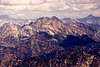
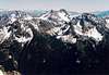
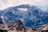
Views from the Mountain I
 |  |  |  |  |