
-
 54472 Hits
-
 83.61% Score
-
 17 Votes
|
|
Mountain/Rock |
|---|---|
|
|
44.13660°N / 71.3331°W |
|
|
Hiking |
|
|
Spring, Summer, Fall, Winter |
|
|
3119 ft / 951 m |
|
|
Overview
A relatively easy hike of 5 miles (round trip) and a 2,100 foot ascent. Summit offers spectacular 360-degree views, including the Presidential Range and Crawford Notch. A good beginner hike.
At 3,119 feet, Mount Crawford shares the Bemis Ridge with lesser known peaks Mount Hope and Hart Ledge. Mt .Crawford is the first peak ascended by the historic Davis Path. The trail leading to the summit was constructed as a bridle path, so grades are easy to moderate all the way to Mount Washington, approximately 15 miles from the trailhead.
Note that the Davis Path ascends Mt. Crawford. The Crawford Path ascends Mt. Washington from the southwest over Mt. Pierce.
 |
 |
 |
 |
Getting There

Suspension Bridge over Saco
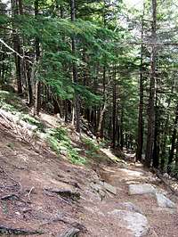
Typical section of trail
Trailhead/Parking
The large Davis Path Trailhead parking lot is located on US 302, 5 miles south of Willey House/Crawford Notch State Park and 12 miles west of Route 16. The Notchland Inn is located almost directly across the street.
Trail
From the parking area, walk north approximately 200 yards down a dirt road and cross the Saco River on a suspension bridge. The trail continues on the far side of the river, uncomfortably close to a house. The next section of the trail traverses through open woods with a few brook crossings.
After passing a sign marking the boundary of the Presidential-Dry River Wilderness, the trail begins to ascend through a thick forest at a constant, but moderate grade. As you near the top of the ridge, the terrain gets steeper, but is moderated by a series of switchbacks. Once on the ridge, you'll be greeted by a bare rock ledge that offers views to the southwest . At a singed junction (2.2 miles), go left over the bare rock on the spur trail to the summit. The trail from the junction to the summit is marked by painted marks and cairns.
For extra credit, retrace your steps back to the Davis Path, and continue northeast to Stairs Mountain for more wonderful views. The two stairs (cliffs) are a prominent feature from the Crawford summit. A jaunt out-and-back from Stairs Mountain will add an additional 5 miles of easy hiking to your trip.
Mountain Conditions
Since the summits of Northern New Hampshire lie in the path of the principal storm tracks and air mass routes, the area above treeline has some of worst weather in the world, and is ecologically similar to the subarctic zone.
To say that the weather can be unpredictable is an understatement. Be prepared for the worst, even in midsummer.
Current conditions reported by the Forest Service.
Although Mt. Washington is over 3,000 feet higher than Mt. Crawford, conditions should be relatively similar (though less extreme) since Crawford's summit ridge is bald. Current and historical weather data and lots of other cool info can be found at the Mount Washington Weather Observatory website.
Hikers often post recent trail conditions at Views From the Top
When To Climb
Early Spring: Mud, crappy snow conditions, and swollen water crossings will limit the enjoy-abilty of this hike
Late Spring: Blackfly season typically runs from late May to early July. Get an early start and hike while they're groggy from the cool morning temperatures.
Summer: Be prepared for mosquitoes and deerflies in lower, flat sections. This time of year can be hot and humid. Summer haze may obscure views. Again, early starts are better.
Autumn: Spectacular foliage from late September to early October. Be prepared to be slowed by swarms of motor-tourists and hikers.
Winter: Due to moderate grades, I would expect this trail to be good for snowshoeing. Days can be crystal clear, or white-out conditions, or both. Due to wind effects, crampons or aggressive snowshoes may be necessary on the bald summit ridge.
Camping
I've stayed at Crawford Notch State Park's Dry River Campground on two separate occassions. I've been pleased each time. There is some traffic noise, but it's not bad. The new toilet, shower, and laundry facilities are the best I've encountered at a campsite. The campgroud is approximately 5 miles north of the trailhead. A general store with food, firewood, and limited camping accessories is located approximately 1/2 mile south of the campground.
New Hampshire State Parks (link)
New Hampshire Campground Owners Association - White Mountains Region (link)
White Mountain National Forest (link)
Red Tape
Backcountry rules for the Presidential-Dry River Wilderness, which is located within the White Mountain National Forest.
Basically, the same rules as the White Mountain National Forest, plus the following rules specific to the Wilderness:
- No motorized equipment or mechanical transport (wheelchairs are an exception)
- Hiking and camping group size must be limited to 10 people or less
- No camping, wood or charcoal fires within 200 feet of any trail except at designated campsites
History
The Davis Path was constructed as a bridle path to ascend Mount Washington in 1845 by Nathaniel Davis, son-in-law of Abel and Hannah Crawford, of Crawford Notch fame. However, the path could not be properly maintained, and it fell out of use within approximately 10 years. In 1910, the path was reconstructed for foot travel.
History of Crawford Notch