
-
 21769 Hits
-
 74.92% Score
-
 5 Votes
|
|
Mountain/Rock |
|---|---|
|
|
47.80800°N / 123.198°W |
|
|
Jefferson |
|
|
Mountaineering, Scrambling |
|
|
Spring, Summer, Fall |
|
|
7139 ft / 2176 m |
|
|
Overview
 Upper Royal Basin is a superb place to camp.
Fricaba is composed mostly of extremely shattered shale which is common to this area. The rock erodes easily and helps lend to Fricabas somewhat rounded shape. This also makes for a lot of scree around the base whick can make for tedious uphill walking.
Five ridges radiate out from the summit of Fricaba -- North, NW, NW, East, and SW. Of the four, the North and SW ridges area the most readily ascended. The basin between the North and NW ridges contains a permanent snowfield and a nice getaway from the crowds in Royal Basin.
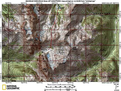
According to The Olympic Mountains Climbing Guide by Olympic Mountain Rescue, the first ascent was by Don Bechlem (NE Peak) and Jack Newman (SW Peak) in 1957. Fricaba didn't seem like a double summited peak to me when I was on top, but my guess is that the SW peak is the true summit and the NE Peak is located at almost half a mile distant on the NE ridge and is quite a bit lower. Take a look at the Topozone map and tell me what you think.
As a side note, Fricaba can be bagged as part of a fabulous loop trip with many, many peak-bagging opportunities. Click HERE for a trip report of the loop. Some of the peaks that can be bagged along the way: Deception, Mystery, Fricaba, Hal Foss, Inner Constance, and Warrior.
A Slide Show of Mt. Fricaba and Royal Basin
Royal Basin and Mt. Fricaba Trip
Getting There
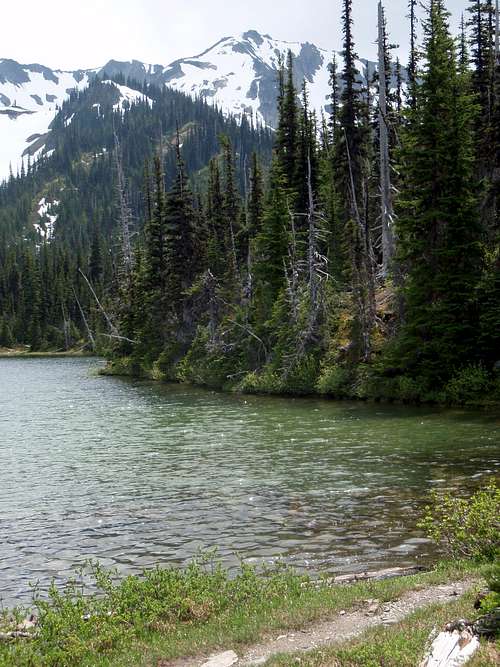 Royal Lake
This depends on whether you decided to come in from the Dosewallips or from Royal Basin.
Royal Basin:
Take US HWY 101 to 1.5 miles west of Sequim Bay State Park or 2.8 Miles east of downtown Sequim. One can also turn on to Louella Rd just accross the street from the park and follow it to Palo Alto Rd. Turn south on to Palo Alto road and follow this about 7 and a half miles to its end and the begining of the FR 2880. About 3/4 of a mile after crossing the Dungeness River, stay left at FR 2870 and follow this to FR 2860. Stay right on FR 2860 and follow this, turning into the parking area to the right just after crossing the Dungeness again. The trailhead is well marked. Avoid the temptation to turn right on to FR 120 for a shortcut. It ends in a washout about a mile from the trail.
Dosewallips:
* ROAD CLOSURE: The Dosewallips Road (#2610) is washed out 4 miles short of the park boundary, 5.5 miles from the trailhead. A trail has been built around the washout. There is no projection for a repair date of the road. Also call 360-565-3131 for road information.
From US 101 in Brinnon, turn on to Road 2610 (which follows the north bank of the Dosewallips River) and follow it just over 13 miles to Constance Creek. At the begining of this road watch for Roosevelt Elk grazing on private land! If you are only doing a day trip (very ambitious if you plan to summit), park here and locate the trail on the north side of the road and the west side of the cascading creek. If you plan to camp, take a quick glance at the meager parking spaces (nothing more than a few cramped turnouts) and continue to the road's end at Muscott Flats (14.7 miles; 1600 ft) to register with the park ranger. Then drive back to Constance Creek and pray that there is still room to park [Olympic Mountains Trail Guide, pg. 133].
Note: Parts of this road are literally blasted out of the cliff. On one particular corner, the road edge drops off abruptly to the river which is a couple hundred feet below. The corner is sudden and it is easy to find yourself staring at the abuss before you realize that you should have slowed down. Combine this with the narrowness of the road, loose gravel, and other idiots sharing the road with you, and you wind up with a great recipe for disaster!
Info for this section taken from "The Olympic Mountains -- A Climbing Guide" and "The Olympic Mountains Trail Guide".
Red Tape
A Parking Pass is required to park at the Royal Basin trailhead.Permits are required for all overnight stays in Olympic National Park's backcountry, and yes, they do check so don't try and get away without one. Camping in Royal Basin requires advanced reservations.
CONTACT INFO for RESERVATIONS and GENERAL QUESTIONS:
Mailing Address: Olympic National Park, Wilderness Information Center, 600 East Park Avenue, Port Angeles, WA 98362
Phone Number: (360) 565-3100 (Permits, Reservations and Information for Backcountry areas).
Email Address: olym_wic@nps.gov (backcountry questions)
Hours: April 1 through May 22, open 7 days a week from 8:00 to 4:30.
Also, to camp in Royal Basin one must carry a bear canister. They can be found at Wild Birds Unlimited or at the Olympic National Park visitor center.
Camping
 Deception Basin
Beautiful camping spots abound for this remote climb. From the Royal Basin approach, one can camp at Royal Lake, Upper Royal Basin, or Deception Basin. Royal Lake is the shortest hike in, but also the most crowded. Reservations are required and it sometimes can be full long in advance. While the lake is a beautiful location, the views will be shared with many other hikers.
Upper Royal Basin is one mile beyond the lake and about 1000' higher, but well worth the effort. A crowded day at Royal Lake can have perfect solitude in the upper basin. It is surrounded by beautiful jagged peaks and pristine meadows. During the spring snow will have to be melted for water, but later in the season there is plenty of running water.
Deception Basin, reached by both Royal Creek and the Dosewallips River, is the closest camp to Mt Fricaba. It offers more solitude and more beauty than Royal Basin, but it comes at a heavy price. The traverse from Royal Basin is steep and requires basic snow travel skills (eg. ice ax, self arrest, etc.) The best camping is on the gravel flats North of Mt Mystery at about 5700'.
 Route from Royal Basin to camp spot in Deception Basin
Upper Royal Basin and Deception Basin have no bear wires, so bring a bear canister. It is required.
Suggested Gear
Ice ax (required early in season, but always nice on the scree)Helmet (esp. if traveling in a large group as there is much loose rock)
Related Literature and Online Info
Olympic Mountains Climbing Guide by Olympic Mountain Rescue.Olympic Mountains Trail Guide by Robert Wood.
100 Hikes in Washington's South Cascades and Olympics by Ira Spring and Harvey Manning.
Trip Report in area from twohikers.org.
When to Climb
Fricaba can be climbed in any season, but late spring or early summer is best. During the winter months, the approach roads for the Dungeness River are impassible due to snow, so the Dosewallips would be the only feasible approach.It has been reported that during late spring, Deception Basin can be dangerous due to the many creeks flowing under the snow, so extra caution is advised.