
|
|
Mountain/Rock |
|---|---|
|
|
47.78410°N / 123.134°W |
|
|
Jefferson |
|
|
Hiking, Scrambling |
|
|
Spring, Summer, Fall |
|
|
7300 ft / 2225 m |
|
|
Overview
Warrior Peak is a double summited peak located on the eastern edge of the Olympic National Park, just south of the Buckhorn Wilderness. The southeast summit is slightly higher at 7300 feet while the northwest summit sits at 7285 feet. These peaks are not visited too often as Mount Constance less than a mile to the south demands much of the attention of climbers in the area. However a strong case can be made that this peak deserves more attention as the climb is excellent and the scenery is wonderful. The approach is long, approximately 10 miles via the shortest route, meaning most intent on summiting Warrior Peak do it in 2 days. The first ascent was accomplished by none other than Fred Beckey in 1945. Apparently Mr. Beckey carved his name in a rock at the saddle between the two peaks, which you may still be able to find to this day. Warrior Peak from Charlia Pass
Getting There
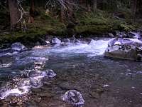 Upper Dungeness River
 Upper Big Quilcene Trail
 First View of Warrior
There are a couple ways to get to Warrior Peak but the two most common approaches are the Upper Dungeness Trail and the Upper Big Quilcene Trail via Marmot Pass. Both routes meet up at Boulder Camp. Click here for a map of the trails leading to Boulder Camp.
Upper Dungeness Trail Approach:
This is the shortest and easiest approach to Warrior Peak.
Follow Highway 101 to Sequim Bay State Park, turn left across from the State Park onto Louella Road. Follow Louella Road one mile to Palo Alto Road and take a left on Palo Alto Road for 1.1 mile to the Forest Boundary. The Palo Alto becomes FS Road 28. Turn right onto FS Road 2880, drive past Dungeness Forks Campground for 1 mile. Stay left onto FS Road 2870 for 8.7 miles to the trailhead across the Dungeness River bridge.
The first 3.4 miles (600 ft elevation gain) along the Upper Dungeness Trail are extremely easy as the trail makes it's way to Camp Handy. From there take the left fork and continue another 3 miles (1850 ft elevation gain) on up to Boulder Camp.
Total Distance to Boulder Camp: 6.4 miles
Total Elevation gain to Boulder Camp: 2450 ft
Upper Big Quilcene Trail (Marmot Pass) Approach:
I'm not sure why anyone would choose this route unless the Upper Dungeness Trail is closed, but I have seen several trip reports indicating that this is a common approach. This route is longer and requires more elevation gain, plus it requires 1000+ feet elevation gain on the return trip. Nonetheless, this route is often taken so I will include it here.
From US 101 1.5 miles south of Quilcene head west onto Penny Creek Road. After 1.5 miles bear left onto Big Quilcene River Road (Forest Road 27). Drive 9.25 miles, turning left on FR 2750. Continue 4.75 miles to the trailhead.
Hike the Upper Big Quilcene Trail 5.3 miles and 3500 feet elevation gain to Marmot Pass. From here take the trail left (south) and continue down 1.7 miles to Boulder Camp (1050 ft elevation loss).
Total Distance to Boulder Camp: 7 miles
Total Elevation Gain to Boulder Camp: 3500 ft (with 1050 ft loss)
Tubal Cain Trail Approach:
A third option to get to Boulder Camp would be the Tubal Cain trail although this is the longest, 10.4 miles to Boulder Camp, and also requires you to go up and down over Marmot Pass. I doubt anyone would use this approach if their goal was Warrior Peak, but it is an option if you are planning an extended trip. Driving directions are the same as for the Upper Dungeness Trail, except you continue on the road another 4 miles to the Tubal Cain Trailhead. To see a map of the trail, click here.
 View from 1/2 mile south of Boulder Camp on approach
From Boulder Camp:
Continue south from Boulder Camp approximately 1.5-2 miles, crossing a few creeks along the way. The last creek is larger than the others and comes from the cirque SE of Warrior Peak. This is your destination. The cross country portion of the approach starts here. At some point that looks good to you start heading uphill toward the cirque. There may be bushwacking involved but this can be avoided by continuing on past the final creek until you reach a boulder field. As soon as you see boulders start heading up and back left towards the creek. Follow under a band of cliffs and continue up the boulders approximately 1 mile and 1200 feet elevation to the cirque at ~5900 feet. This is the start for the majority of the routes for both summits.
 Boulder field en route to the cirque Boulder field en route to the cirque |  Inner Constance from cirque Inner Constance from cirque | 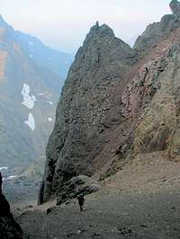 Climbing up the Route 1 coulior Climbing up the Route 1 coulior |
Route Options
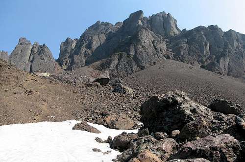 Warrior Peak from the cirque
Southeast Summit - 7300 ft
Route 1 - Class 3-5.2 - From the cirque, head up (north) to the obvious coulior between the peaks. If there is snow it will be somewhat steep, and if melted out it's a brutal scree slog to the saddle. The scree does make for a quick and easy descent though.
Once you get to the saddle head right and climb steep snow or a snow moat to a rock face. The initial climb is difficult and there is some debate about the rating. The Olympic Mountains Climbing Guide has the route listed as class 3. I don't know who came up with this rating, but if I had to guess I'd say it was Fred Beckey. (Beckey is notorious for rating climbs easier than they are.) There are many reports of climbers who attempt or complete this route and have a differing opinion on the difficulty (see trip reports below). Aside from the OMCG I haven't heard anyone who has experience with this route rate this section any lower than class 4. Reports range from class 4-5.2 for about 20 feet once you get to the top of the snow. Once above the difficult section, work your way left to a shallow chimney and scramble up where the route opens up to an easy scramble to the SE summit. You can see a detail of the route here. Most climbers rappel down past the difficult section.
Route 2 - Class 3 - Bypass the large coulior for route 1 and continue to the gully to the far east. Scramble up some rock and aim for a large bench on the right skyline. From here traverse ledges north which will take you to the east face of the peak. Scramble up from here to the summit.
Northwest Summit - 7285 ft
Route 1 - Class 3 - From the cirque climb the coulior to the saddle between the NW and SE peaks. Head left from the saddle up the pile of splintered rock and climb a right angling gully up about 80 feet. This is the hardest part of the climb although it isn't all that difficult. There was a rappel sling toward the top of the gully although I'm not sure you would need to rappel this route at all. In my group of three one was able to downclimb facing out the whole way down and there was one 15 foot section that the other two descended facing in. Once up the first gully scramble up to the base of a scree cone and climb the obvious gully to the summit. The route can be seen in detail here.
Other Routes (NW summit) - The northwest summit can be reached via it's northwest ridge from the saddle with cloudy peak. This route is detailed in the Olympic Mountains Climbing Guide.
  |
Camping
There are several options for camping. Camp Handy, Camp Mystery, Boulder Camp are all possibilities although Boulder Camp is probably one of the more popular camp spots. Boulder Camp is also popular for campers on horses too and may be crowded on a nice summer weekend. The cirque below the summit is also an excellent place to camp and puts you "right there" for a summit in the morning. This is highly recommended. Click here for a topo map location of the cirque.Red Tape
A Northwest Forest Pass is required to park at the trailhead.If you plan on staying within the Olympic National Park boundary a backcountry pass is required. Click here for more information.
Weather
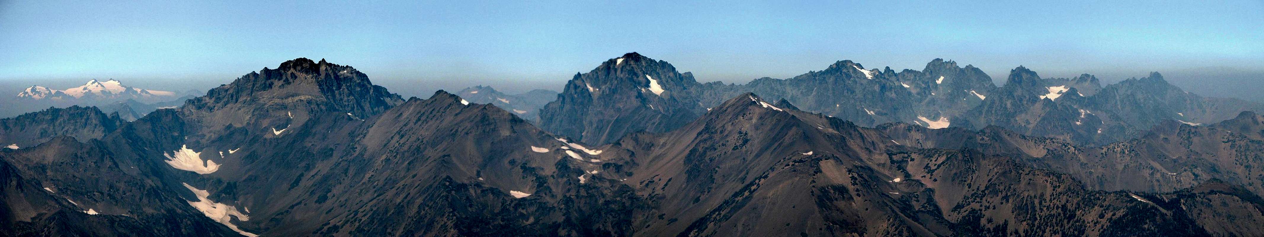
Click here for NOAA weather information and a 7 day forecast of the Warrior Peak cirque area. Sunny, with a chance of wild fires. Northwest summit view - north.
External Links
Trip Reports:- From Cascade Climbers (1) SE summit
- From Cascade Climbers (2) NW summit
- From Cascade Climbers (3) SE summit
- Another trip report
- Trip Report from StephAbegg - Buckhorn and NW Warrior in spring