
|
|
Mountain/Rock |
|---|---|
|
|
37.36060°N / 118.827°W |
|
|
Fresno |
|
|
13361 ft / 4072 m |
|
|
Overview
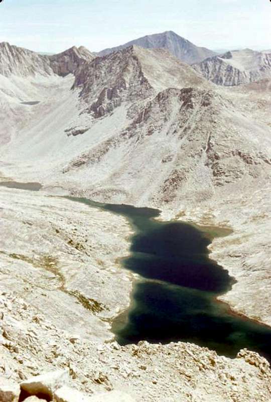
Mount Hilgard is a secluded peak on the Mono Divide in the John Muir Wilderness in Inyo National Forest. The peak is the second highest on the divide, being surpassed by about 400 feet by Mount Gabb located just less than two miles to the northwest. Due to their proximity Mount Hilgard and Mount Gabb are frequently climbed together, and the two are both easily climbed in a day from Lake Italy or its vicinity (see the Route Overview below for a brief description). Both peaks make for imposing sights when seen from across the shores of nearby Lake Italy to the south. Recess Peak sits to the northwest on the opposite end of the Mono Divide but is less commonly climbed with Mount Hilgard due to the intervening terrain. Views include an excellent look at the Mono Recesses to the north, Lake Italy and its environs to the west, and Seven Gables and the Marie Lake basin to the south.Though remote (over nine miles for the shortest approach), the summit of Mount Hilgard can be accessed almost as easily from either the east or the west. Both directions involve several miles of cross-country travel, but they generally remain easy to negotiate. The typical ascent routes are the class 2 Southeast Ridge or the South Slope beginning from near the outlet of Lake Italy on the western shore. Lake Italy itself makes for an ideal overnight destination. The lake is over 11,000 feet high and exceeding a mile long, yet nearly surrounded in every direction by peaks towering over 2000 feet overhead.


Getting There
 Lake Italy and Mount Gabb from the Base of Mount Hilgard
The quickest approach to Mount Hilgard is a cross country approach from Mosquito Flat via class 2 Cox Col just north of Bear Creek Spire. Approaches from Pine Creek via Italy Pass just south of Mount Julius Caesar have also been done. Italy Pass is a bit easier than Cox Col but the trailhead at Pine Creek is about 2800 feet lower. The trailhead differences make Pine Creek more time consuming even though Italy Pass is about 700 feet lower and perhaps more backpacker friendly.
Approaches from the west are also possible, most logically starting out of Lake Edison. There are several options for reaching either Second Recess north of Mount Hilgard or Hilgard Creek to the south, but these are longer than the eastern approaches.
Mosquito Flat Trailhead (37.43516° N, 118.74710° W)
Turn south from Highway 395 onto Rock Creek Road at Toms Place, approximately 15 miles south of the Highway 203 intersection to Mammoth Lakes (23 miles northwest of Bishop). Follow Rock Creek Road 10 miles southwest to the trailhead parking area at the end of the road.
Pine Creek Trailhead (37.36110° N, 118.69184° W)
Turn west onto Pine Creek Road (signed for Rovana) off Highway 395 approximately 10 miles northwest of Bishop (28 miles south of the Highway 203 intersection to Mammoth Lakes). Follow Pine Creek Road 10 miles west to the trailhead parking area.
Lake Edison (37.36735° N, 118.98340° W)
From the Central Valley make your way towards Prather and continue east on Highway 168 towards Shaver Lake and then Huntington Lake, following the obvious road signs. At Huntington Lake, turn right onto well designated Kaiser Pass Road and follow it another 17 miles to an intersection where the road splits to Lake Edison. Turn left at the intersection and follow the road another 6 miles to Lake Edison.
Approaches
As noted above there are several options for approaching Mount Hilgard, with the route from Mosquito Flat being the shortest option. All approaches are class 2. Although the route from Pine Creek is a bit longer and involves more elevation gain the class 2 terrain is a bit easier than Cox Col and it may be preferable for some especially if carrying a heavy pack.Lake Edison makes for an ideal trailhead if approaching from the west side of the Sierra.
| Route | Distance | Gain | Description |
|---|---|---|---|
| Mosquito Flat via Cox Col | 9.2 miles one-way | 5,100 feet +2,000 feet on return | Begin at Mosquito Flat trailhead and follow the well-maintained trail as it climbs slowly (very slowly) into Little Lakes Valley passing numerous lakes along the way. Just before the final 200-300 feet to Morgan Pass (3.3 miles from the trailhead) a side trail turns right (south) towards Gem Lakes. The trail is only maintained for the few hundred yards it takes to reach the last of the Gem Lakes. Continue up a use trail to the left of the inlet stream as it ascends through talus to reach Lake 11320 (the first of several small lakes encountered before Dade Lake). Follow the easiest visible route to Dade Lake and pass the lake on the eastern shore. There are several nice camping options at the north shore of the lake. From the inlet of Dade Lake climb talus and slabs (or snow) up the bowl to the south towards prominent Bear Creek Spire. Cross over Cox Col. Depending on conditions this is normally most easily done at the first notch to the south of the lowest notch left of the rib ascending to the crest. Early in the season ice ax and crampons may be necessary. The west side of the pass is trivial. Descend sand initially and then talus keeping to the north as terrain gets steeper. The route statistics here include dropping down to Toe Lake and continuing around the north shore of Lake Italy to the Southeast Face. It is also possible to pass Lake Italy on the southern shore, or to save about 500 feet of elevation gain each way by keeping high and traversing on benches at 11,800 feet from the eastern side of Mount Gabb all the way to Mount Hilgard. |
| Pine Creek via Italy Pass | 12.2 miles one-way | 7,400 feet +1500 feet on return | From Pine Creek trailhead pass through the corral to the west and hike up the trail as it climbs towards Pine Lake and Honeymoon Lake. Just above Honeymoon Lake (6 miles from trailhead) there is a good camping spot and launching point for the second day summit attempt if not continuing on to Granite Park for the day. Continue on to Italy Pass through Granite Park. The trail is well marked for the first mile or two past Honeymoon Lake, but you quickly reach Granite Park and the trail all but disappears among the boulders. Continue heading west and Mount Julius Caesar and Italy Pass will soon come into view. Ascend easy class two slopes to Italy Pass. Class 2 slabs and talus lead down from Italy Pass to Jumble Lake, with use trails becoming more visible as you approach Jumble Lake. Pass the lake on the north shore and continue north to Lake Italy. Lake Italy is easily passed on the southern shore to its outlet and the base of Mount Hilgard. |
| Lake Edison via Bear Ridge | 13.6 miles one-way | 6,900 feet +1200 feet on return | From the southwestern shore of Lake Edison (near the dam) follow the trail up and over Bear Ridge meeting the John Muir Trail after 5 miles. Continue south on the JMT initially descending Bear Ridge and soon meeting Bear Creek as it heads towards Selden Pass. Long before Seldon Pass, about 8.5 miles from the trailhead and 2 miles after joining Bear Creek, the trail reaches the Hilgard Branch flowing into Bear Creek from the east. An old, unmaintained trail ascends the northern side of the Hilgard Branch just over four miles to the outlet of Lake Italy and the base of Mount Hilgard. If you have four wheel drive the route can be shortened slightly by beginning at the Bear Creek Diversion Dam (the OHV road turnoff is 3 miles prior to reaching Lake Edison and leads 2 miles to the diversion dam). This trailhead saves about a third of a mile each way and 1100 feet round-trip elevation gain (entirely on the return). You can also shortcut the mileage a bit by detouring from the Hilgard Branch prior to reaching Lake Italy and climbing the south slope from where Beartrap Lake’s outlet joins the Hilgard Branch. |
Route Overview
 | South Slope – Class 2 This route climbs directly up scree and talus from the Hilgard Branch from near the outlet of Beartrap Lake. As the slope temporarily lessens betwen 11,600 and 11,800 feet either continue up the loose, sandy gully, or perhaps more preferably aim left for more solid footing on the Southeast Ridge. |
 | Southeast Ridge – Class 2-3 Climb towards the summit initially on solid footing from the outlet of Lake Italy. Once the face begins to steepen at 12,000 feet a sandy chute appears on the South Slope (better used as a descent route). Continue up more solid terrain on the ridge to the right, mostly class 2 but a few class 3 moves are possible. Leave the ridge shortly below the summit and angle northwest across the South Face below a headwall. A short chute leads to the twin summits with the highpoint on the right. |
 | Northeast Ridge – Class 3-4 The Northeast Ridge can be gained via class 2 approaches from either Lake Italy to the south or Second Recess to the north. The ridge itself is up to class 4 and involves passing several gendarmes on either side. |
 | Traverse to Mount Gabb – Class 2 Mount Hilgard and Mount Gabb are frequently climbed together. Because of technical difficulties along the crest of the Mono Divide, this traverse is generally done by connecting the Southeast Ridge of Mount Hilgard to the South Slope or Southeast Face of Mount Gabb using benches at around 11,800 feet on the southern side of the divide. The going is pretty easy and passes fairly quickly on class 2 terrain. |
Red Tape
 Lake Italy from the Summit of Mount Hilgard
Wilderness Permits:
From the east the routes to Mount Hilgard begin on Inyo National Forest land (although the peak itself is in Sierra National Forest). No permits are required for day trips but overnight trips require one throughout the year. Permits for Italy Pass or Little Lakes Valley (Mosquito Flat Trailhead) can be picked up at the White Mountain Ranger Station in Bishop or the Mammoth Ranger Station in Mammoth Lakes. Quotas are in place May 1 through November 1. Check the Inyo National Forest wilderness permit website for the most current information and reservation availability. If approaching from the west in Sierra National Forest check the Sierra National Forest permit website for the most current information.
Food Storage:
No bear canisters are required, but proper food storage is a must.
Campfires:
Fires are prohibited above 10,000 feet.
| High Sierra Ranger District Office 29688 Auberry Rd Prather, CA 93651 (559) 855-5355 | Inyo National Forest Wilderness Permit Office 351 Pacu Lane, Suite 200 Bishop, CA 93514 Wilderness Information Line: (760) 873-2485 Permit Reservation Line: (760) 873-2483 |
Current Conditions
Current NOAA / National Weather Service ForecastWhen To Climb
Spring through fall is the normal season for visits to the summit of Mount Hilgard as the roads to Mosquito Flat and Lake Edison are not plowed in the winter. Pine Creek trailhead is lower elevation (7400 feet) and far more accessible than any of the alternatives in the offseason and would be the best choice if targeting an unusual winter ascent. Contact the Inyo National Forest office in Bishop as needed for road conditions. In some years snow may be present at higher elevations well into spring.
 |
 |
 |
 |
 |
 |
Camping
 Camping by Teddy Bear and Brown Bear Lakes
Mount Hilgard boasts excellent backcountry camping options regardless of which of the several approaches are used to reach the peak. The peak can certainly be climbed as a long dayhike from Mosquito Flat, but passing up a night at Lake Italy is too much for most to pass up. Wide open granite views and peaks surround the mile-long lake… plenty large enough to provide solitude even if others are utilizing any of the numerous locations around its perimeter.
Approaches from Mosquito Flat have many other available options in Little Lakes Valley including Dade, Treasure, and Gem Lakes thought these are more heavily frequented due to their location to Mount Dade and Bear Creek Spire. There are many options along Bear Creek if hiking in from the west, and Granite Park near Mount Julius Caesar is a popular location if coming in from Pine Creek.
Dispersed camping is permitted in both Inyo National Forest and in Sierra National Forest.
Established campgrounds are available throughout Inyo National Forest including a walk-in backpacker campground right at the Mosquito Flat trailhead and numerous drive-in options all along Rock Creek Road. See the Inyo National Forest Campground Camping page for full details. Western approaches offer options at Lake Edison and along the drive in from Kaiser Pass. See the Sierra National Forest Campground Camping page for specifics.
Etymology
 Kite Flying at Lake Italy
“‘Above the valley [of Bear Creek], a bare slope flanks the base of the ridge of peaks of which Mount Hilgard is the most northern. These are several in number. Mount Hilgard from the west is a striking mass, strongly suggesting Castle Peak in Tuolumne County. It was thus named at the suggestion of an admiring former pupil of Professor Hilgard, Mr. Ernest C. Bonner, who accompanied me on one of my outings.’ (Theodore S. Solomons: Manuscript, 1896, p. 66.)
‘The rocks of the First Recess, which opens southward just above the valley, have striking individuality. The granite is very pure and creamy in appearance. Mount Hilgard, named in honor of Professor Hilgard of the University of California, stands at the head of this splendid side gorge.’ (Theodore S. Solomons: Unexplored Regions of the High Sierra, in Overland Monthly, January, 1897, p. 74.) From this it appears that the name was originally given to the mountain shown on the U.S.G.S. map (edition of 1912) as Recess Peak.
Eugene Woldemar Hilgard (1833-1916); native of Bavaria; professor at University of Mississippi, and at University of Michigan; professor agriculture at University of California, 1875-1903; professor emeritus, 1903-1916.
Climbed by Charles F. Urquhart, July, 1905, probably the first ascent. (Letter from George R. Davis to Walter L. Huber, September 14, 1916.)”
– Francis P. Farquhar, Place Names of the High Sierra (1926)
Josh - Dec 30, 2005 3:34 pm - Hasn't voted
Untitled CommentTeddy Bear and Brown Bear Lakes (see photos) are an ideal location to camp enabling ascent from the south and decent betwen Mt. Hilgard and the camp in a day.