
-
 7735 Hits
-
 79.78% Score
-
 11 Votes
|
|
Mountain/Rock |
|---|---|
|
|
37.67630°N / 107.5083°W |
|
|
San Juan |
|
|
Hiking, Mountaineering, Scrambling |
|
|
Summer, Fall |
|
|
13205 ft / 4025 m |
|
|
Overview
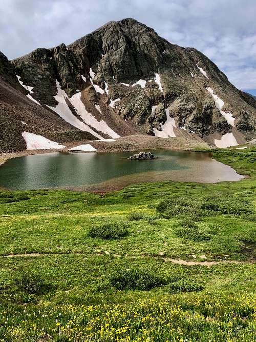
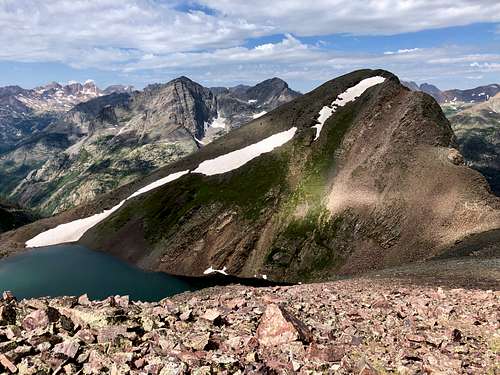 Mount Nebo as seen from the descent of UN 13230 A
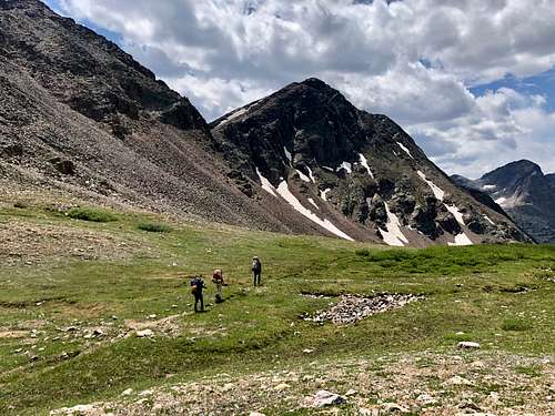 Continental Divide Trail with Mount Nebo in the background
The Guide to Colorado Mountains with Robert Ormes offers a brief mention of Mount Nebo: "From Hunchback Pass, one can climb Mount Nebo (13,205') which affords a marvelous view into the Needles. It can be reached along a 3 mile walk southeast along the divide with one 400' summit to climb or bypass. Or from down on the Vallecito, the best route route starts up a steep watercourse 1 mile north of Rock Creek. After you reach timberline, head a mile northeast for a drink in the 12,500' lake and take the peak by the southeast ridge".
Mount Nebo is very close to be one of Continental Divide Peaks, but the line runs over the nearby Unnamed 13230 A peak. Waters from the east side of the line drain via Rio Grande into the Atlantic and waters from the west side eventually end up in the Pacific.
Colorado Rank: 483
Quad: Storm King Peak
Parent Lineage: 13230
Wilderness: Weminuche
Class: 2 (loose rock)
Nearby Peaks:
- Unnamed 13230 A 0.57 miles
- Unnamed 13110 0.83 miles
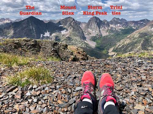
- The Guardian 1.95 miles
- Unnamed 13308 1.97 miles
- Mt. Silex 2.21 miles
- Unnamed 13342 2.34 miles
- Hunchback Mountain 2.36 miles
- Storm King Peak 2.79 miles
- White Dome 2.83 miles
- Peak Nine 2.86 miles
- Peak One 3.05 miles
Please note that Colorado has many Unnamed peaks with just an elevation point. Colorado has 584 ranked 13ers + many more unranked ones, and many peaks have no names. It is just too many peaks and a big project to accomplish to climb them all.
Getting There
The closest 4 WD access is from Beartown/Kite Lake Trailhead.
Driving Directions to Beartown and Hunchback Pass TH (this section of the trail is also Continental Divide Trail): The road is in a pretty bad condition, especially close to the trailhead. Expect about 2.5 hrs drive from Silverton (some sections you will be driving only 1-2 miles per hour).
From Silverton drive on County Road 2 to Howardsville and turn here onto FR 589 marked for Cunningham Gulch and Stony Pass. You have to options here: stay lower or take a higher road for the Old Mine Tour, it does not matter which road you take since they both connect later on. At the point where these 2 roads come together, take a left turn for Stony Pass - well marked.
The road climbs steeply and is narrow at some sections making travel difficult if vehicles coming from the opposite directions (often one car has to back up to spot wide enough where vehicles can pass). Stony Pass is a pretty area, lots of wildflower in the summer, and access to several 13ers. The descent from Stony Pass towards Pole Creek seems dragging, the crossing over the stream can be problematic early in the season. There are great campsites in this area. After crossing Pole Creek, the road goes steeply up and then splits with right fork heading towards Beartown/Kite Lake and left fork towards Creede - again well marked.
Soon, you will be crossing the Rio Grande - it is usually not much deeper than Pole Creek, but wider. It is an experience to drive your car through the Rio Grande River! Some people choose to drive from Creede side, but I think the road is tougher from the east side.
From the Rio Grande crossing, continue on Beartown road for about 5.5 miles. The first section could be muddy with potholes and big puddles. Once you reach the Bear Creek crossing, the road becomes rougher, with lots of loose rocks and towards the end steep. If your vehicle is having trouble, park at the Bear Creek and walk the last mile on the road (I usually drive this section with a speed of 1 mile per hour anyway, so walking may be a better option).
Hunchback Pass Trailhead is well marked, there is a parking spot for 2 cars right there and several more below and above.
Beartown is just a site, there is nothing there! Buy all your supply prior to the trip. Beartown boomed in 1893 when a rich strike brought about 400 prospectors into the area, but it did not last long. They mined Sylvanite.
Route
 Mount Nebo
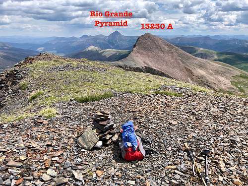 Mount Nebo
The first section of the hike is along Continental Divide Trail, which is easy to follow. Although after the section where Vallecito Trail branches southwest and Continental Divide Trail turn east, there were thick willows and the trail would benefit from some maintenance. Higher up there is a small lake and then larger lake, I reached the saddle between Unnamed 13230 A and Mount Nebo on the south and UN 13110 on the north. I left the trail here and followed the easiest path towards UN 13230 A and Mount Nebo saddle. The first part was easy, then it became rocky and loose. The route was obvious. See the map for more details.
Red Tape
 Mount Nebo
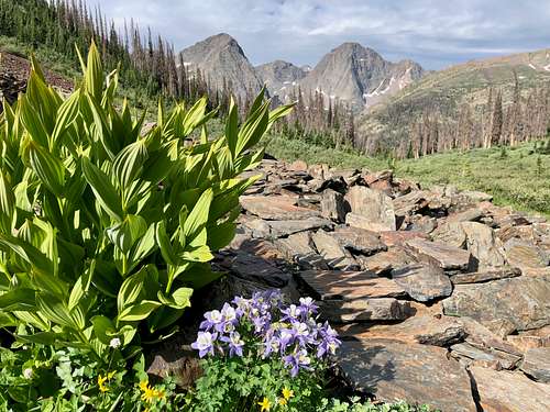 Continental Divide Trail
Follow the seven standard Leave No Trace principles while in the wilderness:
1) Plan Ahead and Prepare
2) Travel and Camp on Durable surfaces
3) Dispose of Waste Properly
4) Leave what you Find
5) Minimize campfire impacts
6) Respect Wildlife
7) Be Considerable of Other Visitors.
Wilderness Specific Regulations:
Group size is limited to no more than 15 people per party.
Camping is prohibited within 100 feet of any water source.
Camping and all campfires are prohibited at the following locations:
1. within 200 feet of Archuleta Lake, Fourmile Lake, and West Ute Lake
2. within 1/2 mile of the north shore and 1/4 mile of other shores of Emerald Lake
3. within 1/4 mile of Little Emerald Lake
4. between the shore and Flint and La Osa Trails at Flint Lake; and within 200 feet of the west and north shores
5. in Needle Creek drainage at Twin Lakes
6. in the hot springs area at West Fork (Rainbow)
Campfires are also prohibited in all of Needle Creek Drainage (including Chicago Basin) and Vestal Basin.
Do not shortcut switchbacks.
Pets must be under verbal control or leashed at all times.
Disposal of human waste and wash water is prohibited within 100 feet of any water source.
As with all designated Wilderness areas, mechanical transportation (including wagons, game carts, wheelbarrows, bicycles, or other vehicles) is prohibited.
When to Climb
This peak is very remote. Winter would mean a very long approach through avalanche-prone terrain. The best time to reach this peak is in summer and early fall.
Camping
There are multiple campsites along the Continental Divide Trail - all primitive in a beautiful nature. Just below Mount Nebe are several nice lakes asking you to spend some time there.
There is also camping at the Hunchback Pass Trailhead and along the Beartown road on your drive in.
Developed campgrounds are very far, e.g. in Silverton and it is about 3 hr drive on rough roads from Bear Town.