Introduction
Since I was on vacation with family in the northeast, I was limited in my choices for days to hike. The only option turned out to be pretty wet. I was hoping for some clearing so that I could get a good view of the White Mountains, but that did not happen. So, I had to be content with a good hike/climb only.
I started from the Mount Osceola Trail's Tripoli Road trailhead, and used that trail to climb Mount Osceola. From there, I continued to East Osceola. At that point, I turned around at returned by the same route.
This was a day on which I needed my good, waterproof rain jacket and my gaiters (since I hike in shorts whenever possible). The air was saturated with moisture because of the rain which had happened the day before, and there were periods of drizzle and rain during the day.
Trailhead to Mount Osceola
![20110613 0715a TH sign]() USFS sign
USFS signThe trailhead has a nice parking area, along with information bulletin boards. The bugs were at their worst here; I had to put on bug spray immediately! However, once I got going I no longer noticed them. The US Forest Service put a mileage sign at the trailhead, but after that there are no markers/blazes on the trail.
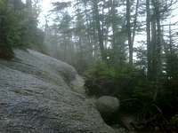
The Mount Osceola Trail almost continuously ascends from the trailhead through the Breadtray Ridge. There are a few switchbacks on the route. It is very rocky at the bottom, and care is needed to place your feet. Some stair construction and erosion control has been done here. At the trail's higher elevations, the surface is exposed rock in some places - though it was not as slippery as I expected it to be.
![20110613 0854]() Exposed rock trail
Exposed rock trail
There are a couple of places where old, now unused trails once joined the Mount Osceola Trail. However, to me it was pretty obvious which trail to follow.
Because of the rain, all of the streams/drainage routes had water running in them, but there was no place that threatened to flood the trail.
![20110613 1123]() Fire tower footings
Fire tower footingsAt the top of Breadtray Ridge, the trail flattens out and I had to dodge puddles. Shortly, I reached the first marker (which is not the summit). There are a couple of side trails here; one might be the way to start for the Middle and West Osceola subpeaks. I continued on to the actual summit, where there is an obvious summit rock as well as the concrete footings where a fire tower used to stand.
It took me about 2 hrs, 10 mins to reach the top. There would have been a great view on a clear day!
Mount Osceola to East Osceola, and back
![20110613 1055 chimney]() The chimney, looking up
The chimney, looking upThis traverse is the most difficult part of the hike. The Mount Osceola Trail continues from the Mount Osceola summit and descends to the col. It starts off pretty easy, but then there is a steep, rocky section going down. Having read about the chimney on this trail, I wondered if this was it and thought that the difficulty was pretty overstated. It turned out, of course, that this part was not the chimney, that was coming up soon! After a flat section, I arrived at the chimney - the real thing this time - and I saw that the difficulty was NOT overstated. This is especially true in wet conditions.
Fortunately, there is a bypass just to the north of the chimney. I decided to be smart and use it. There is a short scramble on the bypass, but it's easy.
![20110613 1023]() East Osceola summit
East Osceola summitAt the bottom is the col between the peaks. The climb to East Osceola was straightforward. At the summit, there is a big cairn and no view (even on a clear day).
The return was pretty much the same difficulty. It was an easy descent to the col for me. I thought about climbing the chimney, but again I decided to use the bypass instead. If it had been dry I might have decided to do it, but one slip could have resulted in a serious injury from falling, and the wetness greatly increases risk.
![20110613 1055a bypass]() Chimney bypass, looking up
Chimney bypass, looking upAfter that, it was a simple climb back to the top for me. There and back took me a little less than 2 hours.
The trail has some old blazes in the East Osceola-to-Mount Osceola direction, colored gold/yellow, between the peaks.
Mount Osceola to trailhead
From the Mount Osceola summit, it is a straightforward descent to the trailhead after leaving Breadtray Ridge. It rained more heavily for a while. The key was to make sure to stay on the trail; as it is not quite as obvious going back in a couple of places where there might be old trails. (The Mount Osceola Trail is not blazed in this section.)
The toughest part was the bottom half, where it was very rocky and I was getting tired! (Living in Michigan kills your mountain hiking abilities, no matter how much trail hiking and elliptical machine work you do.) Hiking poles are an essential piece of equipment for me, in order to go downhill.
Eventually (2 hrs, 15 mins), I got back to the trailhead. It was a good day. Sometimes, all you get is a great hike - and that's enough.
Comments
No comments posted yet.