
-
 9983 Hits
-
 84.27% Score
-
 18 Votes
|
|
Mountain/Rock |
|---|---|
|
|
48.27552°N / 113.51487°W |
|
|
Glacier |
|
|
Mountaineering |
|
|
Spring, Summer, Fall |
|
|
7131 ft / 2174 m |
|
|
Overview
 Mount Shields and Mount St. Nicholas
 Mount Shields from the high but False Summit
Layout designed for best viewing on a "1024 x 768" screen.
Mount Shields is located near the southern boundary area of Glacier National Park. It is located just above U.S. Highway 2 as well as the Bear Creek Drainage and it seems unlikely that there is much open country in this area. Glimpses of stream drainages and occasional dots of open slopes reveal little of the true beauty of this area. The steep-forested slopes seem more suited for elk, which are frequently seen on the slopes opened by avalanches. Looks can be deceiving and Mount Shields does not disappoint climbers!
Mount Shields is an odd peak. The actual summit is not the high point on the ridge. There is no explanation for this oddity but the maps do not lie. The actual high point of the ridge lies 0.7 miles to the northeast and measures in at 7,218 feet (2,219 m) or 87 feet (26.5 m) higher. If you are in to ridge walks this peak is calling you!
This peak is off the beaten path and presents an opportunity to see a portion of the park that is rarely seen. If climbed at the correct time of year this peak presents a bonanza of wild flowers along the lower ridges. It is also possible to spot elk grazing on the side hills while climbing the route.
Mount Shields is a popular backcountry ski destination as well. There is a high risk of avalanche during the winter months so make sure you have the proper equipment and training.
Red Tape
 Elk, Little Dog and Summit Mountains from the route.
Vehicle single entry fee for Glacier National Park is $25.00 for 7 Days, $12.00 per person for single hiker, motor biker or bicyclist. An "America The Beautiful Federal Lands Recreational Pass" for goes for $80.00 which gives entrance to all National Parks, National Forests, BLM, US Fish & Wildlife, and Bureau of Reclamation sites for one year from date of purchase. See Plan Your Visit for other information regarding all of the National Park entrance fee information.
If you are planning on visiting Waterton Park make sure you have a passport to simplify crossing the border.
You do not have to register for day climbs in Glacier National Park but it is recommended. Backcountry travel regulations can be found at Backcountry Travel. There is also information from the Park Service on Mountain Climbing in Glacier.
Getting There
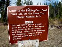 Trail Access Sign
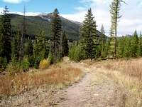 Transition to forest road
 Approaching the Railroad Grade
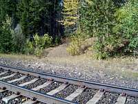 Don't take this trail turn left and follow the tracks!
 The abandoned tunnel that is use to mark the beginning of the route.
This trailhead is located in southern section of Glacier National Park just southwest of Marias Pass on U.S. Highway 2.
To locate the correct road travel either from east or west to mile marker 192. This mileage marker is located just east of the bridge that crosses a point near the confluence of Bear Creek and Geifer Creek.
If traveling from East Glacier, Montana:
Drive over Marias Pass and travel past mile marker 193 be ready to turn right at mile marker 192 before crossing the bridge.
If traveling from West Glacier, Montana:
Drive east from west Glacier, Montana to mile marker 192. Turn left after crossing the Bear Creek Bridge.
After turning on to the usually well graded gravel road travel about 1 mile to the Parking area for the Fielding Access Road Trailhead.
The sign designating the trail head is on the right side and is near a locked gate. Please do not block the gate. This road serves as an access road for the BNSF railroad and you may be in for an unpleasant experience if they have to move your vehicle.
There is ample parking just beyond the trailhead sign.
Trails accessed from the Fielding Access Road Trailhead include: Elk Mountain Overlook Trail, Fielding-Coal Creek Trail and the Ole Creek Trail.
Access to Glacier National Park from this trailhead is allowed by the private landowners that own the land on BOTH side of the dirt road that leads to the park access.
Please respect this land and do not travel off the established road. It would be a shame to loose access to this remarkable area as a result of persons not respecting the rights of the landowners.
The trail starts out near the parking area at the trailhead. After a few hundred feet the trail joins a forest road. Continue up hill for about .75 miles to the location where the forest road meets the railroad grade. Cross over both sets of tracks and look slightly to the left for the trail that takes off into the park.
There is a trail sign there indicating distances to:
Ole Creek Campground (2.5 miles)
Park Creek Campground (7.3 miles)
Walton Ranger Station (10.2 miles)
Ole Lake (12.7 miles)
Do not take the hiking trail towards any of those destinations!
Once at the park boundary follow the railroad tracks to the left (west) for about 1 mile until reaching the abandoned tunnel.
Route Information
 Finally out of the woods
 Ascending the ridge
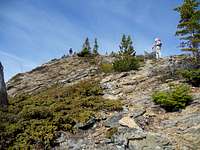 Climb on or near the ridge
 Approaching Point 7218
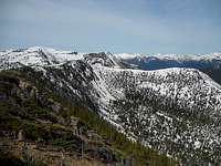 From Point 7218 to the lower summit of Mount Shields
[img:727389:alignright:small:From Point 7218 to the lower summit of Mount Shields]Total One-way Distance: 6.5 miles / 10.4 kilometers
Total Elevation Gain: 4,322 feet / 1,317 meters
Total Elevation Loss: 1,701 feet / 518 meters
Recommended Time For Route: 6-8 hours
Difficulty: G.M.S. Class II (3)
Follow the game trails for nearly 1/2 mile (0.8 km) to the saddle behind the knob marked 5291 (formerly labeled Blacktail Peak on old maps) on the Blacktail quad map. The traveling is not too difficult but it may help to have a compass to help you keep your bearing. The canopy is quite dense and a G.P.S. signal may not be found. The area opens up to a nice meadow.
Climb up ... always staying on the ridge!
Climb to near the cliffs and begin to traverse to the far ridge. There is a distinct elk trail to make the traverse easier … if you can locate it.
Traverse below or on the ridge to Point 7218.
Climbers can either walk on the ridge (recommended) or traverse on the south side of the ridge.
This photo shows the final ridge to Point 7218. This is a Class II climb for the entire route. There is little risk of falling rock with the exception of the elk trail traverse. Even there the risk is minimal.
Follow the ridge to Mount Shields from Point 7218. It is quite an odd feeling to traverse DOWN to a summit, but that is what is required to summit Mount Shields.
Equipment & Camping
Equipment:Bring the normal equipment and the USGS Glacier National Park map is sufficient for this climb.
The USGS quad maps associated with this area are Blacktail and Marias Pass.
There may be little water on this route after leaving the valley floor.
This is bear country! Bring bear spray and know how to use it.
As with all hiking and climbing in Glacier National Park use caution and practice good manners with the wildlife. You are in bear country. Carry bear deterrent spray, don’t hike alone and make some noise. For more information please go to the Park's website for Bear Information. The U.S. Forest Service also has helpful information on Grizzly Bear Management.
Crucial gear includes: water, sturdy footwear and a camera.
Get a Glacier National Park map from a local sporting goods store.
Camping:
Camping is available at the USFS Marias Pass Campground.
Look for the campground just to the east of the Oblisk and rest area.