
-
 32897 Hits
-
 85.87% Score
-
 21 Votes
|
|
Mountain/Rock |
|---|---|
|
|
28.78270°N / 83.92817°E |
|
|
20157 ft / 6144 m |
|
|
Overview
This mountain is the shortest possibility to gain a 6000 m-peak while doing the famous trekking around Annapurna. The highest point of this Trekking is Thorong La (pass), 5416 m. From this pass it is the first mountain to the south.There are no detailed maps available about this area of Nepal (correct me if I'm wrong). The maps you can buy contain south of the pass only a mountain called Khatung Kang (6488 m). But this is not the mountain you can see and climb from Thorong La, but the one behind it. Because of that these mountains often are mixed up.
At least in Germany the mountain is called Thorong Ri. It has for many years been a destination of the biggest organization of germany for guided trekking tours. The height of the mountain is about 6130 m. (This showed my Thommen after I adjusted it at Thorong La). Here they have it - clearly from a map - with 6144m, what should be the correct number.
Here the name is given with "Thorungtse" and the height with 6032m. what is too low. Sometimes you may read "Torongtse" for the mountain, "Thorong Peak" or "Shel Kang"
 |  |  |  |
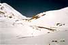
Normal Route from east
From the pass you have to walk and climb about 150 m to reach the beginning of the glacier. The first pitch is the steepest (up to 45°-50°). After that slopes with about 30° lead to a plateau (about 5900 m). Then you have to climb a second step (up to 40°-45°) to gain slopes that become less steep the higher you get and the summit is just an even plateau.After the next pass a sharp ridge would lead to the "real" Khatung Kang which would be by far more difficult and would probably require a high camp.
 |  |
direct route
original submitter Alxsanders wrote:I tried last October with two friends but we were nearly swept off the mountain by a small avalanche. It does not look that hard to climb, but neither a "piece of cake".
I do not have any information about any "normal route". We tried by the north side but maybe there's a chance surround the mountain from the same point (Thorong La) towards the East and try to find out if there's an easier way.
 |
Getting There
The approach to the mountain is identical with the Trekking around Annapurna with starting point either in Jomsom or Besisahar.a) from Jomsom (west side)
(by: Alxsanders)The easiest is to fly- in to Jomson from Pokhara and from this point head-up to Thorong La (pass); passing by Muktinath, and set the base camp right on the pass (which is very windy).
First day you fly to Jomsom and sleep there.
Second day you walk to Muktinath.
Third day you get to Thorong La (pass), and set the base camp.
Take an extra day or days to acclimatize; specially beyond Muktinath. Maybe is good to stay two or three days at Muktinath and hike upwards and return to sleep before getting to the B.C.
 |
b) from Besisahar (east side)
(by eza)Thorung La, the starting point for the north face of Khatung Kang, can also be reached from the east. You need to take a bus from Katmandu to Besi Sahar. From that point on it will take you at least seven days to reach Thorung Phedi following the Annapurna Circuit trek. On the eigth day the ascent to Thorung La should take place. An additional day in Manang is recommended in order to obtain optimal acclimatization. The stages would be:
Day 1.- Besi Sahar - Bahundanda
Day 2.- Bahundanda - Chamje
Day 3.- Chamje - Danakyu
Day 4.- Danakyu - Brathang
Day 5.- Brathang - Manang
Day 6.- Additional day in Manang. Different excursions are possible, including the Gangapurna icefall or Thakchen Gompa (a small buddhist shrine in the hills north of Manang)
Day 7.- Manang - Yak Kharka
Day 8.- Yak Kharka - Thorung Phedi
No lodging problems for small parties in any point of the trail, there are many lodges in every village. Big parties should be able to camp without too much trouble.
 |  |  |  |
Red Tape
For doing the Trek around Annapurna you need a trekking permit that has to be obtained in Katmandu. If you need an additional permit to climb Thorong Ri is not clear. I remember that our german organization in 1991 did not pay for a permit because Throng Ri was not considered to be a "real" independant mountain. This might have changed nowerdays.In addition, there is certainly an entrance fee to the National Park (Annapurnas), which you can easily get in Pokhara at the Imigration office.
When To Climb
the season for trekking and climbing is in spring (esp. April) and fall (October-November). Throrong La-pass is sometimes crossed in the winter, if there is not too much snow.Bon climbed the plateau (5900m) around Jan. 10th at perfect wheather and conditions, not cold.
gear
rope, Ice axe, crampons, 2 ice screws and a firn anchor (right term?)Camping
If you are not a marathon man, it is not possible to do the climb without camping at least once at the very windy Thorong La. So if you do only lodge-trekking it is hardly possible to do the ascent.There are not camping fees at the pass. Maybe there are at the approaching villages, for you may camp nearby any lodge, but I guess you can deal it with the manager of the lodge.
Alxsanders recomends staying at the lodges while the approach march (which take two days -if you are acclimatized).
Mountain Conditions
Pay attention to the snow conditions to prevent any avalanche hazards.more easy to climb a 6000 m-peak?
wilsond:I think there is an even easier 6000m summit, just north of French Pass (you get there by leaving the valley westwards from Tuckche). There's no glacier, just thin snow cover over the stones and rocks.Easiest way is to get to the first part of French Pass then just head North up the easy ridge to the summit. Possible to make it up and back down from Tuckche in one day if you're fit and acclimatised.
M.Z.
You probably mean Thapa Peak (6012 m). I think this is part of the Dhaulagiri circuit. From Tukuche this would be about 3500 m ascent. Nether me oder any of my friends could do this in one day! But if you have more days it will probably be a worthwile climb - and easier than Thorong Ri.
External Links
- yetizone.com
trekking web guidebook to the Annapurna Circuit