-
 17641 Hits
-
 83.9% Score
-
 21 Votes
|
|
Mountain/Rock |
|---|---|
|
|
54.47000°N / 3.27°W |
|
|
2949 ft / 899 m |
|
|
Overview
Although not the highest mountain in the area Great Gable is one of the most distinctive in shape. So much so that the view of it from the south west has been adopted as the symbol for the Lake District National Park in which it is situated.
It is also significant historically since it was on its southern flank that W.P.Haskett Smith, in June 1886, soloed the first ascent of the rock pinnacle now known as Napes Needle. It is this climb which is widely regarded as signalling the start of the sport of rock climbing in Britain.
The summit can be reached by several easy but steep footpaths. The rock climbing is confined to its southern and northern slopes and routes can be found at all grades. Many of them have become established as classics.
 |  |  |  |  |
Getting there
Great Gable is situated in the west of the Lake District National Park which, in turn, is found in the county of Cumbria in the North West corner of England. The park is easily accessible via the national motorway network, the M6 skirting its eastern border.
An essential item of equipment for any visit to the Lake District is a map. For walkers
and climbers probably the best are those of the Ordnance Survey (1:25000 or 1:50000) or the Harvey series (1:40000). These show clearly the roadhead access points for Great Gable – Seathwaite, Honister Pass, Wasdale Head, Langdale.
Many other starting points are possible depending on the length of walk wanted.
Red tape
The only requirement is voluntary observation of the country code – no litter, no fires, dogs on leads when near sheep, no camping at the side of the road, etc.
When to climb
The mountain can be walked up and its crags climbed on all year round, day or night. These days winters tend to be less cold and wetter so the rocks become greasy and slippery but many easier routes can be climbed even on bad days.
On the rare occasions when we get a sustained cold, snowy, icy spell, Great Gable has a small number of lower grade ice climbs on its northern flank.
 |  |
Camping
There are many authorized campsites in the National Park, several within walking distance of Great Gable.
Unauthorized camping at the side of roads is not allowed.
The authorities turn a blind eye to wild camping in the mountains provided it is done discreetly.
 |  |
Recommended rock climbing guidebook
'Gable and Pillar' 1991. Published by The Fell and Rock Climbing Club of the English Lake District.
Recommended walking guidebooks
'A Pictorial Guide to the Lakeland Fells - Book 7, The Western Fells' being an illustrated account of a study and exploration of the Mountains in the English Lake District by A.Wainwright. (See "Books" section.)
'Walking More Ridges of Lakeland - According to Wainwright's Pictorial Guides, Books 4-7' by Bob Allen with Peter Linney. Clear descriptions, excellent maps, diagrams and photographs.
'The Lakeland Fells' edited by June Parker and Tim Pickles Published by The Fell and Rock Climbing Club of the English Lake District.
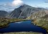
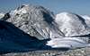
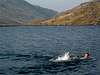
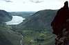
Some views from the mountain
 |  |  |
Tony Simpkins - Mar 25, 2004 3:53 pm - Hasn't voted
Untitled CommentI'm old enough to remember when we had proper winters so to me winter climbing is (or rather was) all about climbing snow and ice, not torquing and scratching my way up summer rock climbs whenever there's a bit of frozen turf. But, given that that seems to be the modern trend then you're perfectly correct - but how often does Engineers Slabs come into condition?
Probemeister - May 10, 2005 12:49 pm - Hasn't voted
Untitled CommentEngineers slabs, and I would imagine most of the other mixed climbs on the N face of great gable was in good condition for at least a month during the last winter.
In addition, lots of the easier mixed routes follow vegetated chimneys, much like lots of mixed climbs in scotland always have done.
That said, the winters have been poorer recently, wish I was a bit older too!
Probemeister - Mar 24, 2004 7:37 am - Hasn't voted
Untitled CommentGreat Gable actually has a large selection of winter mixed climbs on the north face including some of the hardest in the district - see the winter climbing guide for details
Tony Simpkins - Mar 25, 2004 3:53 pm - Hasn't voted
Untitled CommentI'm old enough to remember when we had proper winters so to me winter climbing is (or rather was) all about climbing snow and ice, not torquing and scratching my way up summer rock climbs whenever there's a bit of frozen turf. But, given that that seems to be the modern trend then you're perfectly correct - but how often does Engineers Slabs come into condition?
Probemeister - May 10, 2005 12:49 pm - Hasn't voted
Untitled CommentEngineers slabs, and I would imagine most of the other mixed climbs on the N face of great gable was in good condition for at least a month during the last winter.
In addition, lots of the easier mixed routes follow vegetated chimneys, much like lots of mixed climbs in scotland always have done.
That said, the winters have been poorer recently, wish I was a bit older too!
munroitis - Nov 14, 2006 11:40 pm - Hasn't voted
Remembrance Day serviceTony, You might just want to add a note to reflect the annual remembrance day service held on the summit of Great Gable at 11.00 on the Sunday nearest the 11th November. I attended this last week along with between five hundred and a thousand other walkers. Quite a different experience. Two minutes silence was impecably followed with only the dogs making the odd yap. The service was initally to commemorate the loss of local climbers from teh first world war. Two local landowners gave a chunk of land incorporating GG to the local climbing club as a memorial to lost comrades. Then in 1923 the land opassed to the ownership of the National Trust. I hope this helps. Chris (munroitis)
nks - Dec 9, 2007 3:58 pm - Hasn't voted
New FRCC guide editionNew FRCC guidebook was published this year (2007) for Great Gable and Pillar. Lot's of new photo topos.