
|
|
Mountain/Rock |
|---|---|
|
|
36.55700°N / 118.262°W |
|
|
13770 ft / 4197 m |
|
|
Overview
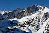
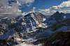
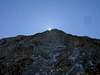
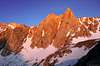
Mt. Irvine is located a quarter mile off the Sierra Crest along a ridge dividing the Mt. Whitney and Meysan Lake Basins, across a small cirque from Mt.Mallory. It is located about two miles southeast of Mt. Whitney in the John Muir Wilderness in Inyo National Forest. Above Meysan Lake rises the impressive, vertical East Buttress, which leads to the summit of Mt. Irvine.Norman Clyde first climbed Mt. Irvine in June 1925, and named this peak and neighboring Mt. Mallory that year in honor of the famous mountaineers who died while climbing Mt. Everest--George Leigh Mallory and Andrew Irvine. Mt. Irvine has outstanding views of Mt. McAdie and one of the best views of the east side of Mt. Whitney. There are several routes up Mt. Irvine: two class 1 routes (the North Slopes and Arc Pass routes (the route Clyde first climbed)); three class 2-3 routes (the East Chute, Traverse from Mallory, and West Face Routes); the class 4 East Couloir; and the East Buttress V, 5.9. It is a good peakbagging doubleheader with nearby Mt. Mallory. See R.J. Secor, The High Sierra: Peaks, Passes, and Trails, or Steve Roper, The Climber’s Guide to the High Sierra, for additional information on routes.
 |  |  |  |
Getting There
The trailhead starts at the Whitney Portal Campground. To reach Whitney Portal, take the Whitney Portal Road west from Lone Pine. There is a turnout at the Meysan Lake trailhead about 0.9 mile east of the road’s end. Park in the turnout near the sign marking the Meysan Lake trailhead. The turnout and sign are on the south side of the road above the east side of the Whitney Portal Campground.Hike across the campground along a series of paved driveways and follow the signs carefully through a summer home area. The trail soon leaves the summer homes and enters the John Muir Wilderness. There are good views of Lone Pine Peak along the trail. At 11,150 feet the trail reaches a flat area near a small tarn and a small creek. From here the route to the Lake is along a ducked use trail. The trail climbs 3600 feet total before reaching Meysan Lake at 11,450 feet.
Red Tape
Unlike permits for hikes in the Mt. Whitney basin, overnight wilderness permits for Meysan Lake are much easier to obtain. However, advanced reservations are still recommended, especially for weekends and holidays, because the trailhead is subject to a use quota. Permits may be reserved for $5/person. Information on wilderness permits is available online. Or, contact Inyo National Forest at (760) 876-6200 for more information. No permit is needed for dayhiking.Climbers approaching from the north via the Mt. Whitney Trail at Bighorn Park need to obtain a Mt. Whitney permit, even for dayhikes. Overnight Whitney entry permits are notoriously difficult to obtain and should, if possible, be reserved several months in advance. They cost $15/person to reserve. There is no fee for permits if they are not reserved in advance.
Do not store any scented items in your car while hiking. Bears commonly break into cars at the Whitney Portal in pursuit of food. Contact Inyo National Forest for more information.
Dogs are allowed in the Meysan Lake area, though this was recently not the case. The current language taken from the FS Webpage is as follows:
Sierra Nevada Bighorn Sheep Habitat
Sierra Nevada Bighorn Sheep Habitat may affect visitors traveling on or near, Taboose, Meysan Lake, Cottonwood Lakes and Tuttle Creek trails, per Forest Order No. 04-02-08, which states: "dogs must be under immediate verbal or physical control of their owners at all times."
So, canines are allowed and it seems that there is no difference from how dogs should be handled by responsible owners on public lands at any other time.
When To Climb
July-October is the best time to climb.Camping
Meysan Lake is a great location to camp, although the short four-mile hike can be arduous because of the 3,600 feet elevation gain. The Whitney Portal campground is also a convenient base camp, although it is often full. You can reserve campsites in advance. Inyo National Forest has online information on campgrounds available. There are also campgrounds located in nearby BLM lands that are often free and less crowded, including Tuttle Creek.Mountain Conditions
Sequoia National Park visitor information: (559) 565-3341Inyo National Forest visitor information: (760) 876-6200
Updated weather information is also available.
tarol - Jul 18, 2006 9:38 pm - Voted 10/10
Wilderness Permit Link is brokenTry this one! http://www.fs.fed.us/r5/inyo/recreation/wild/permitsres.shtml
Noondueler - Apr 14, 2010 8:30 pm - Voted 10/10
Your linkto the "High Sierra Peaks Passes and Trails" on the Mt. Irvine page is inconclusive. -Topocop
Dave K - Apr 14, 2010 10:07 pm - Hasn't voted
Re: Your linkFixed--thanks!