
|
|
Mountain/Rock |
|---|---|
|
|
36.55166°N / 118.27623°W |
|
|
Inyo, Tulare |
|
|
13799 ft / 4206 m |
|
|
Overview
Mt. McAdie is a mountaineer’s summit two miles SSW of Mt. Whitney. The mountain has two prominent summits, the north summit being highest. The standard route is to climb from Arc Pass nearly to the top of the south summit then negotiate a hard class three down climb into the notch between the two summits. A left leading ledge from the notch leads around to the west and up to the north summit.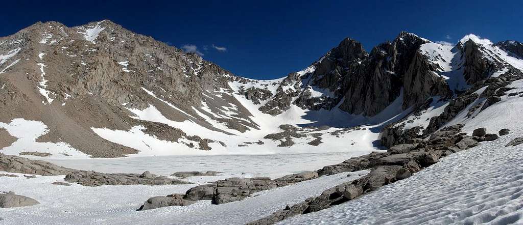

Getting There
Mount McAdie is most easily approached from the Whitney Portal area via the Mount Whitney trail or the Meysan Lake trail. The former is a straightforward route up the popular trail via Consultation Lake, Arc Pass, and finally the summit of Mount McAdie. The significant downside, however, is that the route passes through the Mount Whitney Zone and is subject to both day and overnight quotas and permit restrictions (see Red Tape below). Although the latter option via Meysan Lake involves a 700 descent down to Arc Pass from the Mount Irvine-Mallory ridge, it avoids the Whitney Zone complications and I would definitely recommend it (especially if interested in any of the summits from Mount Irvine to Mount Corcoran).Longer trips are possible and not uncommon using approaches out of Horseshoe Meadows to the south using either the Cottonwood Pass or Cottonwood Lakes (New Army Pass) trails. Miter Basin (just south of Mount McAdie) is exposed, very scenic, and offers access to Mount McAdie via Arc Pass or Crabtree Pass as well as many other peaks surrounding the area.
Whitney Portal/Meysan Lake Trailheads (36.58703° N, 118.23959° W)
Turn west off Highway 395 in Lone Pine onto Whitney Portal Road. Follow the road 12 miles to the extremely large parking area at its end.
If taking the Meysan Lake Trail stop at the signed trailhead pullout on the side of the road near Whitney Portal Campground about three quarters of a mile before the end of the road. Finding the trail beyond the campground can be a little confusing… just cross through the campground and follow the road uphill and back east until the signed trail is encountered.
Horseshoe Meadows Trailhead (36.44775° N, 118.17029° W)
Turn west off Highway 395 in Lone Pine onto Whitney Portal Road. After 3 miles turn left onto Horseshoe Meadows Road. Follow the road south 19 miles to the parking area at its end.
 |
 |
 |
 |
 |
 |
Route Information
 Routes on Middle Summit
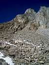
There are three standard approaches based on popularity.
1. Via Arc Pass from the North. Leave the Mt. Whitney trail near Consolation Lake and head south over moraine and talus to the visible saddle.
2. Via Arc Pass from the south. From Sky Blue Lake follow the basin to the northeast. Climb scree to the saddle.
3. Via Crabtree Pass. No matter which way you go, it's a long hike. The climb from Crabtree Pass is easier than from Arc Pass.
From Crabtree Pass climb the obvious chute to the notch between the north and south summits. It's possible to avoid the loose rock by staying on ribs of rock on either side of the chute. Follow the chute to within a few feet of the notch. At this point look for a ledge that leads left around the West Side a bit. This exposed stretch will lead to an obvious route of large broken talus that leads to the summit.
Red Tape
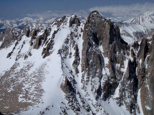 Mount McAdie from the Summit of Mount Irvine
Wilderness Permits:
The approach to Mount McAdie is on Inyo National Forest land (the peak itself is on the boundary with Sequoia National Forest). The approach from the north requires travel through the Mount Whitney Permit Zone, which can be a bit of a pain to deal with even for dayhikes. Other approaches don’t require permits for day trips but overnight trips require one throughout the year. Permits for can be picked up at the Eastern Sierra InterAgency Visitor Center two miles south of Lone Pine. Quotas are in place May 1 through November 1. Check the Inyo National Forest wilderness permit website for the most current information and reservation availability, including additional restrictions if your route takes you through the Mount Whitney Permit Zone.
Food Storage:
Food storage containers are required from Memorial Day to October 31 in the Mount Whitney Zone, Cottonwood Lakes, and Cottonwood Pass areas in Inyo National Forest and the Rock Creek area in Sequoia National Park. Bear lockers are available around Rock Creek at Lower Rock Creek Lake and Lower Soldier Lake (Upper Rock Creek Lake). Proper food storage is permitted without containers on the Meysan Lake trail.
Campfires:
Fires are prohibited throughout the Meysan Lakes trail, the Mount Whitney Zone, and above 10,400 feet within the John Muir Wilderness boundary.
Inyo National Forest Wilderness Permit Office
351 Pacu Lane, Suite 200
Bishop, CA 93514
Wilderness Information Line: (760) 873-2485
Permit Reservation Line: (760) 873-2483
Current Conditions
Current NOAA / National Weather Service ForecastWhen To Climb
Spring through fall is the normal season, however winter ascents and ski tours of Mount McAdie are certainly possible as the approach is quite moderate via Meysan Lake or the Mount Whitney Trail. In winter the road to Whitney Portal has a signed closure at 6500 feet, but it is common practice for cars to continue past the closure until snow is encountered (often nearly all the way to the trailhead). Just don’t get your vehicle stuck during a storm during your ascent!Camping
Mount McAdie is possible as a daytrip, but the area is also popular as an overnight destination. Meysan Lake is an obvious choice if approaching on the Meysan Lake trail, and on the Mount Whitney trail there are several options between Outpost Camp and Consultation Lake. If taking one of the longer approaches out of Horseshow Meadows there are an abundance of locations around Cottonwood Lakes or the scenic and remote basin feeding Rock Creek south of Mount McAdie and Arc and Crabtree Pass. There is a large meadow that makes for a fine location just south of The Miter, and Lower and Upper Rock Creek Lakes (southwest of The Major General) have bear boxes available for use.Dispersed camping is allowed in Inyo National Forest, including a handful of areas along or just off Whitney Portal Road or Horseshoe Meadows Road from Lone Pine.
Established campgrounds are available (and crowded) at Whitney Portal, and several others along Whitney Portal Road, Horseshoe Meadows Road, and at the Horseshow Meadows trailhead. See the Inyo National Forest Campground Camping page for details.
 |
 |
 |
 |
 |
 |