
|
|
Mountain/Rock |
|---|---|
|
|
56.03300°N / 160.38530°E |
|
|
15584 ft / 4750 m |
|
|
Ключевская Сопка
Highest active volcano in Eastern Asia. Sometimes it is defined as the highest active volcano in the whole Euroasia (due to Damavand not significant eruption in last centuries). It is cone shaped volcano, that can be climbed from all sides. Mostly, climbs are from the pass between Klyuchevskaja nad Kamen from the south. Less popular is west route. The height of Klyuchevskaja is in the range from 4750 to 4850 m according to different sources. However, on the north side of the summit crater it is 4750 m.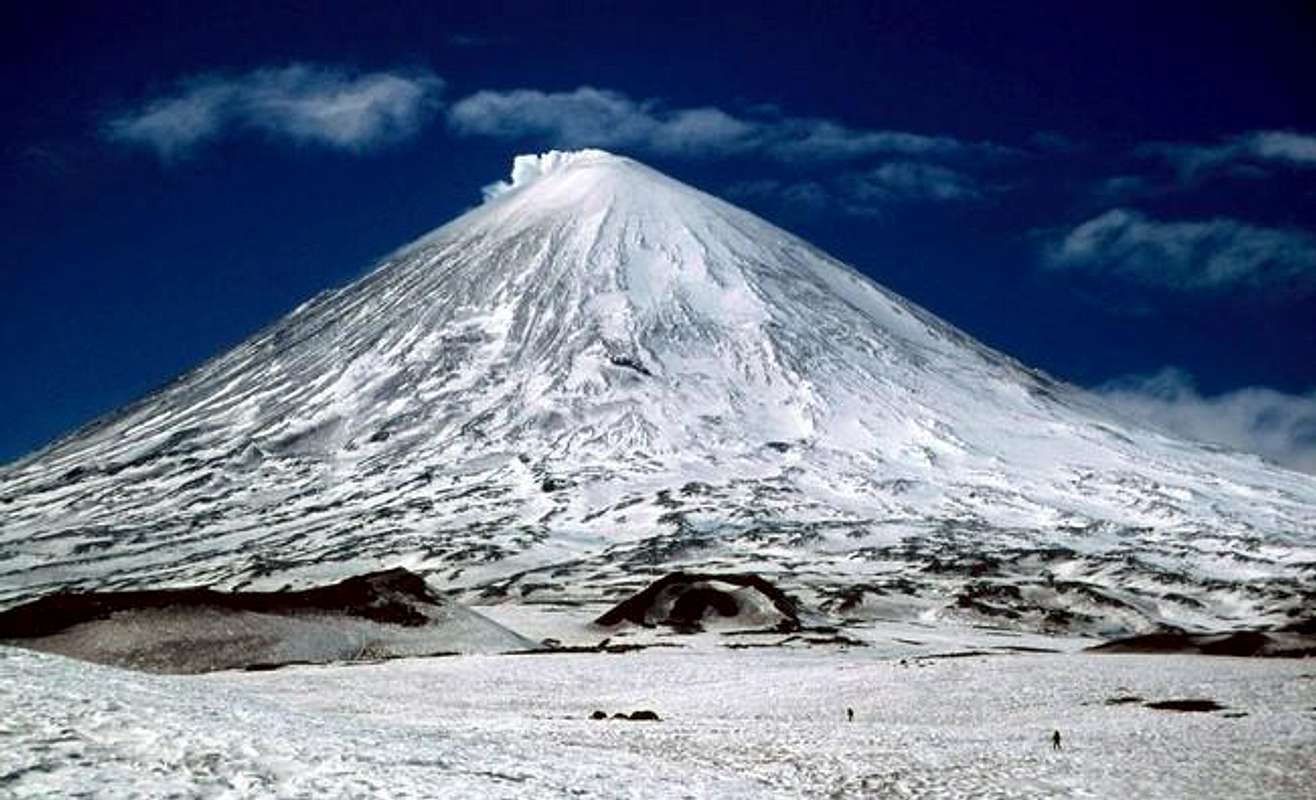
The first ascent of the peak was in 1788 by Daniel Guass and two other members of the Billings Expedition. The second ascent was not until 1931, 143 years later! Several of the members of the 1931 expedition were killed by flying lava bombs on the descent of the peak. Mike Kelsey info - added by Scott Patterson.
 |
 |
 |
 |
 |
Getting There
A flight to Elizovo (the only one international airport at Kamchatka-peninsula), that is about 30 km away from Petropavlovsk-Kamchatskij. You can order an accomodation in Elizovo, or you can move to Petropavlovsk-Kamchatskij or Paratunka. Instead of **, ***, and **** hotels, you can find hostels like accomodation in Severovostok (part of P-K) in "Lyznaja baza Lesnaja", that's the main centre of XC skiing at Kamchatka. Two companies provide bus connection between P-K and Klyuchi several times a week. Tickets are for approximately 600 RUR (Russian rubl) and it is better to buy them in advance. Time for travel is up to 11 hours, and it depends on ferry over the Kamchatka river near Kozyrevsk. More comfortable possibility for a small group is ordering a van (called at Kamchatka "mikrik") for up to 8 persons with equipment. From Klyuchi, it is about 58 km to the altitude approximately 2000 meter on the north side of the Klyuchevskaja's conus. Last possibililty is a helicopter flight from Kozyrevsk - mostly to the base camp on the south side of volcano.
 |
 |
 |
 |
Red Tape
You need valid tourist Russian visa, registration at OVIR for all foreigners within three days after your fly in Kamchatka. Moreover, a special permit for Klyuchi and Klyuchevskaja is necessary as it is border and army zoen. All of it can be managed through several Kamchatka's travel agencies.
It is also possible to order the (required) invitation from http://www.visatorussia.com to get a visa via your local embassy - some travel agents have quite high fees for this job. added by 2hansen
My experience is that it is better to let any Russian travel agent to manage visa, etc. or to ask at your local air-ticket provider for it. Straight from the embassy it could be a trouble. Usual cost for it is about USD 50 + visa.
When To Climb
Klyuchevskaja is accessible over the whole year. However, from autumn to mid spring the weather is mostly really terrible and succesfull climb is just a game of weather. Skiing is recommendable from the end of March to mid May. Better conditions are on the north, as the snow line on the south side is much higher. Surface consist of different kinds of snow, ice, glaciers, and a lot of stones and rocks. On the summit the snow is soft as a result of strong constant volcanic activity. During the summer climbs are easy all over the volcano.
 |
 |
 |
 |
Camping
You can camp where you want - tent, digging bivouac or snow caves. Moreover, there are several volcanologist's huts/bases that can be used. For a pity, most of them are partly of fully destroyed.
The obvious plcae to put up a base camp from S is in the pass between Kamen and Klyuchevskaya. From here it is possible to climb both peaks. Getting to the pass might be a hassle either if you approach from NW or SE. From NW you have to negotiate a huge dirty glacier and from SE it is a long ascend in deep soft snow. Both approaces are beautiful hikes.by JXM
Definately bring a multifuel stove and be prepared to clean it a lot. The fuel obtained in Petropavlovsk is kerosene or diesel, none of them very clean. It is impossible to get gas cannisters at Kamchatka.by JXM
By the way, camping gas canisters can be bought in the outdoor shop "Red-Fox" next to the supermarket "Samsa". Fuel is also OK with stoves like MSR Expedition and MSR Dragoon Fly.
 |
 |
 |
 |
 |
Mountain Conditions
During the summer a helmet is necessity due to the falling of stones and rocks. In summer 2003, one Czech turist was hit to death by stone on the slope of Klyuchevskaja, and several members of rescue team were injured. For winter and spring climbs you need crampoons, ice-axe, avalanche transceiver, snow showel, etc. Helmet is recommendable, but not necessary, as majority of stones and rocks area stabilizated by ice and snow.
Difficulties of the climb are mostly near the summit - strong volcanic activity, gases, temperature, etc. During the climb the worst troubles are falling stones and rocks. We set up our camp on the north at the altitude 2070 m, so that, 2700 altitude meters were for summit day. Usually, the advance camp is set up from the north/north-west at 2700-2900 m. From the south the summit day starts from the pass between Klyuchevskaja and Kamen.
USEFUL LINKS:
Webcam (Remember the time zone is GMT+12!!)
Volcanic Activity Reports
2002 Czechs: Kamchatka 2002
2004 Australians: Kamchatka's telemark/ski-mountaineering expedition
Maps are available at: Map server
 |
 |
 |
 |
BOOKS and JOURNALS
Spravocnik turista, published by RIO-KOT, Petropavlovsk-Kamchatskij 1994, ISBN 5-85857-013-5
Artem Zubkov, Natalia Lapina, Semen Snimayer, Kamchatka 1:0 v polzu poluostrova, journal Vertikalnyj mir No. 18/2000, pp 18-33
Jeremy Schmidt, Carsten Peter, Russia's Frozen Inferno, journal National Geographic, august 2001, pp. 56-73
External Links
- Webcam
View from Klyuchi city (100 m asl), the distance is 30 km north from the volcano.
Institute of Volcanic Geology and Geochemistry, Far East Division, Russian Academy of Sciences.
These digital images are part of an active experimental volcano monitoring project sponsored by IVGG and EMSD with financial assistance from USAID/OFDA. These images are provided to our scientific colleagues as a professional courtesy. Please do not use these images for publication without the permission of Boris Ivanov, Director, IVGG, and Evgenii Gordeev, Director, EMSD. - Activity status reports
The Kamchatkan Volcanic Eruption Response Team (KVERT) is a cooperative program of the Institute for Volcanic Geology and Geochemistry and the Kamchatka Experimental and Methodical Seismological Department in Petropavlovsk-Kamchatsky. KVERT monitors active Kamchatkan volcanoes and provides weekly (or more frequently when activity warrants) status reports and eruption notifications through the Alaska Volcano Observatory. - Kamchatka ski expedition 2002
- 2004 Kamchatka Ski-Mountaineering Expedition
- Skialpinism at Kamchatka 2009 - list of articles, photos and results
JXM - Aug 9, 2004 3:35 pm - Voted 8/10
Untitled CommentDamavand has not erupted in historical times, though occasional steam and sulfur gases exude from the top. The definition of an active volcano is a volcano that is erupting. Also, a volcano that is not presently erupting, but that has erupted within historical time and is considered likely to do so in the future is an active volcano. Damavand is not the highest active volcano in Asia because it is not active.
palic - Aug 6, 2004 5:02 am - Hasn't voted
Untitled CommentKlyuchevskaja sopka is the highest active volcano in eastern Asia. Damavand (5671 m) is the highest active volcano in the whole Asia.
JXM - Aug 9, 2004 3:35 pm - Voted 8/10
Untitled CommentDamavand has not erupted in historical times, though occasional steam and sulfur gases exude from the top. The definition of an active volcano is a volcano that is erupting. Also, a volcano that is not presently erupting, but that has erupted within historical time and is considered likely to do so in the future is an active volcano. Damavand is not the highest active volcano in Asia because it is not active.
Josh - Aug 11, 2004 11:10 am - Hasn't voted
Untitled CommentIt just depends on you definition of active or inactive volcano. By the way, steam and sulfur gases do not exude ocassionally, but constantly. Not only from the top, but also about at the altitude around 5300 m. You can try it :-))) Moreover, check this http://www.skimountaineer.com/ROF/ROF.php?name=Damavand
SiberianSayan - Oct 31, 2005 10:33 pm - Hasn't voted
Untitled CommentThe mountain's name is spelled incorrectly in Russian.
It should be: Êëþ÷åâñêàÿ Ñîïêà -- The second "a" in the first word is missing.
chris_goulet - Feb 22, 2016 1:30 am - Hasn't voted
2013 updatesPropane / butane canisters and other outdoor supplies (but not white gas) are available at: Polaris, 9 Lukashevskogo St., phone: +7 (415)-226-81-00 http://mestarf.ru/petropavlovsk_kamchatskiy/Polaris-1869048.html Where to stay in Klyuchi: Volcanologists’ guesthouse Location: UTM: 57V 0614.836, 6242.936 km. http://volkstat.ru/turizm.html (Russian) https://translate.google.ca/translate?sl=ru&tl=en&js=y&prev=_t&hl=en&ie=UTF-8&u=http%3A%2F%2Fvolkstat.ru%2Fturizm.html&edit-text=&act=url (Google translated to English) The above map server link is dead, but this one has thousands of detailed Soviet topo maps in reasonable resolution from 1:50,000 to 1:1,000,000 scale: http://maps.vlasenko.net/soviet-military-topographic-map/ Klyuchi and Klyuchevskaya: http://maps.vlasenko.net/smtm100/o-57-142.jpg http://maps.vlasenko.net/smtm200/o-57-35.jpg Warning: The datum is Pulkovo 1942. This datum was not in my Garmin Etrex 20. At Klyuchi, the UTM/UPS East-West coordinates are precise enough, but the North-South ones are 2.6km of difference compared to the UTM coordinates on the map grid. This difference does not change on the entire O-57-142 map. For example: at the Klyuchi volcanologists' guesthouse, the GPS reads: 57V 0614.836, 6242.936 km. On the map, this building is at: 27614.8, 6245.5 km. E / W difference:<100m N / S difference: 2.6km 1) Field technique: (used in Kamchatka): Physically go to a location that can be identified on the map. Compare the UTM WGS 84 psn on GPS receiver with UTM coordinates on the map. Calculate correction distances E / W and N / S. 2) Google Earth technique: Pick a point on Google Earth that can be identified on the map. Compare the UTM psn on Google Earth with UTM coordinates on the map. Calculate correction distances E / W and N / S. Once you have the correction distances, add or subtract them to your GPS UTM coordinates to find your position on the map. On the Klyuchevskaya map, add 2.6 km to the N / S coordinates only.
anusk1313 - May 15, 2019 3:12 pm - Voted 10/10
Re: 2013 updatesThank you a lot for the article and the useful information. I'll arrive in Klyuchi in 3 weeks. Is still necessary to buy bus ticket from PK to Klyuchi in advanced? If so, is there any site where I can purchase it online? Thank you!