
|
|
Mountain/Rock |
|---|---|
|
|
55.95000°N / 160.42000°E |
|
|
12080 ft / 3682 m |
|
|
Overview
 Early morning view across the ashfields Early morning view across the ashfields |
 Ashfileds and Tobachik Ashfileds and Tobachik |
 Smaller ash cones around Tolbachik Smaller ash cones around Tolbachik |
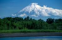 Tolbachik seen from Kamchatka river
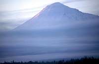 Morning fog on Plosky Tolbachik
Tolbachik actually has two peaks, Ostry Tolbachik (sharp peak) with 3682 m, and Plosky Tolbachik (flat peak) with 3085 m.
A huge (3km diameter) circular collapse caldera is located on the summit of Plosky Tolbachik. Insider this outer caldera there is an inner caldera that measuring 2 km in diameter and up to 150m deep. Plosky Tolbachik erupted most recently from 1967 to 1970 and again from 1975 to 1976. During the last eruption an inner crater formed, which is 400m across and 200m deep.
To the south of the Tolbachiks, there is a huge ashfield with many smaller ash cones. The ashfield was the testing ground for the Russian lunar vehicles. Tolbachik and especially the ashfields with the smaller ash cones are frequently visited by guided tour groups. However, especially Ostry Tolbachik offers many adventurous opportunities for individual climbers.
Tolbachik is in the vicinity of Kliuchevskoy, Kamen and Bezmyianni.
Getting There
 Map of Tolbachik region
Take a public long-distance bus from Petropavlovsk Kamchatskij to the village Kozyrevsk or Kliuchy. Buses leave at the long-distance bus station in Petropavlovsk ('km 10' or 'autostanzia'). If traveling in a larger group, it may be advisory to rent a minivan with driver instead. Kozyrevsk is approx. 600km north of Petropavlovsk, the drive will be a long one. The Kamchatka River is crossed on a small ferry.
In Kozyrevsk, rent a driver to take you up to the Tolbachik ashfield, 4WD necessary. One river (Studsnaya) that has to be crossed on the way to the Tolbachik ashfield may have high water in spring time and it may be impossible to pass. The town Kliuchy is also a possible starting point of access to the Kluchevskoy and Tolbachik group, but Kozyrevsk is closer to Tolbachik.
It is a worthwhile hike or bike ride from Kozyrevsk to the Tolbachiks, if time allows. Be aware that Central Kamchatka is very dry, and drinking water is hard to find on the ashfields around Tolbachik.
 |  |  |  |
Red Tape

A visa for Russia is required, it has to be registered within three days of arrival on Kamchatka. Registration can be done either at OVIR or at some hotels (e.g. Hotel Edelweiss in Petropavlovsk).
Tolbachik is within the Kliuchevskoy Nature Park. Yet, no fees need to be paid and no permit is necessary, but this may change some day. The Kliuchevskoy Nature Park is part of the Volcanoes of Kamchatka - World Heritage List.
When To Climb
 Grass is back on the ashfield Grass is back on the ashfield |
 Ascent over gravel slope Ascent over gravel slope |
 View South. Kronozky volcano in background View South. Kronozky volcano in background |
 Meadows at the foot of Tolbachik
Tolbachik craters and summit can be accessed all year round, however summer months (July, August, September) are best, due to stable weather conditions in Central Kamchatka.
Camping

In the recent years, two basecamps have been established near Tolbachik. One is located on the ashfields and one is at the Studsnaya river where it works its way through the lava. The camps are marked by brightly colored toilet booths.
Apart from that, camping is also possible anywhere else in the alpine tundra, there are many nice spots by the lava strem on the south side of the mountain. Be self-supplied.
Mountain Conditions
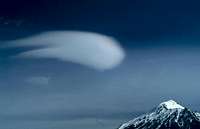 weird lenticular cloud
The Tolbachik region in Central Kamchatka usually has stable weather in the summer months. For climbing Ostry Tolbachik, crampons are recommended, Plosky Tolbachik is more of a hiking peak. Drinking water is hard to find until you have reached the river coming from the Tolbachik glaciers.
 |
Miscellaneous Info
General information about self-organized traveling in Kamchatka can be found here:Kamchatka Website
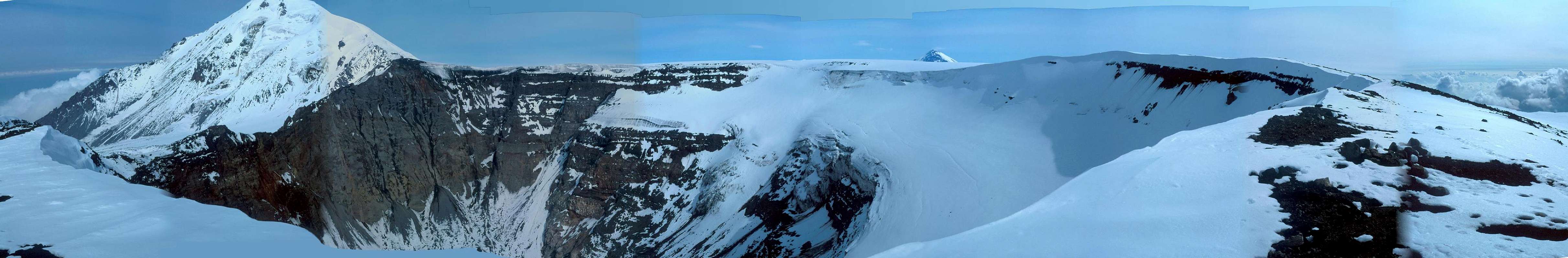
Panorama
  |