
-
 39371 Hits
-
 83.98% Score
-
 21 Votes
|
|
Mountain/Rock |
|---|---|
|
|
43.11940°N / 109.6032°W |
|
|
Mountaineering |
|
|
Summer |
|
|
13517 ft / 4120 m |
|
|
Overview
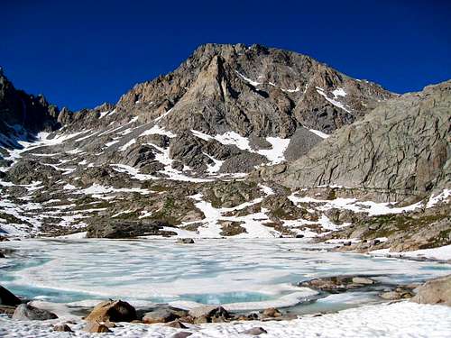
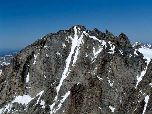
The Wind River Range is a dominant range in the Rockies Mountains. Exceptionally long, wide, high, rugged, and remote, the Winds (as they are known) are little known outside of the hiking and mountaineering communities, but to many they are clearly spectacular mountains. The Wind River Mountains run for 90 miles in a straight line due northwest-southeast in west-central Wyoming. They are only connected to other mountains at their northwest end, and all along their length they rise directly from expansive flatlands. The Continental Divide runs along the entire crest of the range. One of the most striking things about the Winds is their remoteness. No roads cross the range, and in most places the crest is over twenty miles from the nearest trailhead. There are no National Parks or famous landmarks to draw the millions of tourists that go to nearby Yellowstone. Other than a few areas that are popular you are most likely to experience solitude. The closest major towns are Pinedale to the west, Lander and Riverton to the east, and Dubois to the north. Jackson Peak is in the Wind River Range, and is the 8th highest of the 35 Wyoming 13ers (see the list here). It is located between Fremont Peak to the northwest and Indian Pass to the southeast. The mountain is named after William Henry Jackson, a prolific early photographer that captured many early black and white photos of the western US. He is also the one whom Jackson Hole, Wyoming is named after. It is a great peak that has a reasonable standard class 3 route up its southeast ridge. There are some moderate climbing routes up its south face and several ice climbs on its north face.

Getting There
Located in Wyoming's Wind River Range Use the south approach from Pinedale, drive US Highway 191 southbound from Jackson, Wyoming to Pinedale. From Rock Springs, Wyoming on Interstate 80, drive northbound on Highway 191 to Pinedale. At the east end of Pinedale where Highway 191 bears south, (turn at Faler's General Store) proceed east then immediately north on Fremont Lake Road, which soon becomes Forest Road 101. Continue 14.3 miles to a large parking area at the end of the road for the Pole Creek Trail, just beyond the Elkhart Park Ranger Station. From here (Elkhart Park Trailhead), hike the Pole Creek Trail to Island Lake, passing by Photographers Point and Seneca Lake along the way. Just after passing over a small divide at 10,660 feet Island Lake will come into view. Descend to it and continue to the junction with the Titcomb and Indian Basin trails. Take the Indian Basin Trail heading east/rightward and hike to the Indian Lakes where great camping can be had. This all trail approach is somewhere between 15-17 miles long.
Normal Route - SE Ridge Class 3
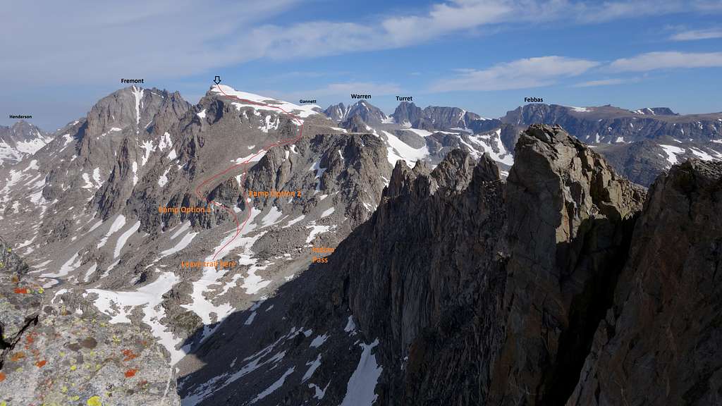
From a camp in Indian Basin, continue hiking up the trail towards Indian Pass, and just before reaching the pass, leave the trail and boulder hop northward, aiming for the obvious weakness in the cliffs guarding the gentle upper SE ridge. There are two main options to reach the easier terrain above, both follow loose ramps up and leftward that will dump you onto the very broad talus slope, which can then be walked north to near the ridgecrest. See the photo below for an overview of these two loose ramp options. Once near the crest, curve to the west and follow the permanent snowfield on the upper part of the flat ridge to the summit. Late in the summer most of this snowfield may be gone, and always excercise caution on the transitions between snow and rock, along the edges of the snowfields. This is because you'll sink to your eyeballs punching through some unknown distance and could even break a leg. Descent is by the same route, and combining this peak with Fremont, or any of the other nearby 13ers makes for a great outing.
Also check out the North Face ice routes, one of which is described well in the linked route page.
When To Climb
Summer season in the Wind Rivers is generally July-September with snow lingering on the higher trails into July. A snow storm is traditional between the last week of August and the second week of September. This is often followed by a dry period with crisp temperatures for 1-4 weeks. On glacier routes crevasses are hidden in June and begin opening sometime in July. As the only high trailhead in the range serviced by a paved road, spring trips from Elkhart Park are common. The road is plowed to within about 2.5 miles of its end in the winter - about 2 miles past the turnoff to White Pine. Wet years, the approach is heavy with mosquitos and gnats in June and July. An area webcam depicts current conditions.
Camping/Red Tape
No red tape; wilderness (leave-no-trace) camping is permitted within the Bridger Wildernesses.
Map
The map above shows the normal SE ridge route up Jackson Peak via the orange line from the Indian/Titcomb Trail junction. The line also shows a big loop I did which encompasses Knife Point mountain, Bete Noire and Fremont. Notice I did one of the ramps heading up, and did the other coming down.
External Links
- http://www.pinedaleonline.com/
Pinedale Wyoming web page for Weather, Local events, business and lodging information. - http://www.crh.noaa.gov/ifps/MapClick.php?CityName=Pinedale&state=WY&site=RIW
National Weather Service Forecast for Pinedale, WY
ActionJackson - Jun 8, 2005 7:19 pm - Hasn't voted
Untitled Commenthttp://www.crh.noaa.gov/riw/nwr/NwrAudio.htm - Added by ActionJackson on June 08, 2005
Click on the Zone Forcast for Riverton/Lander to hear the current forcast for this region. This is the same forecast that is broadcast over your weather radio when in this region.