
-
 15423 Hits
-
 83.1% Score
-
 16 Votes
|
|
Mountain/Rock |
|---|---|
|
|
45.30400°N / 113.728°W |
|
|
Lemhi |
|
|
Hiking, Bouldering, Scrambling |
|
|
10060 ft / 3066 m |
|
|
Overview
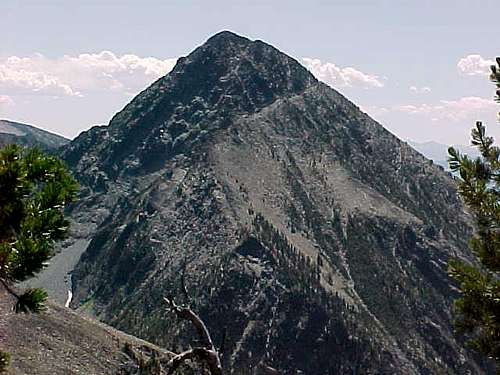
Copperhead Peak at 10060' is located on the northern end of the Beaverhead Mountains just west of the Continental Divide. Copperhead is similar to Freeman Peak in that it is a rugged mountain with more difficult terrain than many of its neighbors.A large cairn sits on Copperhead's summit accompanied by three registers. Most interesting to me was finding a very skillfully carved wooden knife which was carefully laid on a small rock shelf inside the cairn. Easily the most unique item seen to date.
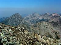
Views of other Beaverhead peaks such as Pyramid, Ajax, Hirschy, Homer Youngs, Freeman, and the Sacajawea Peaks are all visible from the summit of Copperhead.
If it wasn't for the majestic Freeman Peak, Copperhead would qualify as the most dramatic summit seen from the Salmon area.
You will find Copperhead to be a peak worth taking a shot at if you find yourself in the Salmon area.
 Copperhead Peak
Getting There
Take the Carmen Creek Road which is 4 miles north of Salmon on US 93. Travel 5.1 miles on this paved road. At the end of the pavement, turn right onto signed Freeman Creek Road. Travel 3 miles and take a left where the road forks. You will travel 1/2 mile and cross a final cattleguard. Another 1/10 of a mile will bring you to a grassy clearing next to Freeman Creek where you can park. Beyond this, 4WD is advisable for the next 1/2 mile.If you continue to drive up Freeman Creek Road from the grassy clearing, proceed 1/2 mile and take a left which is a 180 degree turn. If you drive this far, you can probably drive to the end of the road. Continue for 1.2 miles to roughly 6600' and take the left fork. I did place a rock cairn here and arrow marking the correct road. From here the single track continues to roughly 6800' into the Golway drainage and eventually ends.
The road directions on page 328 in Idaho A Climbing Guide by Tom Lopez are the same as above and what I used to access the area. The turns were all quite obvious and easy to follow.
Summit Routes
1) Southeast Ridge route Class 3 or 4From the end of the road in the Golway drainage proceed east with the stream being on your left. After a short distance and at a point of your choosing cross the stream and get it on your right (or south side). Proceed up the drainage which eventually curves to the left. Continue to the left and follow this same stream which pours out of a nice open grassy meadow. Your goal is the pond which sits at the far end of the meadow.
 Pond
PondFrom the pond scramble up and gain the southeast ridge immediately. Once on the ridge there are 4 rocky spines that have to be climbed and crossed to proceed. The rock is solid and the holds are good. However, this may be considered Class 4 on a couple of these pitches. Finally, the route opens up and you can pick your way carefully along the south side of the ridge, ascending and descending as needed, through Class 3 terrain to a gully which punches up to within 30' of the summit. A short walk up will put you on top.
Starting elevation from the Freeman Creek parking area: 5730'
Round trip distance: 8.5 to 9 mi. (using a south side descent)
2) South Side ascent route Class 3
 South side ascent route
This route ascends a steep gully guarded by steep rocky ridges on both sides. Though neither glamorous or scenic, it nevertheless avoids the climbing found on the SE ridge.
 South side entry point
Once you have bushwacked across the stream, proceed up the Golway drainage. At 7950' and coordinates 45degrees 17.731N and 113degrees 43.729W, you will have the entry point in front of you. This entry point is not real obvious. However, I picked out the largest boulder I could find and built a rock cairn on it to mark the entry point (see photo). This was my descent route.
The lower sections are filled with vegetation and some wet areas. The upper reaches turn into scree and loose rock. This gully punches all the way up and will leave you about 30' short of the summit. A short walk up will put you on top.
Starting elevation from the Freeman Creek parking area: 5730'
Round trip distance: 7 to 8 mi.
General route notes
 Copperhead's east side
'Idaho A Climbing Guide' by Tom Lopez lists Copperhead as a Class 2. The route contributor may have knowledge of a Class 2 route on the SE ridge that was not apparent to me.
It is possible that a break in the SE ridge further up from where I attacked it might hold an easier ascent. I did not scout it from below. From above it on the ridge line, it curved near the top and you could not see down it. I suspect that it is at least Class 3. At any rate, choose a route that is best for you.
Red Tape
No permits or fees are required. Parking at the grassy clearing next to Freeman Creek is first come, first served. No parking pass required.When To Climb
June, July, August, September are the best months.May and October would depend on snow conditions on the mountain.
 Copperhead's north side
Camping
The grassy parking area next to Freeman Creek would get you the closest access.Public campgrounds:
Tower Rock - 11 mi. north of Salmon on US 93
Twin Creek - 15 mi. north of North Fork on US 93
Shoup Bridge - 5 mi. south of Salmon on US 93
Private campgrounds:
Century II - Salmon
Salmon Meadows - Salmon
Wagonhammer - North Fork
Mountain Conditions
 Copperhead Peak(l) and Ajax Peak(c)
The best choice for road and mountain conditions would be the North Fork Ranger District at 208-865-2700.
I would recommend Norm Ando. Although Norm is the Wild & Scenic River Manager, he has climbed Freeman Peak and can relate to issues that are important to climbers.
Photo credit: thephotohiker.