
-
 8062 Hits
-
 90.81% Score
-
 33 Votes
|
|
Mountain/Rock |
|---|---|
|
|
46.44679°N / 13.81282°E |
|
|
Hiking, Scrambling, Via Ferrata |
|
|
Summer, Fall, Winter |
|
|
7930 ft / 2417 m |
|
|
Overview
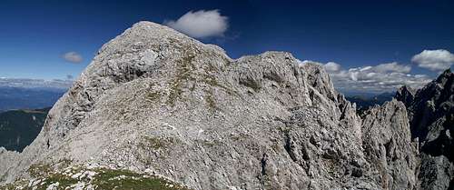 The summit of Lipnica as seen from the exit of the mini ferrata on its south ridge The summit of Lipnica as seen from the exit of the mini ferrata on its south ridge |
Seen for itself the mountain this page is dedicated to surely deserves to be mentioned. At 2417m it stands more than 1600m above its closest trailhead, there are two routes leading to its summit and while both are hiking routes you can't say they are easy. One ends in an exposed scramble across the north-east ridge of our mountain, the other in a short mini-ferrata along its south ridge. The summit offers superb views to the mountains in its vicinity and since it is rather broad it can accommodate a whole busload of climbers. The north and west faces - while not exactly impressive - drop away for several hundred meters while the east face hovers above one of the wildest cirques around.
But - of course - you can't take a mountain out of its surroundings. Lipnica is located in the wildest subgroup of one of the wildest mountain ranges on earth, the Martuljek Group in the Julian Alps. All its neighbours are rough and rocky, but also beautiful peaks and a round topped mountain seems like an anticlimax in this setting. Moreover the real problem of Lipnica (if mountains can have problems) is its neighbour to the north, with which it is connected via a short and exposed ridge. This neighbour, while only 55m higher, is one of the most impressive mountains of the whole mountain range, drawing the attention of thousands of climbers each year. This neighbouring mountain is Spik and the the horizontal distance between the two summits is only 500m. Thus they share the two routes and while many a Spik ascensionist climbs across the Lipnica summit nobody climbs the smaller mountain for itself.
|


It often even gets passed by - the Kacji graben route doesn't touch it and who takes it as both ascent and descent route misses Lipnica altogether. This amounts to a pity because from the summit and both ridges you have gorgeous views towards the mountains around. You might claim that 500m horizontal and 50m vertical distance can't mean that much and that the Spik panorama resembles the Lipnica one. However, there's one thing (or mountain) you can't see from Spik - Spik itself - and from Lipnica it dominates the vista. Moreover the Martuljek mountains are located so close to each other that those 500 horizontal metres change a lot. And last - but not least - by not climbing the Lipnica summit you miss the added excitement of traversing two exposed ridges.
In short: an unobstrusive mountain worth a visit.
Summit Views
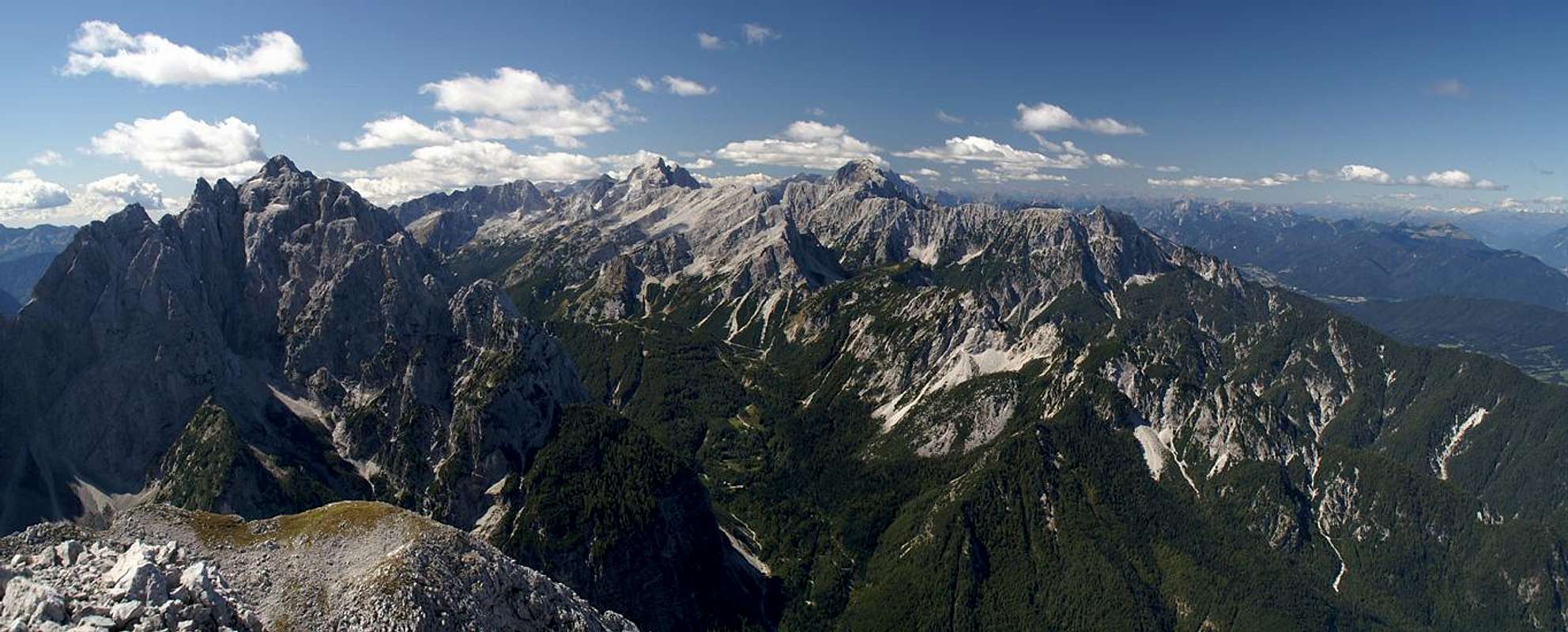  |
Lipnica is a perfect lookout mountain with huge views torwards Velika Ponca, Skrlatica and Spik. To the west across Pisnica Valley you can see the Jalovec / Mangart Group with the Carnic Alps, the Sexten Dolomites and the Hohe Tauern Range in the far background. The summit is a sloped plateau and offers a lot of space.
|


Route Overview
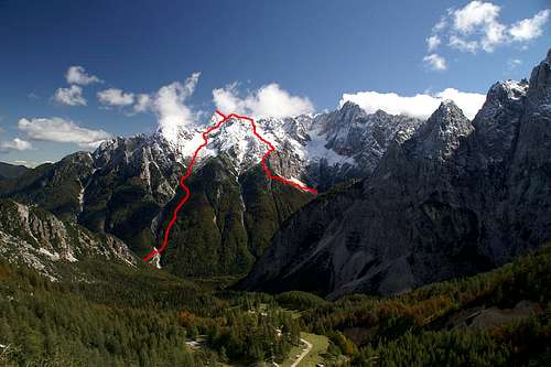 Route overview: Kacji Graben (left), Krnica Route (right)
Summer Routes
- Krnica Route
Long route starting near Kranjska Gora through the Krnica Valley, then ascending to Lipnica from the south-west. The route's crux is the protected section on the south ridge right underneath the Lipnica summit.
- Kacji Graben Route
The shorter of the two routes heading directly up a couloir between Lipnica and Spik. Very steep. Here the crux is the traverse from the base of Spik to the Lipnica summit across the north-east ridge.
Ski Routes
by Vid- Labirint, IV+, details S5 (Lipnica, SE face - Spikova škrbina)
- Lipni graben, IV+, one passage S6.
- Kacji graben, III- , close to where the summer route goes
Getting There
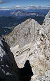
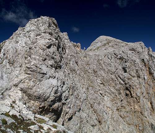 The south ridge mini ferrata to Lipnica (right)
The trailhead for both routes to Spik and Lipnica is located roughly 3km south of Kranjska Gora, Slovenia. The town itself can be found in the north-west of Slovenia - not far away from both the Italian and Austrian borders.
- From Slovenia take motorway A2 to Jessenice, where you switch to 201 to Kranjska Gora,, then on to 206 to Vrsic pass.
From Austria you take motorway A10 through the Karawanken Tunnel, then turn westward on road 201 to Kranjska Gora. In the town turn south onto 206 direction Vrsic Pass. After 3km the road switches from the left bank of the Pisnica River to the right and just before the bridge you can find the trailhead.
- From Italy take motorway A23 to Tarvisio where you turn onto SS54 to Kranjska Gora. Switch to 206 to Vrsic Pass.
Red Tape
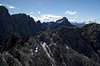
 The Spik south face as seen from Lipnica
Like all mountains of the Slovenian part of the Julian Alps Lipnica and Spik belong to Triglav National Park. I'm not really sure but there appear to be only very few climbing related limitations.
Accommodation
In Sava Valley to the north of the Martuljek Group you can find quite a number of hotel rooms and apartments. The following link directs to the official site of the town of Kranjska Gora:In upper Krnica Valley you can find the hut Koca v Krnici, from which the southern ascent route starts. It is open all summer but closes in early September already.
Weather Conditions
Don't ask me why weatherunderground shows the sticker for Tarvisio when you insert the code for Ratece (5km west of Kranjska Gora) but both towns are very close to each other and they will in all probability have the same weather at all times ;-)
Maps & Books
Both Maps and books should be something our Slovenian SPers know much more about. All guidebooks deal with Spik and thus also cover Lipnica. The following list shows the books I used. Most of them are in German.Books
- Julische Alpen
M. Podhorsky
Rother Verlag
ISBN: 3 7633 4051 3
- Julische Alpen (new edition - completely different)
H. Lang
Rother Verlag
ISBN: 3 7633 4051 3
- Klettersteige Julische Alpen
H. Heindl
Rother Verlag
ISBN: 3 7633 3372 x
- Mountaineering in Slovenia
T. Mihelic
Sidarta
ISBN: 961 6027 36 0
Maps
My map provoked ridicule by the SPers I met in Kranjska Gora so I'm not sure I should recommend it here
- Julische Alpen
Freytag & Berndt Map WK 141
ISBN: 3 85084 735 7
Scale: 1:50000
Vid Pogachnik - Nov 13, 2007 5:07 pm - Voted 10/10
Alpinistic skiingGangolf, you are mentioning the two normal, summer ascents by marked paths. Perhaps you'd make a chapter, named 'Routes Overview' and copy those descriptions there. In addition, for the sake of completeness, you might mention also that from the summit of Lipnica two alpinistic ski tours (hard!) go: 1. Labirint, IV+, details S5 (Lipnica, SE face - Spikova škrbina) 2. Lipni graben, IV+, one passage S6. I guess that skiing by the normal route down in Krnica is also possible, but unattractive - there are rarely good snow conditions on all slopes, and there's a short ferrata section. And secondly, people also do skiing through Kacji graben, which belongs of course to Spik, but can be equally attributed to Lipnica. From Spik, skiing through Kacji graben is rated as an alpinistic ski tour, III- degree, close to where the summer route goes. Cheers! Vid
Gangolf Haub - Nov 14, 2007 2:29 am - Hasn't voted
Re: Alpinistic skiingI will add something - I already though that there might be ski tours. On the other hand I'm very busy at work (!!!) so I don't know when I'll manage to do it.
Gangolf Haub - Nov 14, 2007 3:12 pm - Hasn't voted
Re: Alpinistic skiingI changed the page. I also put up a preliminary route overview picture. Can you indicate where the other two routes run? Is Lipni graben the couloir between the two marked routes?
Gangolf Haub - Nov 14, 2007 3:13 pm - Hasn't voted
Re: Alpinistic skiingOops - I should look at my map before asking silly questions. I fould Lipni graben and I was right.
Vid Pogachnik - Nov 14, 2007 4:15 pm - Voted 10/10
Re: Alpinistic skiingYes, you are right and you did a great job. Thanks! Now let's delete these comments.
Gangolf Haub - Nov 14, 2007 4:39 pm - Hasn't voted
Re: Alpinistic skiingbut do you know where labyrint runs?
Vid Pogachnik - Nov 14, 2007 5:20 pm - Voted 10/10
Re: Alpinistic skiingFrom the description, it's where you wouldn't expect. When you were descending from the summit of Lipnica towards the ferrata section, you should look down towards the left. There's a steep, rugged face towards Ponce and the notch between Spik and Mala Ponca (Spikova skrbina). I would never expect there's a passage for skiing (it must be hard and exposed), so I was never looking down there with the eyes of a skier. But the description is clear.