
-
 20530 Hits
-
 90.13% Score
-
 31 Votes
|
|
Mountain/Rock |
|---|---|
|
|
48.67690°N / 113.6931°W |
|
|
Mountaineering |
|
|
Summer, Fall |
|
|
8016 ft / 2443 m |
|
|
Layout designed for best viewing on a "1024 x 768" screen.

|
|---|
| To visit Glacier National Park is to enter a place where Heaven touches Earth affording brief glimpses into the Wonders of Creation. |
Overview:
Heavy Runner Mountain was named for the Blackfeet Indian Chief, Heavy Runner, who was massacred along with most of his encampment by Major Eugene M. Baker's detachment on the Marias River on January 23, 1870.Heavy Runner was killed as he left his lodge with his gift of an American flag given to him as a promise for his camp's safety.
According to Glacier National Park's "official" historical site...... ”Just prior to the survey of the second section of the international boundary, there occurred a series of incidents that effectively put an end to the Indian troubles east of the mountains and paved the way for a steadily increasing number of exploration parties in the area. Malcolm Clark was one of the early Factors for the fur companies on the Missouri, who later located near Helena and kept a stage station on Prickly Pear Creek. In 1869, some Piegans arrived at the station and asked for Clark. When he appeared at the door, they shot him down and wounded his wife and one son. With the murder of Major Clark, friction arose between the whites and the Piegans, resulting in the so-called "Piegan War" which culminated in the Baker Massacre of 1870. There had been much friction and hard feeling, as well as bloodshed between the two factions for some time. Major Clark's murder, on the one hand, and the cold-blooded killing of Mountain Chief's brother and a young Blood Indian in the streets of Fort Benton, on the other hand, led to open warfare with the Piegans. On January 19, 1870, following numerous Indian raids and agitation for action by Clark's two sons, Horace and Nathan, a column of cavalry and infantry under Brevet Colonel Eugene M. Baker, accompanied by the two Clark boys, left Fort Shaw to find Mountain Chief and his band of some fifteen hundred Blackfeet and settle this trouble once and for all. On the night of January 23, they came upon an Indian village in the dark and surrounded it, presumably thinking it was the camp of Mountain Chief, who was camped farther down the river. The camp was, in reality, a smallpox camp headed by Heavy Runner, an Indian who had been unswervedly friendly to the whites. Heavy Runner went out to meet the men and was shot down. The troops then descended upon the camp and massacred nearly everyone in it, which resulted, from official records, in 173 dead and 20 wounded, nearly all of whom were women and children or men too ill to defend themselves. Some reports state that Baker was informed when the shooting started that this was the wrong camp. Whether it be true or not, the fact remains that it was one of the darkest deeds perpetrated upon the Indians by the white men of this region. The Baker Massacre, horrible though it was, marked the end of organized Indian uprising and opened the way for a period of safer access to the area now included in the park.” Source: Baker Massacre Information |
 |  |
|---|
 |
|---|
Every visitor who travels to Logan Pass will no doubt see Heavy Runner Mountain. With its imposing mass jutting up out over the head of the St. Mary’s Valley Heavy Runner provides a picturesque view driving up the eastside of Going-to-the-Sun Road.
Observing the mountain from Logan Pass puts it in true perspective compared to its neighbors. Heavy Runner is a little over 1,000 feet less in elevation compared to Reynolds Mountain which is connected to its western shoulder. Like Reynolds, Heavy Runner is located approximately 1.5 miles from Logan Pass.
Although it does not possess the commanding presence of its nearest neighbor Heavy Runner Mountain is still a worthy destination for climbers who want to experience a great day in the Logan Pass Area and see some incredible scenery.
Getting There:
 Heavy Runner is located in the middle of this photo behind the horn of Reynolds Mountain as viewed from Cannon
The "Crown of the Continent" is located in northwestern Montana and shares a border with Waterton International Peace Park in Canada. Driving the Going-to-the-Sun Road is the only way to make it to Logan Pass and Heavy Runner Mountain. Typically Logan Pass and Going-to-the-Sun Road opens near the end of June but it can be as early as the middle of June and as late as after July Fourth. The road isn’t open in the winter but you can ski there. Be ready for some gnarly conditions and lots of snow!
Glacier National Park began offering a free Shuttle Service in 2007. This is a great option for exploring the park.
Click here for Road Information regarding conditions, repairs and delay schedules as well as estimated opening dates.
Red Tape:
 Mule Deer in front of Heavy Runner - Reynolds saddle
 Bear Danger!
For current National Park Entrance Fees: Current Park Information
For all the Rules and Regulations governing Glacier National Park look at the Rules and Regulations. You can find a PDF files here with a lengthy treatises about what you can and can't do but it could keep you out of jail.
You do not have to register for day climbs in Glacier National Park but it is recommended. Backcountry travel regulations can be found at Backcountry Travel. There is also information from the Park Service on Mountain Climbing in Glacier.
As with all hiking and climbing in Glacier National Park use caution and practice good manners with the wildlife. You are in bear country. Carry your bear deterrent spray, don’t hike alone and make some noise. For more information please go to the Park's website for Bear Information. The U.S. Forest Service also has helpful information on Grizzly Bear Management.
Routes Overview:
 Heavy Runner Route Topo
GUIDEBOOK:
An up-to-date guidebook for this route can be found in Climb Glacier National Park, Route for Beginning and Intermediate Climbers; Volume 1: Logan Pass, The Garden Wall, and Siyeh Bend. Purchase it when you arrive in northwestern Montana or purchase it on-line at Climb Glacier National Park
There is no climbing route described in J. Gordon Edwards’ A Climber's Guide To Glacier National Park for Heavy Runner Mountain. The mountain has a false summit where the cairn is located after a class 4 cliff and chimney.
A more complicated class 5 climb (Class 5.3) is required for reaching the true summit. Although definitely NOT recommended a good rock climber could do this unroped but a rappel would be highly recommended. Please see the route pages for details regarding climbing and rappel routes on the true summit. There is also a cairn on the True Summit.
Special Considerations:The rock in Glacier Park is widely varied and it is not unusual to find several different types of rock on any given route. Know your rocks and be certain of your safety. J. Gordon Edwards has an excellent section in his guidebook on rock and climbing safety. Be safe and know your limitations as well as those who are climbing with you. Also refer to the following links for further details: GNP Rock and Grading System and the GMS Climbing Guidelines.
Please Note: The Glacier Mountaineering Society along with the NPS established several acceptable approaches to the peaks accessed from Logan Pass. The information desk in the visitor center has a map showing these approaches.
The climbing guide describes numerous approaches to Reynolds Mountain, which would also apply to Heavy Runner Mountain, as all cross country, going directly across the meadows to the mountain. After most of the snow is melted, the NPS closes the meadows and other areas near the pass to protect fragile vegetation.
 Looking down the St. Mary's Valley while on the Heavy Runner via Reynolds Circuit
1) Heavy Runner via Reynolds Circuit, Glacier Park Class 2 & 3 on approach and 4 or 5 on summit attempt
This route completes a circuit around the base of Reynolds Mountain. With incredible views into Hidden Lake, Floral Park, Fusillade Mountain, Eden East (as referred to by George Ostrom of the Over The Hill Gang) and the St. Mary’s Valley as well as spectacular views of Logan Pass and it’s surrounding peaks this route is perhaps the most scenic way to reach the top of Heavy Runner Mountain. Total distance around Reynolds and up to the Heavy Runner Summit is approximately 9 miles and total elevation gained on this route is 2,600 feet.
 The Direct Approach from the Climber's Trail
2) The Direct Approach, Glacier Park Class 2 & 3 in approach and 4 or 5 on summit attempt
For those wishing to not walk around Reynolds the saddle between Heavy Runner and Reynolds can be accessed by dropping down into the valley below the north face of Reynolds via the climber’s trail to Reynold’s from The Hidden Lake Trail. Round trip distance is approximately 7 miles and total elevation gained is about 3,300 feet.
Special Note on a Direct Approach from Logan Pass: A direct approach is generally the way Montanans deal with most obstacles in their path, however in this case the direct approach from Logan Pass Visitors Center is discouraged for a number of reasons. The area around Logan Pass is fragile and can be highly impacted by off trail usage (see Special Considerations). This route would also require increased changes of altitude. There is also a strong possibility of crossing paths with the numerous grizzly bears which are frequently seen from the Visitor’s Center and call this area their home.
When to Climb:
 |  with Reynolds, Bearhat and Clements surrounding Logan Pass.") |  |
|---|
It is possible to climb Heavy Runner as soon as Logan Pass is open. Ideal times to climb are late July to September. Alpinists will experience a higher degree of challenge earlier and later in the season. Logan Pass closes at a moments notice due to poor road conditions and snowfall in October. Plan on additional gear if an early season attempt is made.
Weather:
 This seldom-seen perspective of three well-known GNP peaks is taken from the NW shoulder of Little Chief Mountain. Reynolds is the horn on the left with its nose in the clouds, Heavy Runner Mtn at center, then next on the right is Mount Oberlin; the long ridge continuing right, and out of the picture, is Pollock Mtn, with its summit being just out of the frame. Photo by Vernon, June 4, 2005.
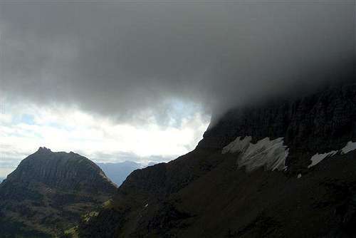 Reynolds shrouded by clouds with view of Heavy Runner in the background
In Montana it is said “If you don't like the weather just wait a half hour” or you can check out what’s up with the local weather at Glacier Park Weather.
Camping:
 No Camping at Logan Pass
Thou shalt not camp at Logan Pass.
The options for camping include: GNP Campground Information, USFS Campgrounds, Camping on the Blackfeet Reservation or East Glacier Campgrounds.
External Links:
Glacier National Park in PicturesGlacier Mountaineering Society
Logan Pass Trails
Visit Montana