
|
|
Mountain/Rock |
|---|---|
|
|
46.20570°N / 115.194°W |
|
|
7623 ft / 2323 m |
|
|
Overview
 East side of Peak 7,623
 Below Jesse Pass
 The summit
 East shelf
Unnamed peak 7,623 is the high point of a large ridge running south from the main body of the Selway Crags, a small local range of the Selway Bitterroots. These highly sculpted jumbles and precipices of Idaho Batholith granite occupy the divide between the Lochsa and Selway canyons in the Clearwater Basin of north central Idaho. At 7,623 feet, this summit is one of the higher points in the group and the highest south of Jesse Pass. It rises nearly 6,000 feet over the lush warm cedar forests of the Selway River in the western end of the extensive Selway Bitterroot Mountains and about 4,000 feet above the forks of Gedney Creek and Canteen Creek, which the extended ridge divides. The immediate ridge top rises about 1,300 feet above Cove Lakes on the west and 1,500 feet above Canteen Meadows to the east. The mile and a half long ridge has other points of 7,569 feet and 7,600 feet, which provide a nice, mostly gentle, subalpine walk at or above treeline. The ridge ties into the main trail south of the pass above Cove Lakes on the south and to Jesse Pass on the north, which allows a nice loop hike with the parallel trail below for those camping at Cove Lakes. It has approximately 403 feet of prominence.
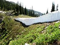
The summit is formed by mounds of jumbled talus blocks on an otherwise broad ridge that is very easy to traverse. The granite dome forming part of the south terminus provides a particularly spectacular site from the Big Fog trailhead about two miles to the south across the deep canyon of Canteen Creek. This face ranges from an open subalpine forest with low shrubs and abundant springs to extensive granite flanks. Around the east side the slopes become more exposed and rugged with vertical walls and seasonal waterfalls below a bench and more gentle slopes above. The bench has an interesting deep, water filled gash in the granite. The west side of the ridge is a mix of subalpine forests and talus while the north aspect forms part of a steep and rugged cirque that drops off into the uppermost Three Links Lake. Snow remains on the cooler, sheltered slopes year round.
The general vicinity is visited heavily primarily because its close proximity to the main east-west trail through this portion of the Crags and the popular Cove Lakes, which sit at the west foot. The actual ridge summit probably is rarely visited, however. Most use would be during hunting season when several outfitters work the area. Wearing orange and traveling in groups is advised during that time. Use is much lighter during mid summer, but the flies and mosquitoes can be hellacious in the lower elevations.
Getting There
 Jesse Pass
 Canteen Basin
 The summit above Jesse Pass
The trailhead most commonly used to access this area is at Big Fog Saddle. To reach this trailhead travel up the Selway River from Highway 12 at Lowell almost to Selway Falls. This is about 18 miles. The first several miles are paved, but most of the road is gravel. Some places are narrow and traffic can be heavy at times so watch the corners. Just before Selway Falls, take a left up the Fog Mountain road (Forest Service road 319). This road is well signed. From the Selway River the trailhead at road’s end is thirteen miles. The first half of this road is narrow, but in fair condition. The second half of the road gets progressively rough with large jutted rocks and seasonal streamlets breaking up the surface. A high clearance vehicle is advisable. The thirteen miles likely will take over an hour.
Once at the trailhead there are two ways to go. The east ridge route is longer, but more scenic and with less vertical change. From the trailhead, this route goes straight up the ridge and over Big Fog Mountain on trail 343. The trail will split with 343 going east and 363 continuing on the main ridge to the north. Soon it will vanish on the broad ridge top but forms again as it peels off the east side of the ridge to on its way to Legend Lake. This trail is spotty and often covered by snow. Avoid the temptation to continue far down the east side on the trail. It is best to stay on the ridge line (or just on the west brim) north. Continue towards the ridge point (7,515) above Legend Lake, then slant down the slope to the northwest toward the saddle above and south of lower Three Links Lake. Here the route cuts west across the north perimeter of the Canteen Creek drainage. Stay on the talus south of the ridgeline to avoid the rugged, impassable crags. When the next saddle, above the upper Three Links Lake is reached, cut up the ridge to the southwest. The ridgeline is most direct, but one can also go more the southwest and over a small ridge hump to the interesting water filled gash that highlights a small hanging basin, then straight up the slope to the ridge high point, unnamed point 7,623.
The other route from the trailhead at Big Fog Saddle takes trail 31 north for approximately six miles to Cove Lakes. This trail drops 540 feet to the bottom of Canteen Creek before climbing 320 feet then dropping another 560 feet to the north fork of Canteen Creek. Then the trail climbs nearly 2,000 feet before dropping a final 800 feet to Cove Lakes. From Cove Lakes the ridge can be climbed to reach the high point. It is best to travel to the northeast to avoid the more steep and dangerous rocks directly above the lakes. The hike from Cove Lakes would take less than a mile and ascend approximately 1,300 feet. Another option from the mosquito infested Cove Lakes is to continue north on trail 31 about a mile before ascending to Jesse Pass on an intermittent trace of a trail. Finding the trail to Jesse Pass is difficult and its probably best to use a topo map to cut up the slope to it. From Jesse Pass hike up the ridge to the south for a short distance to the high point.
Views From the Summit
This is the highest point south of the main east - west axis through the Selway Crags. To the north it offers excellent views of some of the higher peaks and crags in the area, but these features along with the long north running ridge from the highpoint block most distant views in that direction. The view down the Canteen basin is stunning. Again the long ridge blocks much of the view south to the large Selway Canyon. Though several lakes are in close proximity to the mountain, the topography blocks all but the two Cove Lakes. Nonetheless, being on the high point in the southern portion of the area allows one to see miles down the deep basins on the Selway side and for miles beyond towards the Salmon/Clearwater divide.


Red Tape
None, other than standard wilderness regulations.Camping
 East shelf and pond below summit
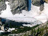 Upper South Three Links Lake
Cove Lakes and Legend Lake are good places to camp to hike this mountain. Cove Lakes are situated almost directly below the high point and Legend Lake, while on the far side of the ridge opposite the basin provides a good place to start the wonderful hike around the upper perimeter of Canteen Creek. An interesting place to camp would be the small subalpine hanging basin immediately below the high point on the east side. This is dominated by a deep, gash in the granite that is filled with water. There is a fair chance of having camping areas to yourself except on weekends. Generally Cove Lakes sees more horses and use while backpackers generally go to Legend Lake.
There are 10 campgrounds and several good dispersed sites along the Selway River road between Highway 12 and Selway Falls for those arriving late who don’t want to navigate the 319 road or arrive at the trailhead in the dark.
When To Climb
The area receives huge amounts of snow and hiking to the summit before late July may be difficult some years. Late summer or early fall would be best, especially after the bugs have died off. However, trips later in the year have the increased likelihood of having the air heavy with smoke from free burning wilderness fires.Mountain Conditions and Information
 East side
 South point
 From above Cove Lakes
Go to the mountain prepared for variable conditions. With over a mile of vertical lift from the canyons of the Lochsa and Selway basins to the top of the Crags, mountain temperatures and weather conditions can vary dramatically. Many years the trails and slopes are open from snow by mid-July, but in heavy snow years some high ground may not lose snow until fall or not at all.
Contact the Moose Creek Ranger District of the Nez Perce National Forest for information and current conditions.
Moose Creek Ranger District/Fenn Ranger Station
831 Selway Road
Kooskia, ID 83539
(208) 926-4258
Office hours
Mon-Fri, 7:30 - 4:00
The north side of the Lochsa/Selway divide is on the Clearwater National Forest, Lochsa Ranger District.
Lochsa Ranger District/Kooskia Ranger Station
Route 1 Box 398
Kooskia, ID 83539
(208) 926-4274
NOAA Forecast