
-
 10711 Hits
-
 88.19% Score
-
 26 Votes
|
|
Mountain/Rock |
|---|---|
|
|
46.76000°N / 12.78000°E |
|
|
8051 ft / 2454 m |
|
|
Overview
Geographical Classification: Eastern Alps > Gailtal Alps > Lienz Dolomites > Kleine Gamswiesenspitze
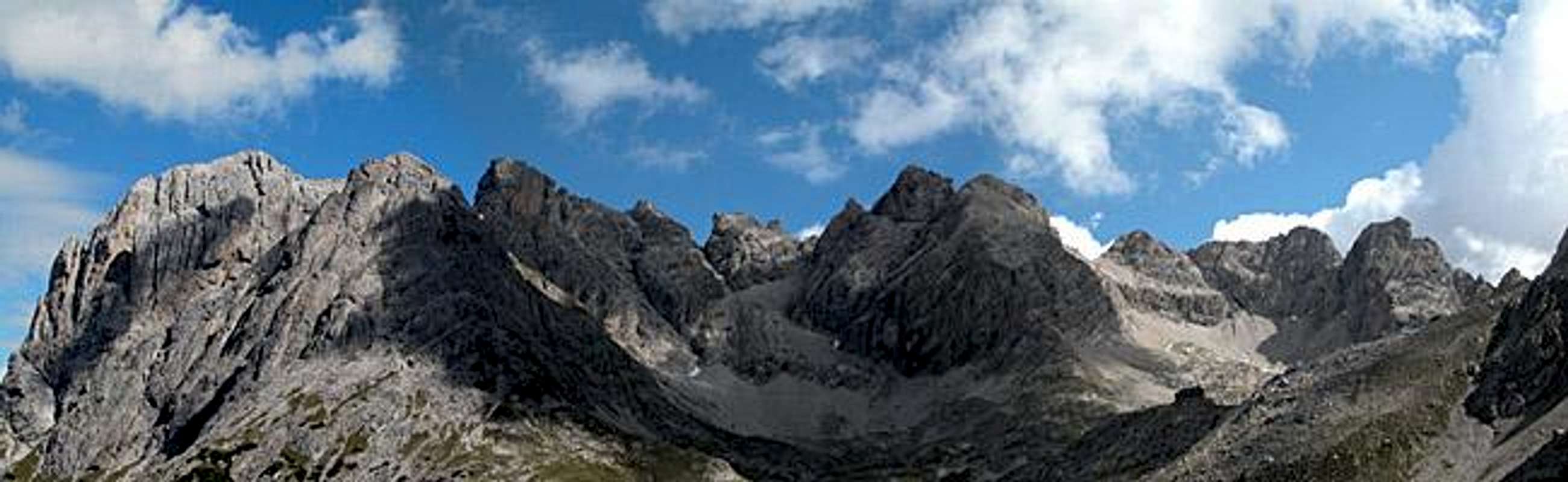
When hiking along the North South Traverse of the Lienz Dolomites we reached the highest point, the Kerschbaumer Törl Pass, none of us would have thought that the tower looming over the pass on its southern side was one of the main climbing destinations of the Lienz Dolomites. Even after the scramble to the top along the marked trail along its southern slope nothing would reveal it. Ok, there might have been a bolt or two but I was too distracted by the great lookout into the heart of the Lienz Dolomites to really see them.
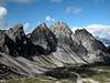
And yes, a great lookout peak it is, Kleine Gamswiesenspitze. It is located at the centre of the Lienz Dolomites mountain range as one of a quadruplet of peaks lined up on the western side of the Laserzbach Valley. It is not the highest one as its name implies - beside Kleine (little) Gamswiesenspitze to the north you can find Grosse (big) Gamswiesenspitze. The other two summits are Kerschbaumer Törlkopf to the south of the quadruplet and Blosskofel to its north.
The central location and its elevation make the peak a good one to look out from (I must have said this somewhere before). To the east you'll find the Laserzgroup with Laserzwand, Roter Turm and Sandspitzen. To the east there are the wide Kerschbaumer Tal and Hallebachtal Valleys which are flanked by Weittalspitze, Kreuzkofel and Spitzkofel. The normal route along the southern flank is rated II while the climbing route has pitches of up to grade IV-.
 |  |  |  |
Climbing Kleine Gamswiesenspitze
While the southern ascent from Kerschbaumer Törl is a steep scramble reaching UIAA II only in a couple of places there is a serious climbing route along the north-eastern edge. It is a 250m, 7 pitch route rated UIAA IV-. You can find infos on the following two pages, both in German with topos:Neighbouring Große Gamswiesenspitze and Bloßkofel can be reached by a ferrata, which is decribed (again in German) here:

Clicking on this topo will take you to www.styria-alpin.at
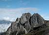
Views from the summit
To prove that the mountain is on of the best lookouts of the Lienz Dolomites here a handful of pictures taken in all directions.
 |  |  |
Getting There
There are two trailheads to the north of the Lienz Dolomites, Lienzer Dolomitenhütte and Klammbrückl. Both are quite near to each other but separated by an elevation difference of 500m The higher and thus easier starting point is Lienzer Dolomitenhütte.From the West (Brenner Motorway A22)
Leave the Brenner Motorway near Brixen / Bressanone and follow SS49 to the east through Pustertal / Val Pusteria. To the east of Innichen / San Candido you cross the Austrian - Italian border and follow the road (now B100) to Burgfrieden. For Klammbrückl turn right (east) here onto a side road, which you follow to its end at the Klammbrückl parking lot. For Lienz and the trailhead at Lienzer Dolomiten Hütte remain on B100 until you reach the city. Here turn right, direction Tristach and cross the Drau River to its southern side. From Tristach the "Dolomitenstrasse" the road into the Lienz Dolomites, is marked by signposts. Follow this road (toll!!) until you reach Lienzer Dolomitenhütte.
From the North
There are two possible roads:
- From Kitzbühel over B108 through the Felbertauern Tunnel to Lienz, then southwest to Burgfrieden and left onto the side road to Klammbrückl (Klammbrückl trailhead) or south to Tristach and "Dolomitenstrasse" as described above (Lienz trailhead)
- From Salzburg along motorway A10 to Spittal. Turn west on B100 to Görtschach, where you turn south towards Lavant and on to Tristach (Lienz trailhead) or go on to Burgfrieden and the sideroad (see above) (Klammbrückl trailhead).
From the South (Udine)
Take Motorway A23 to the exit Camia Tolmezzo. Follow SS52 north to Tolmezzo where you turn onto SS52 bis. This leads to Plöckenpass, where it crosses the Austrian-Italian border. In Austria the road turns into B100 and at Oberdrauburg turn west (still B100) to Görtschach etc.
 |  |  |  |
Red Tape
There's no red tape here. Dogs have to be kept on leash because of grazing sheep but that is about all. Don't camp, rather use the huts (Karlsbader Hütte or Kerschbaumer Schutzhütte) which are an hour away at most.When To Climb
The best time is June through late September. Winter climbs might be possible but you need to be experienced to climb a summit this steep.Accommodation
Free camping in the group is discouraged in the Lienz Dolomites. There are quite a number of refuges all over the Lienz Dolomites (see the Mountain Huts and Refuges Section on the Lienz Dolomites Page) so it should be not neccesary to pitch a tent. If you are looking for hotel rooms or apartments follow one of the links belowWeather Conditions
The Lienz Dolomites are located directly on the border between the two Austrian states Carinthia and East Tyrol, so for a weather report look at one of the pages below:.Maps 'n' Books
MapsI have been using a map by Kompass Verlag, which is very good for the hiking trails though it does not show ALL the relevant summits of the area.
- Lienzer Dolomiten / Lesachtal
1:50000
Kompass Map WK47
Kompass Verlag
ISBN: 3-85491-053-3
Books
Hiking and Trekking
- Osttirol Süd
W. Mair
Rother Verlag
ISBN: 3-7633-4132-3 - German
ISBN: 3-7633-4307-5 - Italian
Good descriptions with maps covering: Defregger Berge, Villgrater Berge, Carnic Alps, Lienz Dolomites
- Gailtal – Lesachtal – Karnischer Höhenweg
Kompass Wanderbuch 982
Kompass Verlag
ISBN: 3-85491-500-4
Good Descriptions with maps and elevation profiles covering: Carnic Alps, Southern Lienz Dolomites, Gailtal Alps
- Mountain Walking in Austria
C. Davies
Cicerone Presss
ISBN: 1852842393
Hiking and trekking in the Austrian Alps (English)