Mt. Langley in a day via Old Army

Mt. Langley in a day via Old Army

Page Type Page Type: Trip Report
Date Date Climbed/Hiked: May 28, 2013
Activities Activities: Mountaineering
Seasons Season: Spring

Mt. Langley in a day

After reading a few other day trip reports of Mt. Langley, myself and 2 others decided to have a go at it and it turned out to be a great decision.  I should note that we rationalized the day trip by seeing car-to-car reports of 12-15 hours and that time frame seemed manageable for us.  We did not read that the round trip mileage tops out at 22 miles until we were driving to the mountain.  I think the prospect of hiking 22miles with a 14ner thrown in there would have turned me away initially and I'm glad I based my decision on the time frame.

Getting There

Horseshoe Meadows Rd. out of Lone Pine is quite steep and I recommend making sure your radiator and brakes are in good working order before you try and summit this in your car.  Also if using Google Maps the Cottonwood Lakes trail head doesn't show up, it's labeled Last Chance Meadow Research Natural Area and just head for the campground on the right.  

We arrived around 9pm and staged our gear for the next day.  We laid out under the stars at 10pm and suffered through 5hrs of pre-hike sleep at elevation.  3am time to do work.

The Hike

Ascent

The trail is very easy to navigate in the dark and having no prior trips out of the trailhead we had no problem finding our way with headlamps.  Maybe it was because it was 3am, dark and we were fresh and excited but I don't remember the first couple miles being downhill.  We flew down this section and started the gradual uphill to the meadow as the sunrise hit us.  I should also mention we were packing double boots, crampons and an ice axe in anticipation of snow/ice on Old Army Pass and this accounted for at least 1/3 of the weight in our packs.  We reached the meadow and were greeted by amazing views of New and Old Army Pass along with Mt. Langley in the distance.
Mt Langley
Reaching the meadow for Cottonwood Lakes May '13
 Also greeting us was a frigid blast of wind that would continue to be the theme of the day.  When we reached the trail split for Muir Lake we made a decision to abandon our boots and crampons because from what we could see (which was not actually Old Army Pass) there was so little snow that we could manage without them, we kept the axes.  Hiking across the meadows we finally laid eyes on Old Army Pass and had began to question our motives to lighten our packs.  However, a few things worked in our favor.  First, Old Army Pass is not as steep as it looks from a distance and if you've spent time talus hiking in the Sierra then you'll have no problems here.  Second, the snow was soft enough for us to cut steps into and maneuver over in hiking boots.  Third, it was too late to turn back and we were motivated.
Old Army Pass
Head right around the lake, then up Old Army pass May '13

Heading right around the last lake before the pass we were able to pick out a few faint trails up the talus slope that led to the prominent bench leading to the top.  We cut steps through the first 2 snow sections and crossed without incident.  The third snow bank we headed straight up which gained us the top of the pass.  The most technical section of the ascent was done, now it's time to drop your head and march.

Cutting Steps
Steep but safe enough May '13
 
Looking towards Langley from top of Old Army Pass
Get ready for the long slog uphill May '13

From the top of Old Army Pass the trail is  exposed and the winds were blowing us sideways.  The soft gravel/sand trail leads upward and crests a few false summits along the way.  At one point the trail dies out and there is a 2/3 class chute to the left that is easy to climb.  From here you can finally see the summit plateau.  We reached the summit in 7hrs 20min.  The summit register was under a large rock with a few rock wind barriers guarding it.  It was so windy at the top we were afraid to stand near the edge because gusts were knocking us around like rag dolls.  15min on the summit and it was time to head down, so long #9 it was a pleasure standing on your summit. 

The summit
Ok, look like you're stoked to be up here! Summit - May '13

Descent

We blazed down the trail, boot skiing the soft sand all the way to the top of Old Army Pass.  Reversing the snow slope was my least favorite part of the day but it was quickly over.  The snow had softened up enough for us to start postholing in the steps we cut earlier making the crossing even safer.  We shortened the descent by glissading a small portion of the pass near the bottom and lets be honest, who can pass up opportunities to glissade.  Back through the meadow and to our lovely boots and crampons, we had made excellent time descending.  At this point we really starting feeling the lack of sleep and exhaustion of the day but we pressed on.  Continuing downhill for a bit with a few stretches of flat we came upon the first section of uphill on our way back.  We knew there was some uphill on the return hike but none of us remember it being a few miles long.  One trip report said their GPS had a total elevation gain of appx 5300' for the day, meaning the return hike has quite a bit of climbing.  I swear I was on a dirt treadmill going uphill.  We made it back to the car in 5hrs 2min.  Car-to-car it took us 12hrs 36min.  Back down the road and into Bishop we were enjoying a victory meal at Whisky Creek by 7pm.

Summary

Don't let the 22 miles scare you away from a day trip.  I had never done that many miles hiking in a day let alone to 14k.  Start early, be on the trail by 4am.  You don't want to be exhausted tired trying to drive down that hill in the dark.  Unless there is still a ton of visible snow in the Sierra you wont need crampons for either New or Old Army Pass BUT I do suggest an ice axe.  And be ready for some fierce winds!  Having summited Mt. Williamson #2, White Mountain #3 and Mount Shasta #5 I can say that Mount Langley is just barely more technical then White Mountain (which is class 1).  Old Army Pass proved to be less technical then the class 2 chute up Williamson, if there had been enough snow there is a direct chute up Old Army that looked similar to the chutes through Red Banks on Shasta.  While not easy, Mt. Langley is definitely technically mellow.

Comments

Post a Comment
Viewing: 1-4 of 4
Diesel

Diesel - Jun 24, 2014 3:26 pm - Voted 10/10

Looks like fun

Thanks for your TR. I plan on hiking up to Langley next week. I searched for newer posts and I found yours. I plan on doing the one day trip and the only one thing that scares me out there is to make a wrong turn and lose day time. I'll print your TR and take it with me on my hike. Keep up with the 14ers. It's a lot of fun. Let me know if you have any other suggestions.

ScottWhitneyBound

ScottWhitneyBound - Jul 3, 2014 12:20 am - Hasn't voted
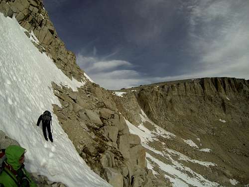
It is a fun hike

I was there on Wed, Jun 25 (one week ago). Your concern about going off course and wasting precious daylight is right on track. I hiked 23 miles roundtrip, but only made it to 13,200 ft (about a mile from the summit) before I decided to head back to the car. I didn't start until 6:15am, which was a mistake; I should have started at least an hour and a half earlier. Mind you, I took New Army Pass, because there was still a lot of snow near the top of Old Army Pass. I have no experience hiking in steep snow, and the only gear I have is hiking poles and microspikes. Even New Army Pass had some snow near the top. It took only about six steps to cross it, but they were some of the scariest steps I've ever taken. By now I'm pretty sure that snow is gone, but Old Army might still require ice axe and crampons. Check here for updates: http://www.nps.gov/seki/planyourvisit/trailcond.htm#CP_JUMP_115630

Also, the route from New Army to Old Army was not at all obvious, so I probably added a 1/2 mile each way in that area, unnecessarily. Once you get to the trail near Old Army, the trail is pretty obvious and marked with several small cairns (some with orange tape) until you summit the penultimate ridge at about 13,000 ft, then you need to find a route to the real summit. When I was there, several rangers were marking the primary route with large cairns (rock piles about 5 feet long), so by now it might be much more obvious than when I tried it. The easiest route from 13,000 ft takes you to the left (west) quite a way around the steep cliff of rocks, but I didn't feel I had time to find it. I plan to try again soon, but I will have more information (would love to have someone's track loaded on my GPS), and will either start earlier or take more than one day, or take Old Army Pass, if it's clear of snow. If Old Army is clear, it should save time vs. New Army. One good plan is to ascend New Army, and then check out Old Army on the way down, and descend that way only if it looks clear.

Good luck!

Diesel

Diesel - Jul 3, 2014 11:14 pm - Voted 10/10

Re: It is a fun hike

I hiked it today! 7/3/14
Went up on Old Army Pass. Summited in 5 1/2 hours. Came down New Army in 5 1/2 hours! 11 hours roundtrip. New Army is looooong. I also stoped and talked to anyone that I met on the trail. There were still rangers building those cairns today. A little snow on Old Army at the top (about 30 steps) but there are good foot steps to use. I had no trekking poles and managed pretty well. My gps said 21 miles roundtrip.

ScottWhitneyBound

ScottWhitneyBound - Jul 21, 2014 11:50 am - Hasn't voted

Re: It is a fun hike

A friend and I did it on Saturday, July 19, 2014. We camped Thursday night at Horseshoe Meadows to get acclimated. Friday we were about 4th in line when the Lone Pine Interagency Visitor Center opened at 8am and the ranger came out and had us draw #16 out of a box (that kinda sucked), but we lucked out and got our free wildernes permits. After an excellent huge breakfast at the Alabama Hills Cafe and a fill-up at the Shell station just north of town, we drove back to Horseshoe Meadows and hiked to High Lake where we camped for the night. We left High Lake at 7:20am Saturday and ascended New Army Pass, summited Langley at 10:10am, descended Old Army Pass, and walked a lovely little-used trail along the east side of Cottonwood Lake #4 to get back to the New Army Pass Trail to High Lake. We spent Saturday night at High Lake again, but it rained quite a bit and at 6:30am Sunday we headed for the car through rain, hail, and lightning, but it was clear about two miles from the car, so we stopped and cooked breakfast before continuing on.

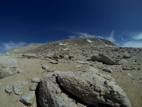
We took what I think is the safest route from about 13,200 ft elevation to the summit of Langley by following the cairns that the rangers have built. The route starts roughly 0.1 mile left of where the trail crests the 13,200-foot high ridge just below Langley. There was only one very short section of class 3 rock climbing at the base of the route (where I turned around on my 1st attempt over 3 weeks earlier), then from then on it was just hiking all the way to the summit, and it took us only 50 minutes.

Old Army Pass had a blockage near the top due to a recent avalanche and still just a bit of snow, so we did a very short section of class 2 climbing on a detour just below the blockage, then back up to the trail. After that it was just a steep narrow zig-zag hike all the way down to Lake #5. Definitely not a good route for those scared of heights.

Viewing: 1-4 of 4