
|
|
Route |
|---|---|
|
|
29.00281°N / 90.23569°E |
|
|
Mountaineering |
|
|
Spring, Fall, Winter |
|
|
Expedition |
|
|
F |
|
|
Overview
 Approach on the frozen Nganyang river
This page is the third route to Unnamed Peak 6161m and Mt. Qunyang (6121m), two obscure twin summits located in the vicinity of Noijin Kangsang (7206m). The South route to Peak 6161m and the Traverse Peak 6161m – Mt Qunyang were climbed during the warmer autumn season, while the present page describes a winter ascent via the Southwest ridge of Mt Qunyang.
Though the approach via the Nganyang valley is the same, the cold and rapid change of weather makes a winter climb a more challenging and totally different experience.
The Southwest ridge is the most direct route to Mt. Qunyang. The ridge itself does not present technical difficulties, though the partly loose scree may be tiring to climb, especially if covered by a layer of fresh snow. Due to its south orientation, the ridge is free of ice, and the glacier starts only on the summit dome.
Getting There
See the main mountain page, getting there section for the approach to the peak via Lhasa or via Shigatse.Route Description
Remark: all the pictures in this page were taken during the winter trip, where bad weather was alternating with clear skies in the mornings. There are therefore only poor quality photos during the climb (and no summit panorama…), but it shows the slightly mystic atmosphere during the climb…The route starts 9km below Karo La at an altitude of 4720m, on the main road between Nagartse and Gyantse. From the turn-off, head north into the Nganyang valley for about 4.5km on a small motorable track until you reach the small Kangbu Lamasery (map P4879m), located near the perched Kangbu glacier lake (5124m).
 1. Nganyang valley 1. Nganyang valley Near the intersection to Noijin Kangsang BC |  2. Above the frozen river 2. Above the frozen river On the way to the camp 5376m |  3. Camp 5376m 3. Camp 5376m With a cold night in perspective… |
From the monastery, follow the Nganyang valley upstream for another 2.5km, until you reach the confluent leading to Naji Kangsha (P5084m on the map). Continue heading north in the main valley for another 2.5km, up to the next confluent (P5241m on the map). You can either camp here (see below the coordinates for camp 5285m), where there is an exceptional view of Noijin Kangsang NE face, as well as Mt. Mengjiu Zhari, or continue upstream for another 1km until you reach camp 5376m (see coordinates below), where Peak 6161m becomes fully visible by clear weather, while Mt Qunyang remains hidden to the north. There is a small unfrozen resurgence near the campsite.
 5. Early morning light on the northeast face of Noijin Kangsang
 Seen from the camp 5376m
 6. Campsite at 5376m 6. Campsite at 5376mWith Unnamed Peak 6161m in the background |  7. Upper Ngangyang valley… 7. Upper Ngangyang valley…With clear weather northwards |  8. Upper Ngangyang valley… 8. Upper Ngangyang valley…With coming clouds southwards |
The valley broadens and offers plenty of additional campsites on the next two km until the small glacier lake at P5650m. Total distance from the turn off on the main road up to P5650m is approximately 12.5km.
Just before you reach the glacier lake, at an altitude of approximately 5600m, Mt Qunyang becomes fully visible to your right (northeast). Head towards the obvious southwest ridge made of more or less loose scree and rocks. The ridge does not present particular technical difficulties, but may become slippery if covered by snow.
Above 6’050m, crampons become necessary as you enter the glacier which covers the summit dome. It was blank ice at the time of climbing (with a thin layer of fresh snow), but the slope is gentle, and the ice axe is almost superfluous.
The summit itself is a wide plateau, from where the panorama by good weather reaches as far as the Tibetan Plateau to the north and the Bhutan border to the south.
 9. Mt Qunyang (6121m) 9. Mt Qunyang (6121m)Altitude approx. 5600m | 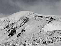 10. Mt Qunyang (6121m) 10. Mt Qunyang (6121m)Southwest ridge |
 11. High on the SW ridge 11. High on the SW ridgeAltitude approx. 6000m |  12. Whiteout on the summit… 12. Whiteout on the summit… |
From the summit, you can either return via the same route, traverse to the summit of Unnamed Peak 6161m, or descend via the foresummit (P6054m) and the south ridge.
Essential Gear
Camping equipment and appropriate clothing for a 6000ers are essentials. In winter, bring sufficient petro/gas for ice melting.Crampons were necessary only on the summit dome. If it is covered by sufficient snow, it might be possible to climb without. Ice axe is recommended but not absolutely necessary. Trekking poles are useful.
GPS waypoints
P5054m: Lat. 28°53'38.00"N Long 90°10'18.00"E Karo La (map 5036m)P4718m: Lat. 28°53'37.00"N Long 90°15'32.00"E Turn off (map 4710m)
P4871m: Lat. 28°55'38.30"N Long 90°14'44.50"E Kangbu Lamasery (map 4879m)
P5285m: Lat. 28°58'22.60"N Long 90°14'13.50"E Campsite (above P5241m, map)
P5376m: Lat. 28°58'48.20"N Long 90°14'18.20"E Campsite (near P5374m, map)
P5362m: Lat. 28°58'49.80"N Long 90°14'13.20"E Spring (unfrozen in winter)
P5650m: Lat. 28°59'42.22"N Long 90°13'31.92"E Possible campsite (near lake)
P5600m: Lat. 28°59'26.94"N Long 90°13'32.28"E Start of the SW ridge (approx.)
P6130m: Lat. 29°00'10.01"N Long 90°14'08.50"E Summit Mt. Qunyang (map 6121m)
Map
 Extract from the NK map, with Peak 6161m and Mt. Qunyang 6121m.
Common approach to the possible campsites in marked in blue
South route to Peak 6161m in red
Traverse Peak 6161 - Mt. Qunyang in yellow
Mt Qunyang Southwest ridge in green