
|
|
Route |
|---|---|
|
|
29.00314°N / 90.21297°E |
|
|
Mountaineering |
|
|
Spring, Fall, Winter |
|
|
Expedition |
|
|
F-PD (high altitude glacier route) |
|
|
Overview
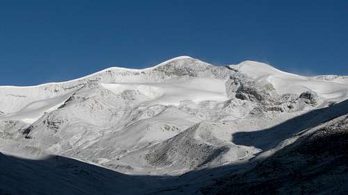 Unnamed Peak 6161m seen from the South
The most logical approach to the Unnamed Peak 6161m is from the South via the Nganyang valley. The South route described in this page is straightforward and offers a nice combination of hiking in its lower part, glacier climb and mixed terrain.
Except the steep loose rocks to access the ridge below the summit, the route is quite safe and does not present important technical difficulty (grade F for the glacier part, PD in the steeper mixed terrain). The route can be climbed all year round, but it is better to avoid the monsoon season (summer) when the whole area is prone to sudden weather change.
This route can represent a good acclimatizing tour before attempting higher peaks in the area, in particular Noijin Kangsang and/or Kaluxung. It can be climbed in one day from Noijin Kangsang Base Camp, but the altitude shouldn’t be underestimated: the summit elevation is only 30m lower than the one of Denali…
Getting There
 P6302m
at the turnoff into the Nganyang valley
See the main mountain page, getting there section for the approach to the peak via Lhasa or via Shigatse.
The route starts 9km below Karo La at an altitude of 4720m.
Route Description
 The last stretch of the route from 5600m to the summit at 6161m.
See the map section below for a full route overview.
From the turn-off, head north into the Nganyang valley for about 4.5km on a small motorable track until you reach the small Kangbu Lamasery (map P4879m), located near the perched Kangbu glacier lake (5124m). The site offers impressive views on Noijin Kangsang east face.
 1. Noijin Kangsang East Face 1. Noijin Kangsang East FaceSeen from P4879m at the end of the motorable track |  2. Kangbu Lamasery 2. Kangbu LamaserySmall monastery located below Kangbu Glacier lake |  3. Himalayan blue sheep 3. Himalayan blue sheepSpotted at around 5’000m in the Nganyang valley |
At the end of the motorable track, follow the Nganyang valley upstream for another 2.5km, until you reach the confluent leading to Naji Kangsha (P5084m on the map). Continue heading north in the main valley for another 2.5km, up to the next confluent (P5241m on the map). You can either camp here (see below the coordinates for camp 5285m), where there is an exceptional view of Noijin Kangsang NE face, as well as Mt. Mengjiu Zhari, or continue upstream for another 1km until you reach camp 5376m (see coordinates below), where Peak 6161m becomes fully visible.
 4. Campsite at 5285m 4. Campsite at 5285mWith Noijin Kangsang NE face in the background |  5. Mengjiu Zhari (6110m) 5. Mengjiu Zhari (6110m)Probably unclimbed (seen from camp 5285m) | 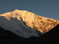 6. Noijin Kangsang (7206m) 6. Noijin Kangsang (7206m) Sunrise on the NE face (seen above camp 5285m) |
The valley broadens and offers plenty of additional campsites on the next two km until the small glacier lake at P5650m. Total distance from the turn off on the main road up to P5650m is approximately 12.5km.
There is plenty of water available from the river (frozen in winter, but you may find some resurgence at a few places), but it is advisable to purify it, as yaks are grazing in the valley during the summer. Wildlife is also quite abundant in the Nganyang valley, and it is not rare to spot large herds of Himalayan Blue Sheep (Pseudois Nayaur).
The real climb starts when you reach the end of the valley, at the bottom of the wide Peak 6161m, which virtually closes the valley.
 7. Peak 6161m 7. Peak 6161m Wide valley above 5400m, with the unnamed Peak 6161m fully visible |  8. Glacier strata at around 5900m 8. Glacier strata at around 5900m The annual accumulation is clearly observable |  9. Noijin Kangsang North Ridge 9. Noijin Kangsang North RidgeSeen from the flat glacier section at around 6000m |
The route I choose was to continue straight to the south, climbing the loose scree until I reached the glacier at an altitude of 5828m. From there, it is a nice climb on a south oriented glacier, which is compact and almost free of crevasses.
At 6’000m (GPS P6001m, see below), a steep section of mixed rock/ice awaits you at the foot of the summit pyramid. I found good conditions in late October, and would grade this section PD only. Depending on the snow/ice cover, it may become a bit more delicate to negotiate.
After 60m of steep climb on the loose rock, you reach a saddle at 6059m. At the saddle, the views on the heavily glaciated northern side of the mountain offer an abrupt contrast with the rather dry south face.
 10. Summit ridge 10. Summit ridge Seen from the saddle at 6059m | 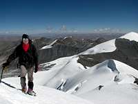 11. Last steps to the summit 11. Last steps to the summit With the traverse ridge on the background |  12. Small summit cornice 12. Small summit cornice With Noijin Kangsang in the background |
From the saddle, it is a straight walk on the ridge to the obvious summit of Unnamed Peak 6161m. The small terminal cornice on the summit did not present any difficulty.
The summit offers excellent views in all directions, from the Bhutan Himalaya (South) to the Nyenchen Tanglha / Nyainqêntanglha range (North).
 13. Summit view: looking SW 13. Summit view: looking SW N-NE ridge leading to Noijin Kangsang (7206m) |  14. Summit view: looking SE 14. Summit view: looking SE Nganyang valley. See the Panorama for a full description of the summits |  15. Summit view: looking N 15. Summit view: looking N Mt. Lungba 6151m, with Qungmoganze / Jomo Gantse (7048m) in the background |
From the summit, you can return via the same route, or make the West-East traverse to the summit of Mt. Qunyang.
Essential Gear
Camping equipment, crampons, ice axe and appropriate clothing for a 6000ers are essentials.GPS Waypoints
GPS waypoints are around 5-20m higher than the altitudes given in the maps.P5054m: Lat. 28°53'38.00"N Long. 90°10'18.00"E Karo La (map 5036m)
P4718m: Lat. 28°53'37.00"N Long 90°15'32.00"E Turn off (map 4710m)
P4871m: Lat. 28°55'38.30"N Long 90°14'44.50"E Kangbu Lamasery (map 4879m)
P5285m: Lat. 28°58'22.60"N Long 90°14'13.50"E Campsite (above P5241m, map)
P5376m: Lat. 28°58'48.20"N Long 90°14'18.20"E Campsite (near P5374m, map)
P5362m: Lat. 28°58'49.80"N Long 90°14'13.20"E Spring (unfrozen in winter)
P5650m: Lat. 28°59'42.22"N Long 90°13'31.92"E Possible campsite (near lake)
P5828m: Lat. 28°59'54.40"N Long 90°13'7.10"E Start of glacier
P6001m: Lat. 29°00'08.50"N Long 90°12'55.90"E Start of steep section
P6059m: Lat. 29°00'11.10"N Long 90°12'57.40"E Saddle
P6161m: Lat. 29°00'11.30"N Long 90°12'46.70"E Summit Unnamed Peak 6161m
Map
 Extract from the NK map, with Peak 6161m and Mt. Qunyang 6121m.
Common approach to the possible campsites in marked in blue
South route to Peak 6161m in red
Traverse Peak 6161 - Mt. Qunyang in yellow
Mt Qunyang Southwest ridge in green