
-
 6292 Hits
-
 81.84% Score
-
 14 Votes
|
|
Area/Range |
|---|---|
|
|
47.49505°N / 10.07930°E |
|
|
Hiking, Skiing |
|
|
Spring, Summer, Fall, Winter |
|
|
6017 ft / 1834 m |
|
|
Overview
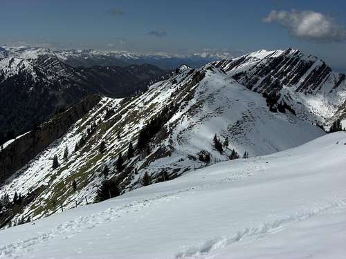
View from Stuiben summit to the west
Nagelfluhkette is a small mountain range within Allgäu Alps. The mountains of Nagelfluhkette are building the northernmost subarea of Allgäu Alps.
The main ridge is a well defined ridge, geographically and geologically clearly separated from the rest of the Allgäu Alps. It culminates at Hochgrat summit, the highest summit of the whole area.
North of it is located a minor ridge (north ridge) with less high summits, the highest of those being Himmeleck and Immenstädter Horn.
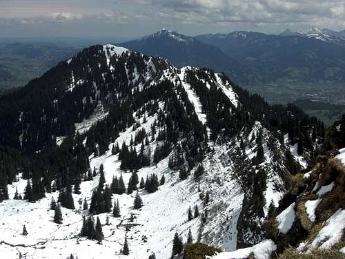
The southern subgroup is also called Hörnergruppe because many of the summits have the suffix “Horn”. The surrounding villages are called “Hörnerdörfer” and a famous ski tour of the region is consequently called “Allgäuer Hörnertour” as most or nearly most of those Hörner can be bagged during this long and nice traverse.
View from Stuiben summit to the east
This small, interesting and beautiful area is bordered to the south by the Gunzesried and Bolgenach valley, to the west by the Hittisau valley, to the north by the valleys of Weißach and Konstanzer Ach creeks and to the east by the Iller valley.
Oberstaufen to the north, Immenstadt and Sonthofen to the east, Balderschwang to the south and Hittisau to the west are the main valley villages of the area.
Thus the main part of Nagelfluhkette and Hörnergruppe is located in Germany / Bavaria, whereas the westernmost part of the area belongs to Austria / Vorarlberg.
The highest summit of Nagelfluhkette is Hochgrat (1834 m; 6017 ft). This summit is located in the middle of the 16 km long, east – west running main ridge. The main ridge has many rock outcrops and therefor has a rather dominant aspect despite of the minor height of the summits, compared to Allgäu Alps main summits.
Nagelfluhkette and Hörnergruppe offer a wide variety of outdoor activities, among them hiking, skiing, ski touring, snow shoe walks, sled routes, paragliding, cross country skiing in the valleys. Two cablecars, Hochgratbahn with adjacent ski lifts, Imbergbahn and ski lifts to Imberg and Mittagbahn to Mittag offer skiing facilities in winter and less altitude difference in spring, summer and autumn when trying to hike along the whole ridge, thus “bagging” 9 summits between Mittagbahn and Hochgratbahn.
Getting There
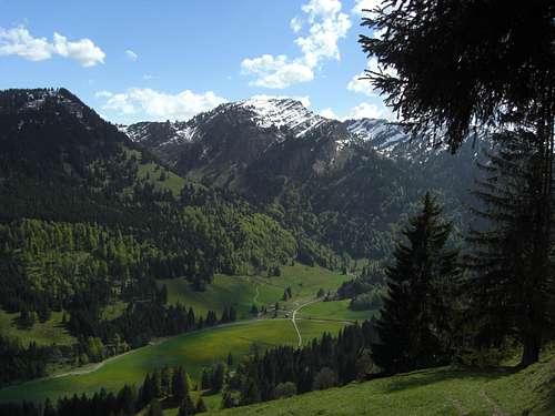
Upper Gunzesried valley with some south range (Hörnergruppe) peaks
The town of Kempten is the entry point to Allgäu Alps.
Use the highway A 7 to Kempten, when coming from north, east or west.
Follow the short highway A 980 and road number B 19 to Immenstadt and Sonthofen.
Northern approach:
Use road number B 308 from Immenstadt to Oberstaufen. To reach Hittisau in Austria, take the road ST 2005 and Austrian road number 205 to the village.
Southern approach:
Use road number OA 27 to the villages of Gunzesried. You can proceed into the valley south of Nagelfluhkette by following Talstraße road to Gunzesried Säge. From there take the toll road Autalweg further into that valley.
Immenstadt, Sonthofen and Oberstaufen do have railway stations.
Check the railroad schedule here
Mountain Ranges & Summits
Area overview:Summit overview:
Nagelfluhkette Main Ridge
| Summit | Country | Height [m/ft] |
|---|---|---|
| Mittagberg or Mittag | D | 1451 m / 4760 ft |
| Bärenköpfle | D | 1463 m / 4799 ft |
| Steineberg | D | 1683 m / 5521 ft |
| Steinköpfle | D | 1669 m / 5475 ft |
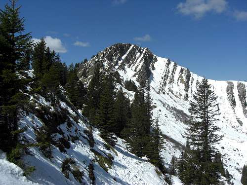
| Stuiben | D | 1749 m / 5738 ft |
| Sederer Stuiben | D | 1737 m / 5698 ft |
| Buralpkopf | D | 1772 m / 5813 ft |
| Gündleskopf | D | 1748 m / 5734 ft |
| Rindalphorn | D | 1822 m / 5977 ft |
| Gelchenwanger Kopf | D | 1805 m / 5921 ft |
| Hochgrat | D | 1834 m / 6017 ft |
| Seelekopf | D | 1663 m / 5456 ft |
| Hohenfluhalpkopf | D | 1636 m / 5367 ft |
| Eineguntkopf or Rohnehöhe | D / A | 1641 m / 5383 ft |
| Falkenköpfe | D / A | 1564 m / 5131 ft |
| Hochhädrich | D / A | 1565 m / 5134 ft |
 Stuiben, Sederer Stuiben from Buralpkopf |  Buralpkopf, Gündleskopf |  Sederer Stuiben, Rindalphorn |
Nagelfluhkette North Ridge
| Summit | Country | Height [m/ft] |
|---|---|---|
| Immenstädter Horn | D | 1480 m / 4855 ft |
| Gschwendner Horn | D | 1430 m / 4691 ft |
| Drehersberg | D | 1420 m / 4658 ft |
| Eckhalde | D | 1490 m / 4888 ft |
| Himmeleck | D | 1487 m / 4878 ft |
| Denneberg | D | 1410 m / 4625 ft |
| Prodel | D | 1375 m / 4511 ft |
| Imberg | D | 1325 m / 4347 ft |
| Fluh | D / A | 1391 m / 4563 ft |
| Kojenstein | D | 1300 m / 4265 ft |
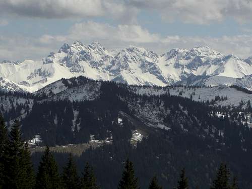
 Steinköpfle |  Part of Hörnergruppe with Allgäu main peaks (background) |  Part of Hörnergruppe |
South Ridge or Hörnergruppe
| Summit | Country | Height [m/ft] |
|---|---|---|
| Koppachstein | A | 1537 m / 5042 ft |
| Stillberg | 1487 m / 4878 ft | |
| Girenkopf | D | 1683 m / 5521 ft |
| Heidenkopf | D | 1685 m / 5528 ft |
| Sipplinger Kopf | D | 1720 m / 5643 ft |
| Tennemooskopf | D | 1628 m / 5341 ft |
| Bleicherhorn | D | 1669 m / 5475 ft |
| Höllritzereck | D | 1669 m / 5475 ft |
| Dreifahnenkopf | D | 1628 m / 4341 ft |
| Grauenstein | D | 1640 m / 5380 ft |
| Riedberger Horn | D | 1792 m / 5879 ft |
| Ochsenkopf | D | 1662 m / 5452 ft |
| Weiherkopf | D | 1665 m / 5462 ft |
| Wannenkopf | D | 1712 m / 5616 ft |
| Bolsterlanger Horn | D | 1588 m / 5209 ft |
| Rangiswanger Horn | D | 1600 m / 5249 ft |
| Sigiswanger Horn | D | 1527 m / 5009 ft |
| Ofterschwanger Horn | D | 1411 m / 4629 ft |
 Stuiben south slopes |  Bleicherhorn, Höllritzereck |
Red Tape
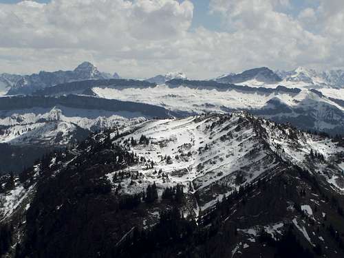
Hoher Ifen, Gotterackerwände and Allgäu main peaks
Nagelfluhkette is part of “Naturpark Nagelfluhkette”.
Naturpark Nagelfluhkette is not exactly a protected National Park.
Nevertheless there are regulations which should be followed and which are indicated at several locations with a variety of restrictions. These are mainly seasonal blocked or regulated access to defined areas. You find these areas on the Alpenverein map, indicated in the "Maps & Guid Books" section below.
These regulations are mainly for the protection of wildlife and wildflowers.
Please respect them, stay on the trails and marked routes or keep out of blocked areas (mainly in winter).
Geology
Nagelfluh (molasse conglomerate) rocks at a col of the main ridge
Nagelfluhkette is a geological interesting area as the rock outcrops are among the youngest deposits involved in the Alpine orogeny.
Nagelfluh means molasses conglomerate and the sedimentation took place in upper tertiary times when erosion processes accumulated debris of the uplifting Alps into the northern foreland trough, called “Molassebecken” (molasses basin).
The youngest sediments surfacing at Nagelfluhkette, called “Untere Süßwassermolasse” (lower terrestrial molasses), were under pressure after their deposit as several 100 meters of upper marine molasses and an upper terrestrial molasses was sedimented on top of lower terrestrial molasses sediments. These conglomerates and interlayered sand- and siltstone layers were baked together and get more or less solid rock.
Stuiben summit north face with typical rock faces and south dipping strata
At the very end of Alpine orogeny this part of the sedimentary basin was involved in orogenetic processes, folded and lifted up. The upper molasses sediments were consequently eroded and the nowadays Nagelfluhkette appeared through the ages.
The not so solid silt- and sandstone layers were easier eroded than the more solid conglomerates. As the whole area was folded up steeply, in some parts nearly perpendicular, the harder conglomerates build nowadays impressive rock faces, rock ridges and huge southward dipping ledges.
Thus geology and erosion formed an impressive and beautiful landscape.
Allgäu inhabitants call the conglomerate of Nagelfluhkette „heavens concrete“ („Herrgottsbeton“).
Accommodation
Towns and villagesThe following towns and villages offer a great variety of accommodation:
Immenstadt
Sonthofen
Gunzesried
Ofterschwang
Balderschwang
Hittisau
Oberstaufen
 Nagelfluhkette is a good lookout for the Allgäu main peaks | 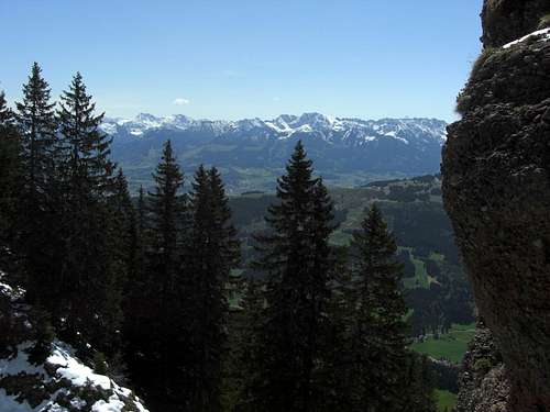 Nice views from Nagelfluhkette to the Allgäu main peaks |
Mountain huts
There are many mountain huts in this area, most of them offer food and drinks for tourists. I will point out only those who are located around the main ridge and offer overnight stays, too.
Kemptener Naturfreundehaus, north of the main ridge
Berghütte Hornklause, near Immenstädte Horn north of the main ridge
Staufner Haus, near Hochgrat, main ridge
Falkenhütte / Allgäu, near Hochhädrich and Falkenköpfe in the western part of the main ridge
Maps & Guide Books
MapsDeutscher Alpenverein: Allgäuer Voralpen West, Nagelfluhkette, Hörnergruppe scale 1 : 25.000, number BY 1, 2012, with trails, ski routes and UTM grid
Landesamt für Vermessung und Geoinformation Bayern: Lindau - Naturpark Nagelfluhkette; scale 1 : 50.000, number UK50-45, 2012, with trails and UTM grid
Freytag-Berndt und ARTARIA: Bregenzerwald, Wanderkarte, scale 1:50.000, number WK 364, with trails and bike routes; this map covers only the western parts of Nagelfluhkette!!
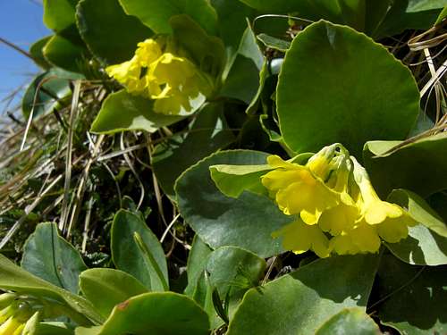 Primula auricula near Buralpkopf summit | 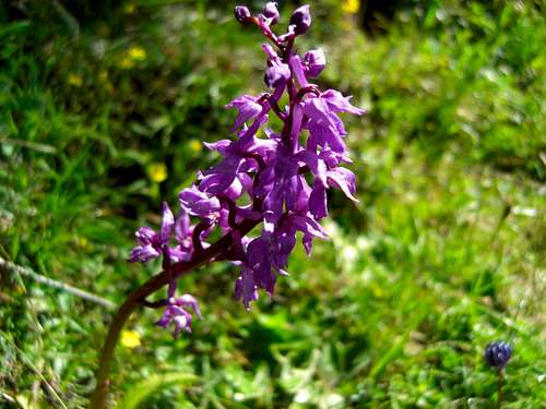 South side wildflower |
Guide Books
Dieter Seibert: Allgäuer Alpen und Ammergauer Alpen, alpin; Bergverlag Rudolf Rother, München, 13th edition, 2013
Dieter Seibert, Heinz Groth: Allgäuer Alpen, Gebietsführer für Wanderer und Bergsteiger; Bergverlag Rudolf Rother, München, 9th edition, 1999 – actually out of stock but available as antiquarian book
Dieter Seibert: Allgäu 3, Oberstaufemn und Westallgäu; Rother Wanderführer, München, 6th edition, 2014