
-
 3785 Hits
-
 80.49% Score
-
 12 Votes
|
|
Mountain/Rock |
|---|---|
|
|
47.44848°N / 10.19272°E |
|
|
Hiking, Skiing |
|
|
Spring, Summer, Fall, Winter |
|
|
5617 ft / 1712 m |
|
|
Overview
 Wannenkopf seen during the traverse from Riedberger Horn Wannenkopf seen during the traverse from Riedberger Horn |
Wannenkopf is the third highest summit of Hörnergruppe (also Hörner), one of the two prealpine subgroups of the Allgäu Alps east of the Iller River (the other one is Nagelfluhkette in the north). It is located east of the Grasgehren ski area - a wide pasture in summer - and stands about 900m above the village of Obermaiselstein. It is a typical summit for the subgroup, a round-topped grass covered mountain which is still beneath the timberline so that trees reach up to the top.
The area is a popular hiking ground from Spring through autumn with lots of panoramic hiking trails criss-crossing and traversing the ridges. Very interesting is the traverse Wannenkopf - Riedberger Horn - Dreifahnenkopf - Hölleritzer Eck, most of which offers wonderful views towards the higher Allgäu mountains to the east and south. Together with a possible return route via Großer Ochsenkopf it is one of the grand hiking routes of the range.
 |  |  |
Wannenkopf itself is considered one of the least interesting mountains of the traverse, mainly because of the vegetation on its summit. There are no views towards the north and west, but to the east and south you can see the Daumen Group and a good part of the Allgäu Alps Main Ridge. While most of the hike to Wannenkopf is easy the last 50m are a steep scramble across grass covered slopes, which can be slippery in wet conditions.
Though not part of any recommended ski or snowshoe tour, Wannenkopf nevertheless is quite often visited in winter. Most visitors use the Grasgehren ski lifts to get to the summit ridge from where the final ascent is little more than a short almost level stroll. A more serious route follows the normal route to Riedberger Horn to the saddle between the two mountains and then follows the broad ridge.
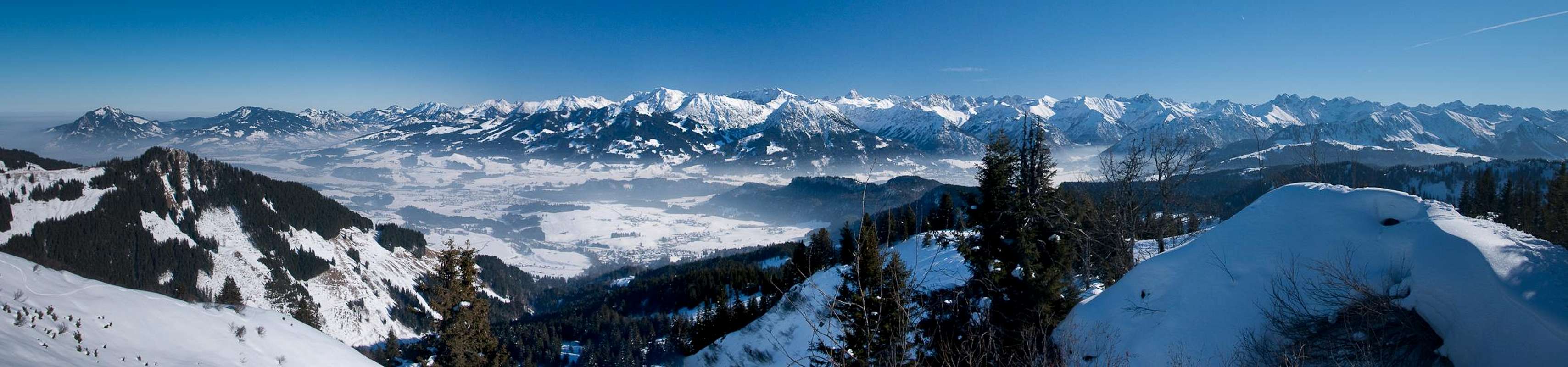
Summit Panorama
  |
Getting There
 Wannenkopf in front of the Daumen Group as seen from Riedberger Horn
There are three trailheads for Wannenkopf, one at Grasgehren near Riedbergpass, the other from the cable-car at Bolsterlang the third in the village of Obermaiselstein. Both can be reached from the Iller Valey in the Allgäu Alps. The closest airports are at Stuttgart and Munich, both cities being connected by motorway A8.
- Take motorway A8 to the intersection Kreuz Ulm-Elchingen.
- Turn onto motorway A7 south, direction Kempten and Füssen.
- At the intersection Dreieck Allgäu switch to A980.
- A few km later turn onto B19, direction Oberstdorf.
- At Fischen turn onto OA9 to Obermaiselstein.
- For the cable-car "Hörnerbahn" follow the signs to Bolsterlang
- For Riedbergpass stay on OA9.
- In the saddle turn right into Grasgehren.
Red Tape
Wannenkopf stands above the ski area of Grasgehren and there are very few restrictions. In winter stay clear of the ski runs, in summer also keep to the paths and tracks as the area is used for cattle grazing.The valleys to the north and south of Wannenkopf have been declared "Ruhegebiet" (sanctuary) in winter.
Accommodation
You can choose between campgrounds, farm holidays, vacation homes and hotel rooms on most of the sites of the Allgäu villages. Good starting points for your search are:Weather Conditions
Maps & Books
Maps
- Allgäuer Alpen / Kleinwalsertal
1:50000
Kompass Map WK 3
Kompass Verlag
ISBN: 3-85491-005-3
- Alpenvereinskarten : Allgäu-West
1:25000
Deutscher Alpenverein
ISBN: 3928777130
Books
- Allgäuer Alpen und Ammergauer Alpen Alpin
D. Seibert
Alpenvereinsführer
Rother Verlag
ISBN: 3-7633-1126-2
- Allgäu 1 - Oberallgäu und Kleinwalsertal
D. Seibert
Rother Verlag
ISBN: 3-7633-4289-3