|
|
Route |
|---|---|
|
|
39.81080°N / 111.7644°W |
|
|
Basic Snow/Hike |
|
|
Most of a day |
|
|
Class 1-3 |
|
|
Approach
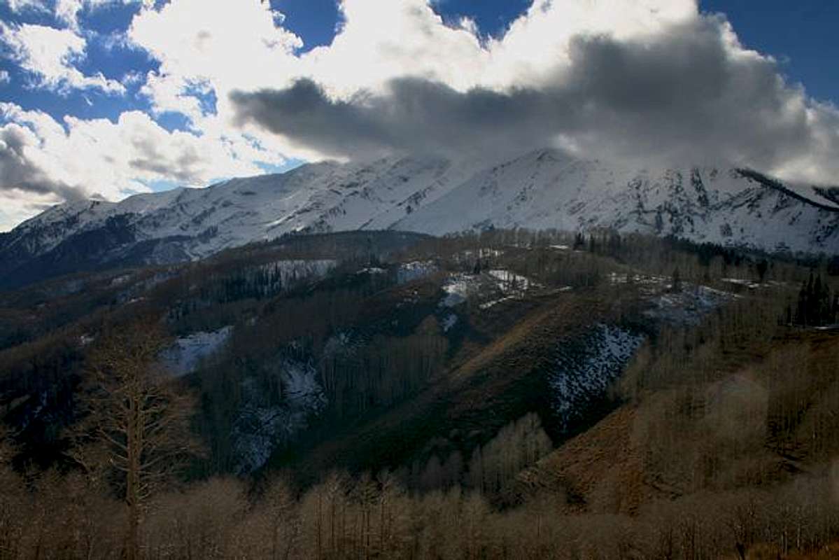
The Nebo Bench route, for Mt. Nebo, follows the same goal as the North Ridge route: reach Wolf Pass and follow the north ridge to the summit. I believe the Nebo Bench route is worth mentioning because its east-facing terrain harbors snow earlier and longer than the west-facing terrain of the North Ridge route. The snow adds an exciting component to a classic Wasatch mountain.
NOTICE: If you are familiar with Mt. Nebo summer terrain, remember that everything changes with snow cover. If you choose this route for an abundance of early fall or late spring snow, BE CAREFUL. This east face terrain is ripe with serious avalanche danger and is a dangerous aspect in the Wasatch. There are no islands of safety anywhere from the base of North Peak's east face to Wolf Pass. Once you are on Nebo's north ridge, one slip will send you a thousand feet down. Know what you are doing if you decide to travel this route in late fall, winter, or late spring.
These are the same instructions provided on the main Mt. Nebo page:
"The North Approach:
Take Interstate 15 south from Salt Lake City for about 40 miles to the town of Payson. Take the Payson exit and measure from here. The trailhead is exactly 25 miles from the Interstate 15 exit. Go through the town of Payson for 0.7 miles and turn left at a light (100 N). Signs point the way to the Nebo Scenic Byway. Turn right after 0.2 miles onto the Nebo Scenic Byway and continue 24 miles to the Nebo Bench Trail." --rmjwinters
The parking lot that identifies the Nebo Bench Trail has a large forest service sign at the turnoff that reads "Monument Trailhead." Why? Who knows. But from this parking lot there are two trails that lead to the Nebo Bench route.
1. On the south end of the parking lot there are a few information boards, an outhouse, and a sign marking the beginning of the Nebo Bench Trail. This trail is designated on basic topo maps. The trail leads downhill through a large gully, then recovers on an uphill section that leads to the base of the east face of North Peak. The trail loses, then gains, roughly 300 vertical feet through the gully.
2. On the north end of the parking lot is a jeep road (Mona Pole Rd.) that leads .3 miles to another trailhead. This is the trailhead described in the North Ridge route for Mt. Nebo. This trail leads around the west face of North Peak, but also has a branch (which is designated on basic topo maps) that meets up with the previous Nebo Bench Trail and follows the base of the east face of North Peak. The benefit of this alternative is that you skip the downhill section of the Nebo Bench Trail (you will greatly appreciate that choice on the return!).
 |  |  |  |  |
Route Description
Regardless of the trailhead you choose, they both lead to the same goal: traversing the base of North Peak's east face toward Nebo's Wolf Pass.
Hiking along the Nebo Bench Trail, under the east face of North Peak, is astoundingly scenic--especially in the morning light. Views of Mt. Nebo are powerful from this perspective, and even better are the numerous gullies and drainages that lead east, away from the mountain. They are steep, deep, and wildlife abounds. If you are lucky, an early morning can treat you with clouds and fog lifting out of these drainages at sunrise.
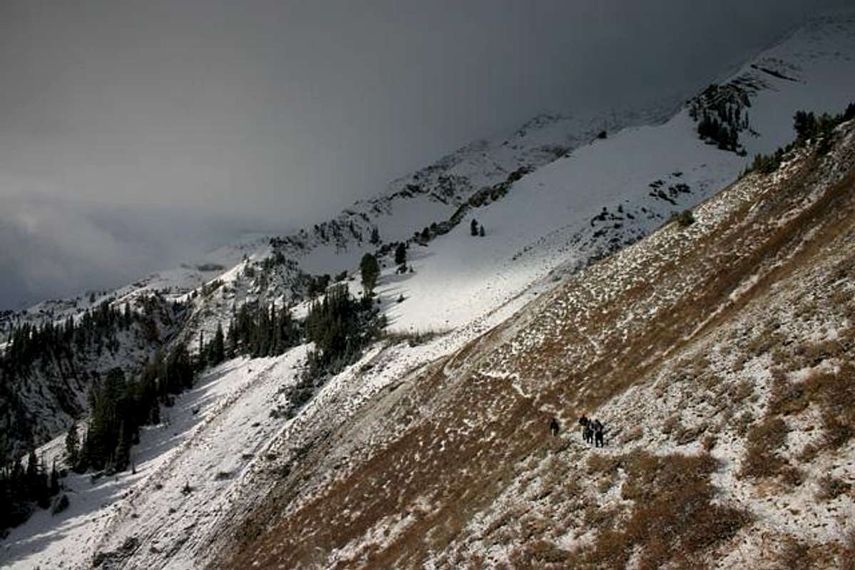
As you traverse south on the Nebo Bench Trail, you will reach Mt. Nebo's territory. There are three massive ridges leading to the summit ridge that you can see. The closest ridge leads to Nebo's north shoulder. Just north of this ridge is a large bowl that climbs to Wolf Pass (the separation between Mt. Nebo and North Peak). This large bowl funnels into a steep gully that crosses the Nebo Bench Trail. Leave the trail and head up the gully. This terrain goes from Class 1 to Class 2.
The steep gully will eventually open up into the bowl beneath Wolf Pass. The route from here is obvious. Your goal is reaching Wolf Pass. The upper section of the bowl averages 33 degrees with a max of 37. Steeper lines abound if you want more of a challenge.
Once on top of Wolf Pass, turn south and follow the ridge up to the north shoulder, then the summit. The terrain is technically Class 2, but can crossover into Class 3 because of exposure. Beginners will find this ridge intimidating, but the experienced hiker/climber probably won't think twice.
NOTICE: Of course everything changes with snow cover. If you choose this route for an abundance of early fall or late spring snow, BE CAREFUL. This east face terrain is ripe with serious avalanche danger and is a dangerous aspect in the Wasatch. There are no islands of safety anywhere from the base of North Peak's east face to Wolf Pass. Once you are on Nebo's north ridge, one slip will send you a thousand feet down. Know what you are doing if you decide to travel this route in late fall, winter, or late spring.
 |  |  |  |  |
Essential Gear
Summer: normal hiking stuff, lots of water, sunscreen and a hat (no shade on this baby).
Winter (or anytime with snow cover): axe/crampons and avalanche gear.
 |  |  |
Miscellaneous Info
If you have information about this route that doesn't pertain to any of the other sections, please add it here.