|
|
Route |
|---|---|
|
|
39.82172°N / 111.7598°W |
|
|
Mountaineering |
|
|
Spring, Winter |
|
|
A long day |
|
|
mostly 40-45 degrees, section of 60+ at the top |
|
|
Overview
The North Coulior consist of the Northwest Coulior and Champagne Couloir. Both couloirs originate just below the summit of Mount Nebo and provide fun terrain for ski descents or spring/summer ascents. During winter and spring months, these couloirs are major avalanche paths so exercise proper caution and only travel with the proper avalanche gear and knowledge.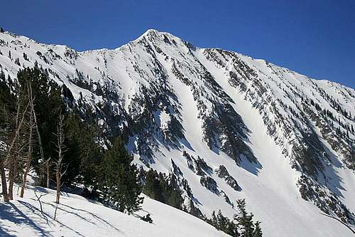
Champagne and Northwest Couloirs.
Champagne and Northwest Couloirs.
Getting There

Map

Avalanche path to go up Pole Canyon Basin.

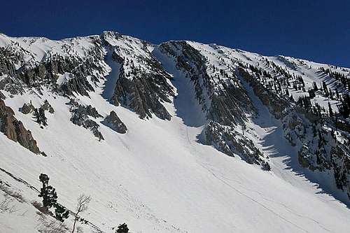
Looking down Champagne Couloir.

Steep snow from Champagne Coulior to the summit.

Looking down Northwest Couloir.

Ridge from NW couloir to the summit.
At the mouth of Pole Canyon there is a large Forest Service sign showing a general map of the Mona Pole Road, which is that dirt road that you will be driving. From here the road is rough. It doesn't have a lot of ruts, but rather lots of large rocks all over. A regular car won't make it very far. A truck or other 4x4 vehicle should be fine as long as you have good clearance. In late April, we were able to drive to about 7,000 feet. Snow and felled trees stopped us. With an ATV you could get much higher. In the summer, the road is cleared of all debris and you can drive the whole thing.
Route Description
The route description will start from 7,000 feet on the Mona Pole Road where we parked our car.Continue hiking up the road until to reach a large avalanche path that crosses the road just above 7,800 feet. This avalanche path is on the south (right) side of the road. Travel up the avalanche path and trend south into the main Pole Canyon Basin drainage. Continue up the drainage finding the path of least resistance until you are in the main Pole Canyon Basin. This basin is an enormous bowl with clear visibility of the path to the summit. Continue up the basin (about 25 degree angle) to the base of the North Couloirs. The couloir on the right (west) is Northwest Couloir. The couloir on the left (east) is Champagne Couloir.
Northwest Couloir
This is the large, wide couloir on the right (west). It starts about 30 degrees, and gradually increases to a sustained 40-45 degrees. The top 100 feet pushes past 60 degrees, with a short vertical section to climb around the cornice at the top. When we did it there was a safe vertical section of the headwall just left of the hanging cornice. The couloir ends about 100 feet short of the summit. Climb class 2-3 rock to the top.
Champagne Couloir
This is the narrow couloir on the left (east). It starts at about 35 degrees, and gradually increases to a sustained 45 degrees. There is a short section of 50 degrees two-thirds of the way up the couloir. There is no cornice that forms at the top. The couloir ends on the north ridge, about 100 feet from the summit. On the north ridge there is a 60-foot section of 58-degree snow. A bit more walking after that and you're at the summit.
To descend, just glissade the couloirs. It's a blast! Another option is to bring skis and ski the couloirs. That's what we did. The snow in late April is still too soft and powdery in the couloirs for spring climbing, so we climbed the north ridge from the Jones Hollow route and skied down the couliors. The spring snow in these couliors is most likely best for crampons from mid-May to late-June.
Essential Gear
Skis or snowshoes to ascend up to the couliors. Crampons/axe/helmet in the couloirs.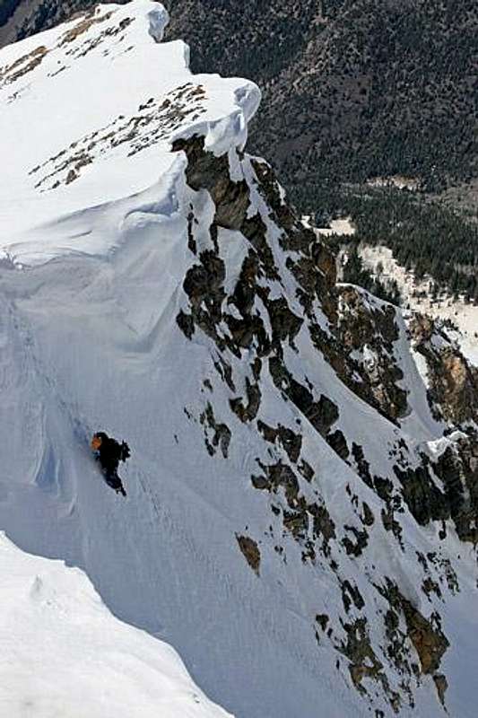
Top of Northwest Couloir.
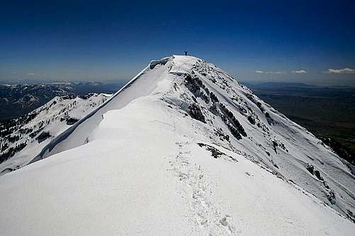
Summit of Mount Nebo.
seano - Apr 30, 2013 6:27 pm - Hasn't voted
Slightly confusingYou write "This avalanche path originates on the left (north) side of Pole Canyon Basin..." I think you're right, but this can be a bit confusing. The road does not go up Pole Canyon Basin, but continues east and north up the main valley. So while the avy path is on the north (NE) side of PCB, it is actually (as expected) on the south side of the road.
marauders - May 7, 2013 2:24 pm - Hasn't voted
Re: Slightly confusingI made the change. Thanks for the input.