Stats of Trip up Mount Aix
Mount Aix
ELevation: 7766 feet
Vertical Gain: 4200 feet
YDS Class: Scramble is a YDS Class 2; The rest is a walk up
Distance: 10.8 milesNo Aches on Aix!!
Boy looking outside this morning it sure looked bad out in Seattle. What a nasty downpour this morning. It did not look good, but Aix isn’t anywhere near Seattle. In fact it is in a rain shadow. Let's see how good this rain shadow is!
This trip involved people from NWHikers.net and included Fran, her boyfriend Todd, Jason, John and yours truly EastKing. On the way up it was just looking nasty. In fact Chinook Pass was so fogged in we could barely see the road. That and the intermittent showers didn't make trip look good. But once we clear Chinook Pass the fog lifted and the showers became much less. In fact by the time we hit the trailhead we could see just a little sun. It looks like we might get lucky.
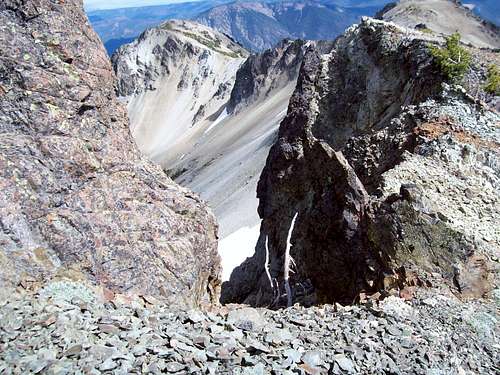
Off we go on the trail. Yes the trail has MANY switchbacks but this trail wasn't nearly as steep as any of us were expecting (we expected Mailbox or Snoqualmie and were pleasantly surprised) The higher we traveled the clearer the skies became around our area. By the time we made it to the ridge line where the Nelson Ridge meets the Mt. Aix Trail the sun was out and many mountains were coming into views. Unfortunately no volcano views but the still these views were by far much better than we were expecting this morning. We continued along the side of the Mt. Aix trail along the side of Pt. 7438. As we turned the ridge we saw that famous face of Mount Aix. It looked quiet stunning from far away.
As for the weather it was a little cloudy but that clearly wasn't the main story. It was[b] VERY [/b] windy in the exposed areas which made it feel much more like October than August. Kind of brought me back to my New Hampshire days. The good thing about the wind was that their were no bugs, which normally can be a problem on this peak. Still at times the gust were so strong that at times they felt as if they were going to blow us off the mountain.
Once at the base of the summit area of Mt. Aix I saw two other scramblers scrambling straight up the steep talus slope to the summit. It looked like they were doing a Class 3 scramble right up to the summit rocks. Wait , I thought the scramble was only Class 2 over some lose rock and was obviously and that the other option was the trail which would be longer?
Well when I got there I noticed the obvious scramble pattern from the trail and the just seemed to continue through a scree field. I was a little confused at the straight forward scramble approach I saw straight up the south face talus field. After some investigating of the trail, which didn't look that hot and a group discussion we decided to do the scramble route. Going up at first was easy but then we hit some lose rock which was a little unnerving. But with Fran and Jason going ahead and investigating the route they found some of the easier ways across the scramble. Once above the lose rock the scramble in places almost became a path and with some minor maneuvers we were on the summit. I think the route we took was Class 2 to 2+ because we never hit any part that was highly exposed or dangerous.
![Mount Aix]()
![Mount Aix]()
![Mount Aix]()
Once on the summit we finally meet more people from NWHikers.net. They were the ones I saw heading straight up the mountain taking what looked like a clear Class 3 route (much more exposed). We talked to them for a while and then they headed back down the mountain. We did our usual goofing off but only hung on the summit for 40 minutes because there were some dark clouds to the west of us and we were on the tallest peak for a long while.
After hanging on the summit for a little while we decided to take the trail down. At first the trail was nice and it actually lead us to a nice snowfield where both Jason and I did a quick glissade. But then the trail became a little more interesting. Once the trail broke the over the ridge it became somewhat hard to follow, especially when we crossed the scree/talus field. It was slow going there and at one point John took a tumble. He was ok and just fell flat but it just renewed our cautious pace more.
Once we got off the scree/talus fields and back on to the trail we were moving quicker. I got summit fever and decided to charge up to the Peak 7438 and take some pictures at the summit cairn. I am scratching my head at why no one has named these summits yet!!! I just took a two minute break on the summit and continue along the trail where I met right back up with them. We then took a break at the Nelson Ridge Trailhead junction where Todd took lead and quickly got ahead of us. We saw him one other time but he got back to the car roughly 20 minutes ahead of us. As for us we headed down the switchback uneventfully back to the car. Overall it was another wonderful trip another great summit hiking with great people. No we didn't see the volcanoes but the day was far better than we anticipating when we left the parking lot.


Comments
Post a Comment