
|
|
Route |
|---|---|
|
|
32.98281°S / 69.43847°W |
|
|
Scramble + a little bit of easy rock-climbing |
|
|
Half a day |
|
|
Walk-up scramble |
|
|
Class 4 |
|
|
Approach
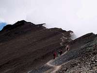
 Cloud drift on the summit ridge
From the ski station, follow the normal trail towards Camp Vega. Walk in a westerly direction past the meadows called Piedra Grande. The trail is easy to find all the way and even if there are other trails leading off in other directions (Cerro Franke, San Bernardo etc.) it's easy to determine which one to follow. The trail gets steeper just before arriving at Camp Salto, a good camp spot which climbers use as base camp for Vallecitos. Personally, I can´t see reason to stay there as it is a pretty long way from Cerro Vallecitos and the next camp spot, Camp Hoyada is equally good and with better views of the high peaks in the range. The Hoyada camp spots are at 5600-5650m and there are water not far away.
Route Description
 Trail to summit
The trail is as easy to follow as before, but it splits in two some hundred meters after Camp Hoyada. It does not really matter which one you choose as they both has some steeper scree sections, which can be a bit annoying as it's the dreadful "one-step-up-a-half-back" in full swing.
Harry adds some input on this:
Just came back from (pico) Vallecitos, with some additions: on teh way up, after Hoyada camp, the left variation of the trail is definitely better, you will not slip at all, the right variation is only for going down, through ankle deep sand, fun to come down :)
Regardless of which one you choose, you´ll end up at the foot of the western approach of a peak called Lomas Amarillas. Follow the path on the ridge towards the higher ridge. When hitting the main ridge, you have to go right/north. There is a small cairn marking the turn-off to the way down, but it is a good idea to put a waypoint in your GPS. If the weather gets nasty, it´s easy to miss the turn-off and walking down the mountain side at the wrong place can lead to very serious trouble. In the NW you have excellent views of Aconcagua and the nearby range of sharp featured monolithic peaks. Follow the trail, which is very easy to find here. When at the foot of a rocky section, you´re at the "summit pyramid" of Vallecitos. I saw some trekkers turn back here, as there are some moves on rock that may be scary for a non-climber. I judged the hardest moves to be 4 scramble, so if you have done a little bit of rock climbing, this is absolutely no problem. Be careful though. If you fall here, it´s a very long way down. A plastic tube, paper and pen can be found on the summit.
 Trail to summit, snow
In order to be 100% correct, this whole mountain page and this route description is all about Pico Vallecitos, the 20 meter lower secondary peak of Vallecitos. If you want to climb the main summit, a full rack of rock-climbing gear and a rope is needed. The main summit is not more than a hundred meters further, but the ridge gets nasty after the secondary peak and first you have to climb down some tens of meters, then traverse on a very sharp ridge and finally climb up to the main summit.
7summits - Dec 25, 2007 12:49 pm - Hasn't voted
Variations upHi Corax, you are correct about Pico Vallecitos vs Vallecitos. The actual summit is higher, but quite difficult to climb, I did not do it. Just came back from (pico) Vallecitos, with some additions: on teh way up, after Hoyada camp, the left variation of the trail is definitely better, you will not slip at all, the right variation is only for going down, through ankle deep sand, fun to come down :) Also on the summit is now a cross with a small tube, where there should be a paper and a pen or pencil. The last scramble can be tricky early in the season: I think I was the first of the season, the scrambling rocks were filled with snow and ice and that made it likely to hard for previous hikers, as the paper was empty and there was no trail through the snow. Cheers, Harry
Corax - Dec 25, 2007 2:35 pm - Hasn't voted
Re: Variations upLong time Harry. I added the info on the Vallecitos route page. Thanks.
davicaetano - Jun 12, 2022 6:05 pm - Hasn't voted
Actual summit through Mt RinconI went to this region in January of 2011 and I did first the lower summit of Vallecitos (with the cross) and some days after I did the traverse from Mt Rincon to Vallecitos, passing through the actual summit. I used crampon and ice axe, but didn't need rope or other gear.
Corax - Jun 13, 2022 12:06 am - Hasn't voted
Re: Actual summit through Mt RinconInteresting. Thanks for the feedback. Personally I wouldn't do that traverse without a rope and some gear. The margins are small, the rock is rotten and the potential falls on both sides of the ridge are very long.