
|
|
Route |
|---|---|
|
|
42.48000°N / 85.39°W |
|
|
Hiking |
|
|
Spring, Summer, Fall, Winter |
|
|
A few days |
|
|
Overview
This section of the North Country Trail (NCT) has a stated length of 86.8 mi, though there have been at least four re-routings since the map was printed. Section MI-02 passes through four counties: Calhoun, Kalamazoo, Barry, and Kent.The trail generally follows the route of the Kalamazoo River west to Augusta and then turns north toward NCT headquarters in Lowell.
The Chief Noonday Chapter maintains the NCT in Calhoun, Kalamazoo, and Barry Counties. The Western Michigan Chapter maintains the NCT in Kent County.
The NCT passes through a few undeveloped areas in this section. These include the grounds of the Fort Custer National Cemetery, the Kellogg Experimental Forest, the Barry State Game Area, the Yankee Springs State Recreation Area, and the Middleville State Game Area. I estimate that 38 of the almost 87 miles is located in these areas. Otherwise, the NCT follows road connectors, rail trails, multi-use paved linear parks, and boardwalks.
Descriptions on this page are made in the New York-to-North Dakota direction.
Most pictures are in the trip and trailhead reports, attached as children, but I have attached some of the scenic ones to this page.
Getting There
In section MI-02, the NCT either crosses or is located near the following highways in Michigan:* I-69: crosses near Marshall
* I-94: generally follows the route of this highway from Marshall to Augusta, crosses east of Battle Creek
* M-66/I-194: crosses in Battle Creek - trailheads available
* M-37: crosses in Battle Creek - trailheads available
* M-96: generally follows the route of this highway from Battle Creek to Augusta - trailheads available
* M-89: crosses near Augusta - trailheads available
* M-43: crosses near Delton
* M-179: crosses in Yankee Springs State Recreation Area - trailheads available
* M-37: crosses again near Middleville
* M-50: crosses near Freeport
Trailheads are located off local roads near (or sometimes on) these highways.
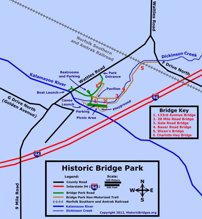
For Calhoun County, parking areas are located at Historic Bridge Park, Kimball Pines Park, Ott Biological Preserve, and along the Battle Creek Linear Park.
For Kalamazoo County, parking areas are located outside of the Fort Custer National Cemetery, on Augusta Drive, at Kellogg Experimental Forest, along C Avenue, at Kellogg Bird Sanctuary, and at Kellogg Biological Station.
For the Barry State Game Area and Yankee Springs Recreation Area, there are trailheads/parking areas on McKibben Road, Norris Road, Bassett Lake Road, M-179 (Chief Noonday Road), and N Yankee Springs Road.
For the Paul Henry Thornapple Trail, there are parking areas on McCann Road and at the Stage Coach Park trailhead in Middleville.
For elsewhere in Barry County, there are trailheads/parking areas on Bowens Mills Road, Peets Road, Crane Road, and along Harris Creek Road at 108th Street (border with Kent County).
For Kent County, the NCT is composed of road connectors for the rest of section MI-02.
Route Description
 Starting section MI-02, heading west (-->ND) from section MI-01
 Starting section MI-01, heading east (-->NY) from section MI-02
Section MI-02 of the NCT starts where route of the trail intersects I-69 near Marshall. The trail proceeds west along roads to Historic Bridge Park, where the route is a paved path through the park.
 Bridges in Historic Bridge Park
After Battle Creek, the NCT follows roads until it enters the grounds of the Fort Custer National Cemetery (though it does not actually go near the cemetery area). There is a very narrow, wood plank bridge in this segment. Emerging from the cemetery grounds, the trail follows M-96 (E Augusta Drive) to cross the Kalamazoo River in Augusta. At this point the NCT turns north. After a short road connector, the trail enters farmland and woods. Eventually, it enters the grounds of the Kellogg Experimental Forest. The NCT through the Experimental Forest ends at M-89 (East D Avenue) and there is a short road connector west along this highway. Then, the NCT turns north to enter private lands and then the grounds of the Kellogg Biological Station, including the Kellogg Bird Sanctuary. From there, the NCT continues north on roads to the south end of the Barry State Game Area.
The NCT enters the game area and eventually crosses Lindsey Road into the Yankee Springs State Recreation Area. In Yankee Springs, the NCT is almost completely trail (one tiny road connector. It joins and runs concurrently with the Hall Lake Trail to climb near to the summit of Graves Hill. (You can walk there in a minute, but there is no view.) Then, the trails descend to a junction, where the NCT leaves the Hall Lake Trail to join the Long Lake Trail, and then the Chief Noonday Trail for a time. Eventually, the NCT returns to the Barry State Game Area (on the north side this time).
Note for county highpointers: the Barry County High Point is also located in the Barry State Game Area, though the NCT does not go near it. Probably the closest it comes is the crossing of the NCT with M-179 (Chief Noonday Road).
 Starting section MI-02, heading south (-->NY) from section MI-03
After the Barry State Game Area, the trail proceeds north along roads, and then follows the Paul Henry Thornapple Trail (a multi-use rail trail) to the town of Middleville. After a short distance on roads in Middleville, the trail proceeds through the Middleville State Game Area with a few short road connectors. After the game area, the NCT continues north along roads, and Section MI-02 ends at the corner of Wingeier Avenue SE and 76th Street SE, south of Lowell in Kent County.
 Leaving section MI-02, heading north (-->ND) into section MI-03
Essential Gear
Typical season-appropriate hiking gear, including bug spray and sunblock.Maps are a good idea, too!
External Links
Chief Noonday Chapter:www.northcountrytrail.org/cnd/index.htm
Western Michigan Chapter:
www.northcountrytrail.org/wmi/index.php
Current guide from the North Country Trail Association:
www.northcountrytrail.org/guide/index.php/Michigan
Maps from the Chief Noonday Chapter (Overview):
Barry County
NCNST Road Connector — Kellogg Biological Station to Barry State Game Area
NCNST in the Barry State Game Area (south segment)
Yankee Springs Recreation Area Trail Re-route
NCNST: Gun Lake Road to M-179 (Chief Noonday Road)
NCNST: M-179 to Peets Road Trailhead
NCNST Road Connector — Peets Road to Irving
NCNST: Paul Henry Thornapple Trail
NCNST Road Connector — Village of Middleville
NCNST through the Middleville State Game Area - South
NCNST through the Middleville State Game Area - North
NCNST Road Connector — Middleville State Game Area to Barry-Kent County Line
Calhoun County
Calhoun County Trails Alliance
NCNST through Kimball Pines
NCNST Road Connector - Kimball Pines & Ott Biological Preserve
NCNST through the Ott Biological Preserve
NCNST Road Connector - Ott Biological Preserve & Battle Creek Linear Park
NCNST Road Connector - Battle Creek Linear Park & Fort Custer
Kalamazoo County
NCNST through Fort Custer
NCNST Road Connector — Fort Custer to Augusta Drive Trailhead
NCNST: Augusta Drive to C Avenue
NCNST through the Kellogg Biological Station
Link for purchasing map MI-02:
www.northcountrytrail.org/shop.php?item_id=220&category_id=54
For Historic Bridge Park, there is also a nice map (attached) from the Historic Bridges website (historicbridges.org):
www.historicbridges.org/info/bridgepark/bridgepmap.jpg
Battle Creek Linear Park map:
www.bcparks.org/pdf/BC_LinearPark.pdf
Yankee Springs Recreation Area map:
www.michigandnr.com/Publications/PDFS/RecreationCamping/yankee_springs_map.pdf
Paul Henry Thornapple Trail:
www.thornappletrail.com
USGS maps can be downloaded at:
www.usgs.gov
Maps and Route Changes
Map: MI-02 -- Marshall to 76th StreetThere have been some changes to the route of the NCT since the current version of map MI-02 was created.
1) Wattles Park:
The trail route differs from the map after leaving Historic Bridge Park. Instead of entering an uncertified trail segment, the NCT is now well blazed on the following roads:
* Turn right from the park and go north on South Wattles Road for about 0.7 miles.
* Turn left onto Crosby Drive and go to the end of the road, about 0.5 miles. The road ends at a now unused school, which is the former Wattles Park Jr High School (it is still used for some civic meetings and the fields are used for sports).
* The trail leaves roads again around the left (south side of the school). Look for the blue blazes from the end of Crosby Drive. From here, the NCT proceeds west to Kimball Pines County Park.
2) Barry State Game Area and south:
The rough trail from Keller Road to the McKibben Road trailhead has been withdrawn from use. Therefore, the road connector proceeds as follows:
* At the corner of Norris Road and Keller Road, do NOT turn right onto Keller; stay straight on Norris
* Turn right onto Mullen Road.
* Turn left onto McKibben Road and in a short distance (~0.5 miles) look for the trailhead on the right and trail across the street on the left.
3) Yankee Springs Recreation Area:
There have also been some trail re-routings in Yankee Springs Recreation to move it from some of the horse trails. Refer to the Chief Noonday Chapter website for the current map mash-up.
4) Kellogg Biological Station:
The trail route has now been re-routed from the road connector on N 39th Street to trail on the grounds of the Kellogg Biological Station. Refer to the Chief Noonday Chapter website for the current map mash-up.
USGS 7.5 Minute Topos (all in Michigan):
Marshall
Ceresco
Battle Creek
Augusta
Banfield
Delton
Cloverdale
Middleville
Alto
Freeport
Notes and Revision History
Submissions and suggestions welcome to improve this page!Revision history:
04 Apr 2010 - page created
21 Apr 2010 - map information added, route edited, more external links added
25 Apr 2010 - trailhead and parking information added
27 Apr 2010 - editing
01 May 2010 - trailhead and map info corrected
04 May 2010 - editing, map info and external link added
06 May 2010 - note on pictures added
11 May 2010 - updates to make status current for Overview, Route Description, and Maps sections
12 May 2010 - added Kellogg Bird Sanctuary trailhead
07 Jun 2010 - major editing to Getting There, and Maps and Route Changes; edited to section titles, Overview, and External Links
20 Jun 2010 - editing, updates added to Maps and Route Changes, pictures added
21 Jun 2010 - editing
15 May 2011 - pictures added and links checked/updated/added
27 May 2011 - Route Description corrected
09 Jun 2011 - new route change added; Overview edited
01 Jul 2011 - editing