
|
|
Mountain/Rock |
|---|---|
|
|
39.68751°N / 119.45145°W |
|
|
Washoe |
|
|
Hiking |
|
|
Spring, Fall, Winter |
|
|
7919 ft / 2414 m |
|
|
Overview
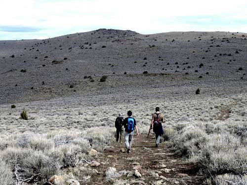
Group heading towards North Pond Peak
North Pond Peak is a summit in the Pah Rah Range located 2 ½ miles north of Pond Peak 8,031’. Not specified on topographic maps, nor officially named, North Pond Peak has a prominence of 414’ above its saddle with Pond Peak. It shouldn’t be confused with the summit just north of the dry pond. That is just a sub-summit of North Pond Peak and lacks prominence.
Like Pond Peak, North Pond Peak is accessible from the east or the west. The east route is easier to access, while the west route is shorter from the start of the trail, but requires a good 4WD vehicle to reach legal access.
It is odd that North Pond Peak was never identified on topographic maps. It is located along the high ridge of the Pah Rah Range which reaches its apex at 8,367’ at Virginia Peak and is anchored on the south end by Pond Peak. There is barely any prominence from other summits along the ridge. In fact, North Pond Peak appears to be the third highest summit in the Pah Rah Range. Pah Rah Mountain 8,247’ is named, but is well below 300’ of prominence.
Views from North Pond Peak extend deep into Nevada. From the summit, we could see mountains more than 80 miles away rather clearly. There aren't any views of Pyramid Lake.
The high ridge of the Pah Rah Range can essentially be hiked any time of year depending on conditions. It is not advised to access the range when roads are muddy. However, dry roads are possible in winter months. It is not recommended to hike here during the summer months. Ideal times are February-April and October through early December.
Getting There
The primary route to the summit is from the east side approach. Take I-80 East to exit 43, to the Wadsworth exit (427) heading northeast. Drive slow, as you are now in the Pyramid Lake Paiute Reservation. Follow signs to 447, and take it north for about two miles. On the left is Olinghouse Road. Follow this well graded dirt road for about 5 ½ miles. At this point, you will see a sign for private land. Supposedly there is a locked gate at this point, but we did not see the gate when we were there on 11/12/2011. The private land continues for about 1 mile, and then there is a sign for public access. The private land continues to the north at a big mining operation. You have to drive up to the top of a small hill to reach public land, which can be tricky for small cars, or 2WD without front-wheel drive. There is a small parking area on the left side of the road at about 5870’.From the west side, take I-80 east to exit 18 (Pyramid Highway – Highway 445). Follow Pyramid Peak north through Spanish Springs, and continue as the road becomes two-lanes. It is 18 miles north of I-80 to the turn off. The turn off is just before the Wild Horse Corral. At the turnoff, follow Ironwood Road, a partially paved road that is covered in dirt. Follow Ironwood Road for 4.8 miles to a T junction with Amy Road. Take a right on Amy Road and follow it for about 0.4 miles where the road curves to the left and turns into Wilcox Ranch Road. Follow Wilcox Ranch Road for about 8 miles. The road starts to get rough after you pass a house with a pond on the right. While Left Hand Canyon Road is an ideal road about 1/2 mile past the house to start a hike up to North Pond Peak, there are signs clearly restricting public access. Other signs urge automobiles to continue past private lands, which leads to a starting point at a jeep road on the right about 2.6 miles past the house with the pond. This road is at 39.66893, -119.47429 at 7,198'.
Route Information
From the east side, the best way to approach is just to climb Pond Peak first. From the parking area, head up the first hill for just over 1/4 mile, and then leave the road and head right up the ridge. This is the most straightforward way up to the summit of Pond Peak. This is the “East Ridge” of the mountain. It is less than 2 miles to the summit once leaving the road, and although there is no trail, it is very straightforward.Once atop Pond Peak, head east along the ridge, and cut down to the pond below. Once at the pond, take the road heading northeast. You will go up and over a ridge and come back down to a road heading straight towards North Pond Peak. The one-way distance is about 5 miles total gaining nearly 3,000’ if doing Pond Peak first.
From the west side, if parking at the jeep road on the right, follow the road for about 1/3rd of a mile and turn left on another jeep road. This road heads straight up to the saddle just south of North Pond Peak. It is 2 ½ miles to the summit and gains about 700’. Of course, if driving all this way it is recommended you combine North Pond Peak with Pond Peak. To do this hike up Pond Peak Road first to the summit of Pond Peak. Then follow the same directions as above from the summit of Pond Peak to ascend North Pond Peak. Descend via the jeep road back to the parking area. The total distance is about 7 1/4 miles gaining about 1,500' combined for both summits.
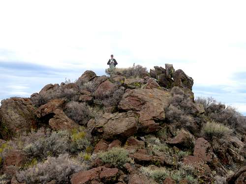
North Pond Peak rocky summit
Red Tape
North Pond Peak is mostly on public lands managed by the Bureau of Land Management. From the east side, please drive slow through the Pyramid Paiute Reservation, which is crossed on the way to the mountain. Do not park on the private land on Olinghouse Road. Drive through it to get to public lands. There are signs saying you can drive through to access public lands.Watch for signs if approaching from the west. Don’t be deterred at any point. You can legally go all the way up the road. Some side roads are off limits.